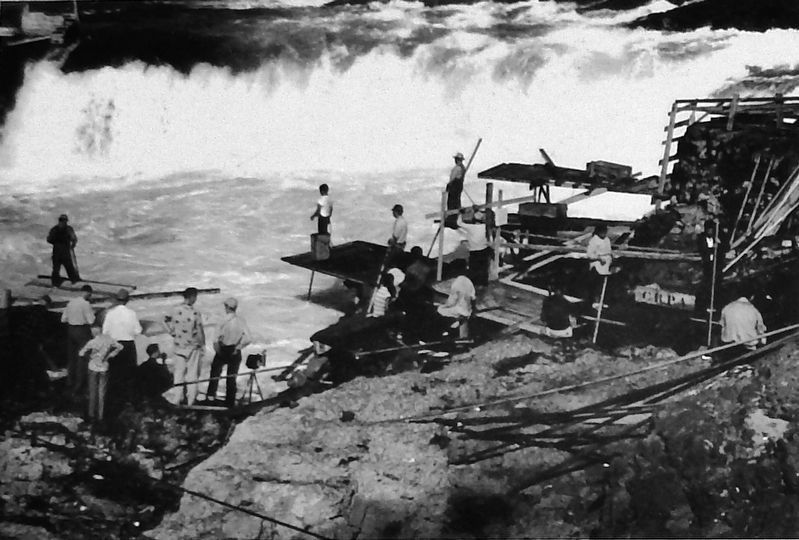
American Indians have harvested salmon from the Columbia River for over 10,000 years. Celilo Falls, a sacred location, now lies beneath the waters of the Columbia, directly east of the railroad bridge you see below. The loss of this fishery at . . . — — Map (db m128967) HM
In 1923, the Great Northern Railway received 28 Class P-2 “Mountains” from the Baldwin Locomotive Works. These locomotives were assigned numbers 2500 through 2527 and had 29 X 28 cylinder, 73” drivers, a 200 psi boiler pressure, a . . . — — Map (db m128995) HM
The Lewis and Clark Expedition reached Celilo Falls, its first major obstacle on the Columbia River, on October 22,1805. William Clark named this imposing stretch of the river “Great Falls of the Columbia.” For millenia, tribes . . . — — Map (db m128969) HM
William Clark took frequent side trips during the journey, sometimes climbing hills to get a better view of the surrounding countryside. On April 22, 1806, Clark scaled Haystack Butte, the highest hill on this side of the river (over your left . . . — — Map (db m128966) HM
Since time immemorial, the area surrounding Celilo Falls was the hub of a vast American Indian trade network that stretched from California to Alaska, and from the Missouri Plains to the Pacific Ocean. Native people established this trading center, . . . — — Map (db m128968) HM
Centennial Square, a project of the Foundation For The Community of Sunnyside, is built on property first owned by J.B. George. He sold his general merchandise, implements business, and property to two employees, Albert and Charles Amundson, in . . . — — Map (db m302228) HM
Community leader and Father of the Roza Irrigation Project.
From the first settlement of the Lower Yakima Valley, there was a dream to build a "high line canal" to irrigate lands above the Sunnyside Valley Irrigation canal. The vision for . . . — — Map (db m302223) HM
First Plaque
The American Legion and Veterans of Foreign Wars dedicate this monument in memory of Jerry Taylor for his honorable service to country and community. He honored all veterans in his pursuit of patriotism and love of country. He . . . — — Map (db m302231) WM
Kloochman Rock is a volcanic "intrusion" composed of what is called a "pyroxene-rich andesite." Intrusions are created when molten volcanic material is pushed up into a fissure or crack where it cools and hardens. Andesite is a relatively hard fine . . . — — Map (db m71522)
In the early days of Toppenish history the settlers worked from sunrise to sunset for weeks at a time. Each family pulled and burned acres of sagebrush and greasewood to make room to plant their crops. We salute these pioneers of our area.
This . . . — — Map (db m129699) HM
In the years gone by the entire potato crop was picked from the field by hand. It was backbreaking work and took strong men and women to do the job. Potatoes were one of the first crops to be raised in this valley when it was settled.
Fred . . . — — Map (db m129763) HM
7 1/10 miles South 10° West of here is a marker where Captain A. J. Hembree was killed by Indians April 10, 1856. Spot located by Lieutenant W. D. Stillwell of Captain Hembree’s Company, and Yakima tribesman Wy-Kolas. — — Map (db m129696) HM
Hops, potatoes, hay, wheat, melons and row crops all were shipped from this area in the early days of Toppenish. Artist Robert Thomas of Kooskia, Idaho shows the various ways the produce was moved at that time.
The Toppenish Mural . . . — — Map (db m129759) HM
Charlie Newell’s knowledge of the Indian language and his wide acquaintance with the Yakama Indians enabled him to avert a crisis in which a massacre seemed imminent. The Indian Agency had forbidden the racing of horses and gambling at their meets. . . . — — Map (db m129700) HM
During the long cold winters, the Indian braves spent time hunting, and the women handled the cooking and clothing. The winter lodge was the gathering place for social functions. Painted in the summer of 1992 by Bothell, Washington artist Hulan . . . — — Map (db m129760) HM
Born to parents who arrived in the valley by covered wagon, “Lou” Shattuck grew up here. He loved horses and at age 15 was driving a stage coach. Famous for his six horse hitch, he won many gold medals, blue ribbons and cash prizes. Lou . . . — — Map (db m129698) HM
In 1884 Charley Newell, a Toppenish pioneer, drove 700 horses from this area to Kearny, Nebraska, which was the nearest railhead at that time. During the following years these horses were involved in four wars around the globe. Painted by Don Crook, . . . — — Map (db m129761) HM
Originally called the "Fall Roundup," the rodeo has been part of the history of Toppenish since the late 1800's. In 1913 it was changed to "Rodeo" and later to "Pow Wow & Rodeo." This old worn poster brings back many fond memories of past rodeos to . . . — — Map (db m129764) HM
The patterns on these Pendleton blankets were taken from a 1905 catalog. They are authentic. Painted by artist Robert Morgan of Clancy, Montana in May of 1992. The traders of that era were the first whites to befriend the Indians.
The . . . — — Map (db m129765) HM
The Toppenish area around the 1890’s had 4 blacksmith shops. These shops were the hub of activity at that time. Rebuilding a wheel for a freight wagon, shoeing horses or making new parts for machinery the “smithy” was there. These were . . . — — Map (db m129766) HM
In the late Spring of 1855, representatives from the major tribes of Washington Territory gathered in council at Walla Walla. Chief Ka-Mi-Akin was the leader of the Confederacy of Tribes & Bands. The Yakima Treaty created a reservation of . . . — — Map (db m129697) HM
Indian tribes from throughout the Northwest gathered to pick hops by hand. Hop growing in Washington State started in the early 1800's. During the daylight hours, the hops were picked and the evenings were spent in relaxation such as playing the . . . — — Map (db m129762) HM
In memory of Tow-tow-nah-hee a non combatant killed 3-1/2 miles north of here by Ow-hah-tah-ma-so a gov't scout. Yakima War 1855-56. The only Indian hurt in the Battle of Pah'-qy-ti-koot. — — Map (db m305181) HM WM
The Old North Yakima Historic District was created and placed on the National Register on May 2, 1986, by the National Park Service, U.S. Department of Interior.
The Burlington Northern Freight Depot (Northern Pacific Company and Freight Depot) . . . — — Map (db m129400) HM
The Old North Yakima Historic District was created and placed on the National Register on May 2, 1986, by the National Park Service, U.S. Department of Interior.
The Burlington Northern Passenger Depot (Northern Pacific Railroad Passenger Depot) . . . — — Map (db m129403) HM
The Old North Yakima Historic District was created and placed on the National Register on May 2, 1986, by the National Park Service, U.S. Department of Interior.
The Lund Building is a contributing member.
Built by A. F. Switzer for Thomas . . . — — Map (db m129405) HM
The Old North Yakima Historic District was created and placed on the National Register on May 2, 1986, by the National Park Service, U.S. Department of Interior.
The Old City Hall is a contributing member.
Built in 1889 by A. F. Switzer for . . . — — Map (db m129406) HM
The Old North Yakima Historic District was created and placed on the National Register on May 2, 1986, by the National Park Service, U.S. Department of Interior.
The Senator Apartments (Hotel Sydney) is a contributing member.
The Hotel . . . — — Map (db m129408) HM
The Old North Yakima Historic District was created and placed on the National Register on May 2, 1986, by the National Park Service, U.S. Department of Interior.
The Opera House is a contributing member.
The Opera House was built by A. F. . . . — — Map (db m129407) HM
This property was placed on the National Register of Historic Places in 1985 by the United States Department of Interior Teapot Dome Service Station — — Map (db m222600) HM
131 entries matched your criteria. Entries 101 through 131 are listed above. ⊲ Previous 100