313 entries match your criteria. Entries 301 through 313 are listed.⊲ Previous 100
Windmills Historical Markers
Windmills have been used by humanity for more than a millennia to harness power for a variety of work. The series includes markers describing actual windmills and replica non-working windmills built for tourism, novelty, or other purposes. (It does not include markers that simply include the word Windmill in the text.)
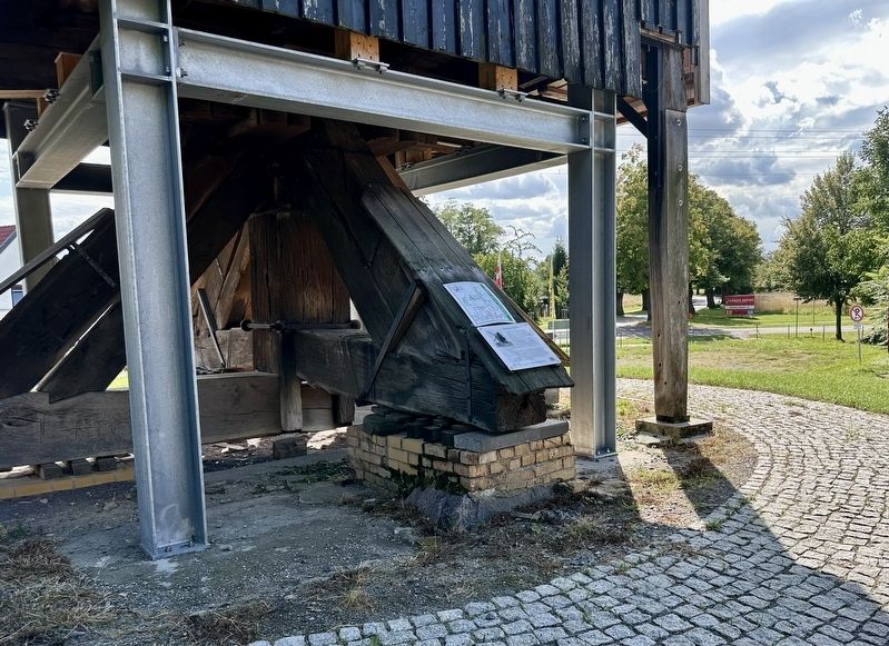
„Schmidt-Mühle“ (Bockwindmühle)
Denkmalgeschütztes Gebäude
Der Mühlenstandort ist seit dem 16. Jahrhundert
nachgewiesen. 1759 erwarb Johann August Schmidt
die Mühle. 226 Jahre blieb sie im Eigentum der
Familie Schmidt. Sechs . . . — — Map (db m283395) HM
Sugar Sugar was introduced to the New World by Columbus on his 2nd voyage. In 1493, he took canes from Gomera in the Canaries to Hispaniola. It is recorded that Francisco Garay, Spanish Governor in 1527, built a mill and made good sugar. The . . . — — Map (db m129957) HM
Krijtmolen d’Admiraal
Opdrachtgever Elisabeth Admiraal
Bouwjaar 1792
Krijtmolen d'Admiraal werd in 1792 opgericht door de 90-jarige Elisabeth Admiraal, zij was de eerste eigenaresse. De laatste eigenaar die
van de molen . . . — — Map (db m268474) HM
🇳🇱Deze in 1991 herbouwde stellingmolen dateert uit 1847. Het is een
nog werkende poldermolen die een groot deel van Amsterdam West
drooghoudt. De molen kan 60.000 liter per minuut omhoog brengen.
De meeste onderdelen . . . — — Map (db m252140) HM
De Kostverlorenvaart is in de vijftiende eeuw gegraven om de afwatering van het Hoogheemraadschap van Rijnland op 't IJ te verbeteren. Omdat hiermee een ongewenste
open verbinding met het buitenwater ont-
stond, werd de vaart afgedamd. . . . — — Map (db m213258) HM
Molen De Otter
Architect onbekend
Bouwjaar 1638
De strook ten oosten van de Kostverlorenvaart
stond in de 17e eeuw bekend als molenbuurt.
Er stonden voornamelijk houtzaagmolens,
maar liefst 49.
De Otter is als enige . . . — — Map (db m268088) HM
Vóór 1627 werd er in Amsterdam vrijwel alleen
met handkracht hout gezaagd. In 1630 werd
een compagnie gesticht voor het oprichten
van houtzaagmolens. Tussen de Haarlemmerpoort en Raampoort verrezen 12 zogenaamde
paltrokken: De . . . — — Map (db m216176) HM
Replica van de, uit 1619, houten korenmolen van
Jan Janszn Put.
Na een inzamelingsactie onder de Leidse bevolking vond
in 1987, naar oorspronkelijk model, de herbouw van de
molen plaats.
De houten standerdmolen, één van de oudste . . . — — Map (db m216339) HM
Battle of Lewes 14th May 1264
Led by Simon de Montfort, Earl of Leicester, and Gilbert de Clare, Earl of Gloucester, the rebel army, with Londoners on the left flank, occupied the high ground. Henry III and his brother Richard, King of the Romans, . . . — — Map (db m129646) HM WM
The mound was first created in the first or second century as one of several burial mounds south-east of the early Roman town. By the time the Roman town walls were constructed (AD 270-90) it was still of sufficient size to be incorporated into the . . . — — Map (db m279915) HM
Historic Village
Martin Mill
Martin Mill lies on-an ancient trackway from St. Margaret's Bay near Dover leading towards Canterbury. In the middle of the 18th century a miller from St. Margaret's built an early type of Kentish smock windmill . . . — — Map (db m128671) HM
Roaring Meg
Roaring Meg is the most famous of the city's cannon. She weighs a mighty 1794 kilograms. The Fishmongers' Company of London presented her to the city in 1642. She saw action in the 1689 siege, probably from this bastion. It . . . — — Map (db m71007) HM
[Keyed photo of Double Bastion overlook]
1. Lumen Christi College - co-educational school on the site of Bishop Hervey's casino.
2. The Windmill - the stump of the building fought over during the 1689 siege.
3. St Columba's, Long Tower . . . — — Map (db m71004) HM
313 entries matched your criteria. Entries 301 through 313 are listed above. ⊲ Previous 100