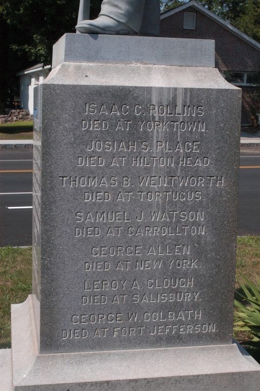
Main inscription Dedicated to the memory of those who enlisted from Alton in the War of 1861-65. Died in defense of their country and sleep in unknown graves. Erected by M.H. Savage Post GAR
Side 1 Issac C. Rollins Died at Yorktown . . . — — Map (db m96739) WM
Main inscription Viet Nam Conflict Honor Roll
followed by 2 rows of 70 names.
Reverse inscription Dedicated Mar 30 1987 Erected by Town of Alton and American Legion Post 72 — — Map (db m96743) WM
Honor Roll
This memorial is dedicated to the men and women who served their country for the cause of freedom
1941 World War II 1945 4 rows of names are inscribed.
Those who made the supreme sacrifice 8 names are inscribed.
1950 Korea 1953 . . . — — Map (db m96745) WM
Erected by the town of Alton N.H. honor roll of her soldiers and sailors 1914 World War I 1919
Top row: 3 names with Stars
Then 4 rows of inscribed names
*Died in the service of our country — — Map (db m96747) WM
This location became a transportation center on August 30, 1851, upon completion of the Cocheco Railroad from Dover to Alton Bay. The first "Mount Washington" steamboat was built here in 1872. For forty years a railroad terminus, here northbound . . . — — Map (db m96751) HM
This patriot and civic leader rests in a nearby grave on land he once farmed. In 1764 he contracted to build Barnstead's portion of the Province Road. On December 14-15, 1774 he participated in raids on the British Fort William and Mary in New . . . — — Map (db m235107) HM
Belmont Mill
The Gilmanton Village Manufacturing Co., under
the leadership of Gov. William Badger, built
the Belmont Mill in the 1830s. It first produced
cotton cloth, but was converted to hosiery
knitting in 1865. In 1885, it had the . . . — — Map (db m261113) HM
From 1889 to 1929 the Belmont Spur Railroad ran from
Tilson Junction to serve Belmont and its Mill. The route
crossed from the Winnipesaukee River on a wooden
trestle bridge below Silver Lake and then crossed the
Tioga River twice. The final . . . — — Map (db m261115) HM
Founders Dr. Royal M. Frye and Dr. Virginia M. Brigham were visionaries, educators, and mentors who brought together faculty, administrators and students for an outstanding education. While Degrees were earned, all who attended gained lifelong . . . — — Map (db m97063) HM
Author and publisher of almanacs first appearing in 1797. Best known was "Leavitt's Farmers' Almanac and Miscellaneous Year Book" which was continued after his death for about 45 years. This publication provided
information vital to domestic and . . . — — Map (db m235449) HM
One of the earliest highways in New Hampshire, it was authorized in 1765 as a supply route from the tide-water port of Durham to the colony's northern settlements in the Coos. This section of the road through Gilmanton was built in 1770 nine . . . — — Map (db m235104) HM
National Society
Women Descendants
Ancient and Honorable
Artillery Company
Massachusetts
1637 — 1774
Honors Two Charter Members
John Endicott and Edward Johnson
Captain Johnson surveyed
this area in 1652
for the . . . — — Map (db m282505) HM
Endicott Rock
the name of
John Endicvt Gov.
and the initials of
Edward Johnson and Simon Willard, Commissioners
of the Massachusetts Bay Colony,
John Sherman and Jonathan Ince, Surveyors,
were inscribed upon this rock
August . . . — — Map (db m308750) HM
In honor of the 12th Regt. NH Vols. who fought in the war of 1861-1865 for the preservation of the Union. Erected by Major E.E. Bedee — — Map (db m96730) WM
1941-1945 Meredith Honor Roll
There are 3 panels of inscribed names, with 4 starred names, indicating they gave their lives in the conflict — — Map (db m96732) WM
The history of Lochmere, in the broadest sense, is the history of human use of the Winnipesaukee River. Navigable by canoe, the river served as a major transportation and communications route and, with falls and rapids, it has served as a source . . . — — Map (db m261116) HM
Native Charles E. Tilton shaped his hometown through his many gifts of monuments, buildings and parks – places that make the community special today. After moving to the West Coast in 1850, Tilton acquired extraordinary wealth through his trading . . . — — Map (db m261118) HM
Situated on the Winnipesaukee River, the town of Tilton was a prime location for a variety of mills in the late eighteenth and early nineteenth centuries. The products produced in Tilton during the height of the mill manufacuring period included . . . — — Map (db m97228) HM
In 1850, approximately 100 years after the town of Sanbornton was settled, a group of citizens petitioned to form a new town. Voted on at a special town meeting in 1869, and approved by the voters and the governor of N.H., the town of Tilton was . . . — — Map (db m97229) HM
In the eighteenth and nineteenth century, the power of the Winnipesuakee River was harnessed to operate mills up and down its banks. These banks were home to several gristmills, woolen mills, and other textile mills. Many dams existed in this . . . — — Map (db m97231) HM
In honor of those from the town of Tilton who devoted themselves to the cavse of freedom in the service of ovr covntry --1914-1919 -- They served without thovght of self that the principles of liberty, jvstice and eqvality might prevail for all . . . — — Map (db m97194) WM
This snow roller, donated by Francis Savard of Intervale Farm, was once used to roll the roads in the Intervale section of Bartlett. Prior to the advent of snowplows, snow rolling was a common method of keeping the snow-covered roads passable in . . . — — Map (db m160823) HM
This piece of Sawyer's Rock represents the traditional landmark for the town line between Harts Location and the town of Bartlett. In 1870, Benjamin Sawyer and his partner Timothy Nash set out to prove to governor Wentworth that men and horses . . . — — Map (db m160826) HM
This rustic cottage was once the home of Thomas Murphy and his wife, Lady Blanche, daughter of the Earl of Gainsborough. Thomas was the organist at the church on the Earl's estate. The commoner and the lady eloped to America, where Thomas taught at . . . — — Map (db m77640) HM
New Hampshire Fish & Game Law Enforcement
Served 1990 - 2013
Steadfast and committed to protecting the wildlife and citizenry of this great state — — Map (db m239144) HM
The high steel trestle above was built in 1893 to replace a wrought iron trestle of 1875, and was strengthened in 1930 and 1950. Named for American Artist Godfrey N. Frankenstein (1820-1873), the adjacent cliff and gulf were formidable barriers to . . . — — Map (db m77698) HM
In 1771, Timothy Lash of Lancaster and Benjamin Sawyer of Conway made a bargain with Governor John Wentworth to bring a horse through Crawford Notch in order to prove the route’s commercial value. The pair succeeded by dragging and lowering the . . . — — Map (db m239145) HM
Was fought between 1722 and 1725 against several tribes of eastern Indians. The principal campaigns took place in the Ossipee region and led to the eventual withdrawal of the Indians to the north. Commemorated in Colonial literature by “The Ballad . . . — — Map (db m152069) HM
Governor John Wentworth and the King's Council voted in the spring of 1771 that a highway be made from the Governor's estate at Wolfeborough to Dartmouth College.
Joseph Senter, David Copp and Samuel Shepard surveyed the 67-mile road which . . . — — Map (db m234615) HM
Stuarts in North Africa Stuart tanks First saw combat with the British in Operation Torch (November 8-11, 1942) during the North Africa Campaign (June 10, 1940-May 13, 1943). Of the more than 700 tanks that took part in the operation, about 170 . . . — — Map (db m152106) HM
Two photos show the station at very different times. The one above is early on when the area was still called Mill Village and taken perhaps even before 1900 when the station first housed the Post Office. In 1892 the PO was subsequently moved across . . . — — Map (db m152101) HM