On Cork Street at Chairmans Lane, on the left when traveling north on Cork Street.
Thóg Maurice Bacach Fitzgerald, larla Dheasmhumhan Caisleán Deasmhumhan c. 1500. Sampla maith de theach túir uirbeach, is éard atá sa chaisleán ná daingean le tithe stórais ar cúl agus oifigí tí ar an gcéad agus ar an dara hurlár. Tógadh . . . — — Map (db m137073) HM
On Friar Street just west of Cork Street, on the right when traveling west.
Sna 1830'aidí, ag deireadh ré na bPéindlíthe, tógadh Séipéal Eoin Baiste, in áit foirgneamh díon tuí a bhí níos lú. Dhear an Bráthair Michael Augustine O'Riordan an stíl clasaiceach atá air agus dhear sé roinnt séipéal eile i gCorcaigh . . . — — Map (db m137067) HM
On Market Lane, on the right when traveling north.
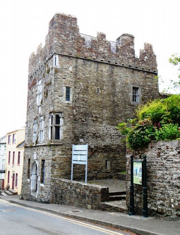
Múseum (Teach na Cúirte)
Teach na Cúirte atá anois air ach be é Teach an Mhargaidh é ar dtús, croilár tráchtála an bhaile áit a mbítí ag trádáil sna háirsí ar urlár na talún. Tógadh é thart ar 1600. Dúnadh roinnt de na háirsí i 1706, . . . — — Map (db m137111) HM
On Pearse Street (Munster Route R605) at Market Lane/The Glen, on the right when traveling north on Pearse Street.
We recently completed the restoration of the Old Kinsale Fish [M]arket wall adjoining the Blue Have[n] Hotel which now forms the entrance to the Blue Haven Bar and surrounding areas. The Blue Haven Hotel is built on the site of the Old Fish . . . — — Map (db m137173) HM
On Pier Road (Munster Route R600) 0.3 kilometers south of Emmet Place, on the left when traveling south.
I 1588 shocraigh Philip III, i ndiaidh theip Armáid na Spáinne agus scrios phéire eile i stoirmeacha i mblianta deiridh Philip II, go dtabharfadh sé tacaíocht dhíreach do lucht éirí amach na hÉireann a bhí ag troid Shasana le súil agus go . . . — — Map (db m137476) HM
On Cork Street (Munster Route R600) at Market Lane, on the left when traveling south on Cork Street.
Tógadh Rinn Chorráin déanach sa 17ú céad ar shuíomh dhaingniú chósta níos luaithe. Is sampla claisiceach é de dhún réaltógach. Tá Rinn Chorráin ar cheann de na dúin mhíleata is mó sa tír agus tá ceangal aige le cuid de na heachtraí is . . . — — Map (db m137242) HM
On Pier Road (Munster Route R600) just south of Emmet Place, on the right when traveling north.
Tar éis Chath Chionn tSáile thosaigh obair thógála ar An Seandaingean i 1602 faoi stiúrthóireacht an Innealtóra Paul Ive. Críochnaíodh é i 1604 ar chostas £645. Is dún mór, urdhúnta, peinteagánach, é An Seandaingean agus é taobh istigh de . . . — — Map (db m137244) HM
On Church Square just west of Cork Street, on the right when traveling west.
Timpeall 1200 thóg na Normannaigh Teampall Mheilteog ar shuíomh an aireagail 6ú aoise agus níl mórán athrú déanta air, agus é ina ionad adhartha ag Críostaithe sa mbaile ó shin. Tá túr suntasach ann agus roinnt fuinneoga daite agus . . . — — Map (db m137360) HM
On Pier Road (Munster Route R600) at Emmet Place, on the right when traveling south on Pier Road.
The restored Fish Shed (using recycled material) is a living link with Kinsale's thriving fishing industry of old. Hundreds of Kinsale hookers, small inshore craft with 3 man crew, were joined by fleets from other parts of Ireland, the Isle of . . . — — Map (db m137269) HM
On Market Square at Guardwell, on the right when traveling east on Market Square.
Kinsale is a sea-port, parliamentary borough, and market town, in the parishes of Saint Multose and Ringcurran barony of Kinsale, County of Cork, 172 miles s.w. from Dublin, 12½ s. and 11 e.s.e. from Bandon; eligibly situated near the . . . — — Map (db m137282) HM
On Market Lane at Milk Market, on the right when traveling west on Market Lane.
there were four walled towns in county cork: cork city, youghal, bandon and kinsale. as with walled towns all over europe in the middle ages, the purpose was to provide security against attack and to create a commercial and political entity. in . . . — — Map (db m137145) HM
On Market Street at Milk Market, on the right when traveling west on Market Street.
History: Kinsale Town Wall
In the year 1381, King Richard II of England declared that the town of Kinsale being situated on the sea shore and of late having recieved [sic] insult and attack from Spanish and Irish enemies and . . . — — Map (db m137118) HM
On The Glen (Munster Route R605) just north of Market Lane/Pearse Street, on the left when traveling north.
Restaurant D'Antibes dedicated to the
formal twinning between
Kinsale-Cionn TSáile and Antibes-Juan Les Pins
Signed by Cllr. Michael Frawley
Chairman of Kinsale U.D.C.
and M. Pierre Merli, Mayor of Antibes-Juan Les Pins
on 28th of . . . — — Map (db m137170) HM
On Pier Road (Munster Route R600) 0.3 kilometers south of Emmet Place, on the left when traveling south.
In memory of
all lost seafarers
from the port of Kinsale
Kinsale Hooker
19th c. Fishing vessel
His hooker's in the Scilly Van
when seines are in the foam
but money never made the man
nor wealth a happy home.
So, blessed . . . — — Map (db m137497) HM
The Kinsale Tidy Towns project for 2018 was for the erection of this sign which details a number of nautical items which are stored here at the back of the Museum (see photos No's 1,2 & 3). It entailed some restoration work on some of the items, . . . — — Map (db m137116) HM
On Market Lane, on the right when traveling north.
Peter Barry arrived in Kinsale in 1963 and settled in Scilly where he made his home. In those early years he operated and developed Scilly's unique Spaniard Pub and the Man Friday restaurant, and later the Grey Hound Bar in Market Place.
Peter . . . — — Map (db m137075) HM
On Market Lane at Milk Market, on the right when traveling west on Market Lane.
Up to this time, William Smith & Sons had relied almost entirely on the increasing trade in sweepers, scrapers, spare parts and brushes. The range of machines available had been frequently updated and fifteen types of sweepers were now being . . . — — Map (db m137148) HM
On Church Square just west of Cork Street, on the right when traveling west.
In the days when Kinsale was a great maritime centre it was an important port of call for fresh water. It was known in Irish as Fan na dTubraid, the Slope of the Springs/Wells and there were many public and private wells in the town. Some were the . . . — — Map (db m137271) HM
On Market Square at Guardwell, on the right when traveling east on Market Square.
The Town Pound was an essential part of the administration of the old town, located near the Market House, the Potato Market and the Broadstone. It had replaced the Old Pound at the top of Barrack Street and was for the care of stray livestock, . . . — — Map (db m137294) HM
On Pearse Street (Munster Route R605) at Market Lane/The Glen, on the left when traveling north on Pearse Street.
This plaque
commemorates the official opening
of the refurbished premises by
The Honourable Patrick J. Kennedy,
Member of Congress,
Rhode Island, USA.
14th. April, 1998. — — Map (db m137169) HM