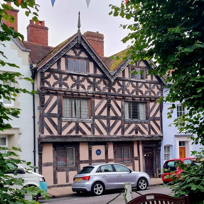
A draper's shop since the 17th century. Boyhood home of Sir William Jukes Steward (1842-1912), Speaker of the New Zealand House of Representatives. — — Map (db m233025) HM
The Bull has been an inn since the fifteenth century, when the formerly galleried range in the yard was erected. Remains of an earlier roof dating from c.1350 still exist in the main block of the building.
In the fifteenth century the premises . . . — — Map (db m232799) HM
Castle Square is the remnant of a much larger market place which was the spine of the original Norman Town Plan. It extended from the Castle to what is now the Bull Ring. The eastern two thirds was filled by encroachments and rows of shops but the . . . — — Map (db m313811) HM
The Church and the surrounding square owe much of their appearance to the religious Palmers Guild of Ludlow C.1284-1551.
College Street takes its name from the College of Cannons or Priests of the Palmers Guild founded well before the . . . — — Map (db m233565) HM
Built or probably rebuilt about 1704 by Mr. Richard Davies a wealthy burgess. In 1719 owned by the Knight family of Downton Castle, and later of Croft Castle. Tenanted by Lord Powis in 1780 and owned by his brother-in-law Lord Clive 1795. Lucien . . . — — Map (db m232907) HM
An older building was enlarged and refronted in 1619. It was the home of Rees Jones of Pembrokeshire, an Attorney at the Council of the Marches. His initials are on the lock plate.
Became an inn c.1670. Much altered in the mid-19th century . . . — — Map (db m232806) HM
On Lower Broad Street at Old Street, on the right when traveling north on Lower Broad Street.
Founded 1220 by Peter Undergod, providing relief for poor, infirm and weary travellers.
Brethren served Chantries in Hospital and Castle chapels.
Surrendered in 1537 to the Foxe family and Dissolution of the Hospital. — — Map (db m313829) HM
On College Street, on the left when traveling north.
(The main marker is in Latin, the smaller marker has the English translation)
Domum hanc Eleemosynariam Munificentiâ Iohannis Hosyer Mercatoris
Anno Salutis MCCCCLXXXVI primitus extructam,
Temporis injuriâ labefactam dem et . . . — — Map (db m233390) HM
Lower Broad Street was probably laid out late in the 12th century.
It was the centre of Ludlow's cloth-making industry in the Middle Ages. A filling mill required to process the cloth once stood at the south western end of the street. The homes . . . — — Map (db m313205) HM
This burial ground, the gift of the Viscount Clive and the Hon. Robert Henry Clive to the Parish of Saint Lawrence Ludlow was consecrated, by the Right Reverend the Lord Bishop of Hereford on the twenty seventh day of August 1824 — — Map (db m233063) HM
"Probably the loveliest town in England" Sir John Betjeman
"Luck go with you, while Ludlow tower shall stand" A. E. Housman
A Norman Planned Town 1090-1200
The Castle was built about 1090, one of a line of Norman . . . — — Map (db m233163) HM
On Saint John's Road, on the left when traveling east.
This one of the best preserved sections of Ludlows' medieval town walls. With the building of the castle began around 1075 the grid like layout of the town soon followed as a classic example of a Norman Town "plantation", it supported the castle . . . — — Map (db m313818) HM
First female "Computer" lived and worked from 4 Brand Lane.
She was employed by the Board of Longitude to compute astronomical tables for the British Nautical Almanac between 1773 & 1815 — — Map (db m233022) HM
The street takes its name from the first town mill on the River Teme, probably built in the 1100s by the Lacy family who owned the Castle.
This was not always a desirable part of town, containing the butchers "shambles" or slaughter house and . . . — — Map (db m233120) HM
From 1984 to 1989 the three upper floors were the premises of Newsfield Ltd, publishers of Britain's two most influential video games magazines of the era: Crash and Zzap!64 for the ZX Spectrum and Commodore 64 home computers respectively. . . . — — Map (db m266960) HM
The deeds of this inn date from 1102, recorded as The Rose & Crown from the 13th Century, making this inn one of the ancient public houses in England plying its trade continually as an inn for over 600 years. — — Map (db m233207) HM
Here stood St. Leonard's Chapel. Founded by the Knights Hospitaller of St. John of Jerusalem in 1186.
This house is one of the last surviving gloving workshops. In use c.1787 - c.1816 — — Map (db m266958) HM
A 15th century courthouse, once open on the ground floor. One of the courts held here was Pye Powder (French 'pieds poudres'), where market disputes were heard 'whilst the dust was on the feet'. — — Map (db m232984) HM
This walled garden, dedicated by HRH The Prince of Wales in 2012, marks the Diamond Jubilee of HM Queen Elizabeth II. It belongs to the people of Ludlow and was made possible by their efforts and generosity. It was designed, built and managed by the . . . — — Map (db m313815) HM