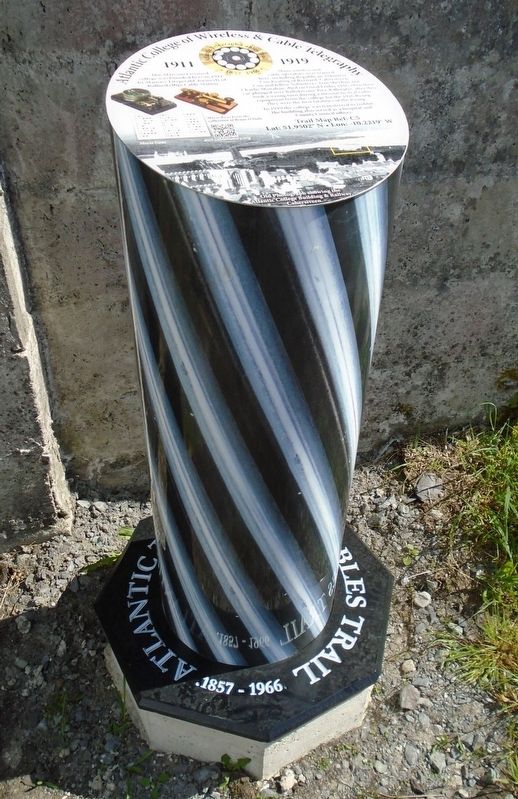
This Marconi Licensed college was founded here in 1911 by Maurice Fitzgerald, formerly of Ballinskelligs Cable Station.
Many wireless and cable operators were trained here, including Republican Volunteer Con Keating of Reenard, Cahersiveen. Con . . . — — Map (db m142388) HM
In the grounds of the O'Connell Memorial Church lies the grave of Monsignor Hugh O'Flaherty.
In Rome during World War II, he bravely organised an elaborate escape network for Allied POW's and civilians. When the l[A]lies entered Rome in 1944, . . . — — Map (db m142356) HM
In 1879 Rev. Timothy Brosnon was appointed Parish Priest of Cahersiveen and as a great admirer of Daniel O'Connell, he hoped to erect a Church that would suitably mark the centenary of his birth in 1775. Having received an audience with Pope Leo . . . — — Map (db m142353) HM
At Carhan Bridge O'Connell's home comes into view on the banks of Carhan River. He was born on August 6th 1775 at Carhan House. His parents were Morgan O'Connell and Catherine Mullane who hailed from North Cork. There were 10 siblings in the . . . — — Map (db m142604) HM
In the early 19th century Daniel O'Connell was very conscious of the need to educate the people of South Kerry and so he bought a rectors lodge in Bank Street. He invited nuns from the Presentation Order to come and set up a school to help . . . — — Map (db m142380) HM
Leaving the town park the trail proceeds to Reenrusheen road. Locally this road is known as Primrose walk. John Primrose was married to a cousin of Daniel O'Connell and he appointed Primrose as his agent in the area. O'Connell was finding it . . . — — Map (db m142474) HM
Early in the 1830's the bringing of the Railway to South Kerry was discussed. O'Connell's idea was to see the railway touching the southern coastline and to continue from Cahersiveen to Cork via Kenmare. The line between Farranfore and Killorglin . . . — — Map (db m142461) HM
Cahersiveen
Cathair saidhbhin
'The fort of Saidhbin (Little Sarah)
Saidhbin was said to be the daughter of McCarthy Mor who held the lands of Iveragh. She was given the fort and the surrounding area, on the banks of the Fertha . . . — — Map (db m142406) HM
Moving away from the Railway Bridge and the River Fertha the town park comes into view. Here was the original site of the fort of Sive which gives its name to the town of Cahersiveen. At one time there was a small village in the vicinity but very . . . — — Map (db m142468) HM
The parish of Caher was once under the instruction of this 17th century Roman Catholic Church. The graveyard around the Church has recently been restored and this peaceful area of Cahersiveen is the resting place of Morgan and Catherine . . . — — Map (db m142683) HM
The Heritage Centre came about following the defeat of the Fenians in 1867. The English government was anxious about the safety of the Valentia Atlantic cable station. A new constabulary barracks was built on the banks of the River Fertha and it . . . — — Map (db m142383) HM
"The town which climbs the mountain and looks upon the sea
in sleeping time or waking that's where I want to be."
Sigerson Clifford 1913-1985
As well as being the birthplace of Daniel O'Connell, Cahersiveen has more connections with . . . — — Map (db m142607) HM
This Parkland was donated to the people of Cahersiveen in 1997 by John (Kitty) O'Sullivan, and the development was undertaken by ACARD Ltd.
Across the Carhan River you can see the ruins of Carhan House, which on 6th August 1775 was the . . . — — Map (db m142681) HM
In 1893 the Killorglin to Valentia branch of The Great Southern and Western Railway opened. The need by local farmers and fishermen to get their produce to market in Britain was identified and the provision of a grant of £85,000, from the British . . . — — Map (db m142419) HM
Tógadh an leacht so
15 cuimhne
oifigeach agus óglach
de'n tríomhadh bhriogaid
ciarraidhe
agus na laoch eile
a fuair bas ar son
poblacht na hÉireann . . . — — Map (db m142806) HM