On South Castillo Drive (Business U.S. 1) at Cuna Street, on the right when traveling north on South Castillo Drive.
Castillo de San Marcos (English)
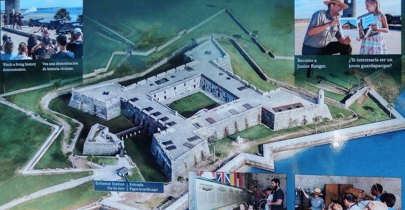
Explore the oldest masonry fort in the continental United States. For hundreds of years Castillo de San Marcos has watched over St. Augustine. From the upper gun deck, see how this massive fort guarded . . . — — Map (db m127753) HM
Near South Castillo Drive (Business U.S. 1) at Cuna Street, on the right when traveling north.
Defense in Depth (English)
Enemy troops would have encountered an obstacle course of rising slopes, low walls, and ditches before reaching the Castillo's walls. The Spanish built this extensive defensive system to help protect the fort. . . . — — Map (db m127289) HM
Near South Castillo Drive (State Road A1A) (Business U.S. 1) at Cuna Street, on the right when traveling north.
Under Continuous Attack (English)
Castillo de San Marcos has been under attack since construction began in 1672. Enemy gunfire assaulted these walls with little damage. The unrelenting onslaught of time and weather, however, are taking a . . . — — Map (db m127295) HM
Near South Castillo Drive (State Road A1A) (Business U.S. 1) at Cuna Street, on the right when traveling north.
Spanish Stronghold (English)
Castillo de San Marcos symbolizes Spain's vast New World empire. Built between 1672 and 1695, the coquina fort replaced a series of wooden forts that had protected St. Augustine for more than 100 years. . . . — — Map (db m128186) HM
Near South Castillo Drive (State Road A1A) (Business U.S. 1) at Cuna Street, on the right when traveling north.
Fortress Facelift (English)
Through treaty, Spain ceded Florida to the United States in 1821. Built to defend the city, the Castillo remained a defensive post when ownership changed. Renamed Fort Marion, the Americans made the Castillo . . . — — Map (db m127738) HM
Near South Castillo Drive (State Road A1A) (Business U.S. 1) at Cuna Street, on the right when traveling north.
Sizzling Salvo (English)
The furnace fire is blazing hot. A team of soldiers prepares hot shot to fire at wooden warships — heating cannonballs until they glow. During a naval attack, one soldier tends the coal fire and loads the . . . — — Map (db m127739) HM
Near South Castillo Drive (Business State Highway A1A) east of Orange Street, on the right when traveling north.
(English)Invincible?
After marching through miles of wilderness, the Castillo is within sight, seemingly close. But can it be taken? A treacherous obstacle course of rising slopes (glacis), low walls (covered way), and a . . . — — Map (db m127742) HM
Near South Castillo Drive (State Road A1A) (Business U.S. 1) at Cuna Street, on the right when traveling north.
Tidal Toilet (English)
This colonial restroom had a twice-daily, natural flushing system. Incoming tides filled the pit with seawater, and outgoing tides flushed waste out into the bay.
Limpiado por las mareas . . . — — Map (db m127743) HM
Near South Castillo Drive (State Road A1A) (Business U.S. 1) at Cuna Street, on the right when traveling north.
It Begins (English)
After days of watching the British prepare, bursts of smoke signal their attack from Anastasia Island. The sentry in the San Carlos watchtower in front of you yells and rings the bell. His quick action alerts the . . . — — Map (db m127744) HM
Near South Castillo Drive (State Road A1A) (Business U.S. 1) at Cuna Street, on the right when traveling north.
Crumbling Coquina (English)
Castillo de San Marcos was built using coquina, a local limestone. This porous limestone is made from millions of seashells pressed together for thousands of years. The Spanish coated the fort walls . . . — — Map (db m127745) HM
Near South Castillo Drive (State Road A1A) (Business U.S. 1) at Cuna Street, on the right when traveling north.
Multi-Use Moat (English)
It smells and sounds like a farmyard. Mooing cows, ducking chickens, and snorting pigs are penned in the moat.
The 1702 British siege made staying in town dangerous. Townspeople moved into the fort for . . . — — Map (db m127746) HM
Near South Castillo Drive (State Road A1A) (Business U.S. 1) at Cuna Street, on the right when traveling north.
Reading the Cannon (English)
Every Spanish bronze cannon and mortar has its own story. Each was individually cast, so by examining the engraved lettering and scrollwork, you can discover its origins and the Castillo's ties to Spain. Read . . . — — Map (db m127747) HM
Near South Castillo Drive (Business U.S. 1) at Cuna Street, on the right when traveling north.
Engulfed in Flames (English)
Spanish soldiers watch in horror as English troops set fire to their homes. They are helpless. The drawbridges are up. The soldier-settlers and their families are sheltered within the crowded fortress. Except . . . — — Map (db m127748) HM
Near South Castillo Drive (State Road A1A) (Business U.S. 1) at Cuna Street, on the right when traveling north.
Guarding the Back Door (English)
The Spanish built the Castillo de San Marcos along the winding, shallow channel of the Matanzas River. Any ships entering the inlet faced the fort head on, unable to deploy their guns broadside. The . . . — — Map (db m127749) HM
Near South Castillo Drive (Business U.S. 1) at Cuna Street, on the right when traveling north.
Deadly Crossfire (English)
The Spanish built the star-shaped Castillo de San Marcos in the late-1600s. The star design responded to the advent of a deadly new weapon: the cannon. The fort's complex shape meant a battery of cannons on the . . . — — Map (db m127750) HM
Near South Castillo Drive (State Road A1A) (Business U.S. 1) at Cuna Street, on the right when traveling north.
Weapons of War (English)
Touring the fort, you will see three types of artillery: mortars, howitzers, and cannons. Attackers as well as defenders had access to many types of weaponry. Each one had its own strengths and weaknesses. A . . . — — Map (db m127751) HM
Near South Castillo Drive (State Road A1A) (Business U.S. 1) at Cuna Street, on the right when traveling north.
Weapons of War (English)
Touring the fort, you will see three types of artillery: mortars, howitzers, and cannons. Attackers as well as defenders had access to many types of weaponry. Each one had its own strengths and weaknesses. A . . . — — Map (db m193851) HM
On South Castillo Drive (State Highway A1A) at Orange Street, on the right when traveling north on South Castillo Drive.
English:
Wall of Defense
The log wall at your right is a replica of the Cubo Line. The earth-and-palm-log embankment extended from the Castillo to the San Sebastian River a half-mile behind you. Two defensive walls . . . — — Map (db m128188) HM
On South Castillo Drive (State Highway A1A) at Orange Street, on the right when traveling south on South Castillo Drive.
English:
Safe Haven
Farmers bring crops and food from their fields surrounding the town. Open for trade during the day, but locked up at night, this city gate is the entrance to early 1800s civilization. Here in St. . . . — — Map (db m128083) HM
On South Castillo Drive (State Road A1A) (Business U.S. 1) near 1 South Castillo Drive, on the right when traveling north.
Saving the Seawall (English)
Hurricanes, waves, and rain have weakened the fort's historic 1840s seawall. In 2011, the National Park Service created a living seawall using coquina boulders. Silt filling the space between the two . . . — — Map (db m127740) HM