124 entries match your criteria. Entries 101 through 124 are listed.⊲ Previous 100
American Presbyterian and Reformed Historic Sites Historical Markers
The American Presbyterian and Reformed Historic Sites Registry was established by the Presbyterian Historical Society in 1973. The registry closed in 2002. To be listed in the registry, congregations submitted formal applications, which were first approved by the presbytery or classis within whose bounds the site lay, and then approved by the Society’s Historical Sites Committee. Approved sites received a metal plaque featuring John Calvin’s seal and the site’s registry number.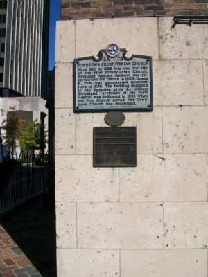
By Kathy Walker, October 20, 2009
Downtown Presbyterian Church Marker
| 101 ► Tennessee, Davidson County, Nashville, Downtown — 3A 78, 95 — Downtown Presbyterian Church — American Presbyterian and Reformed Historical Site — |
| On 5th Ave N at Church St, on the right when traveling north on 5th Ave N. | |||
| 102 ► Tennessee, Shelby County, Germantown — 386 — Fortunate Survivor — Germantown Presbyterian Church — American Presbyterian and Reformed Historical Site — |
| On Arthur Road south of Poplar Pike, on the right when traveling south. | |||
| 103 ► Tennessee, Sumner County, Gallatin — 3B 41, 176 — First Presbyterian Church — American Presbyterian and Reformed Historical Site |
| On West Main Street (Tennessee Route 25) at South Foster Avenue, on the right when traveling east on West Main Street. Reported missing. | |||
| 104 ► Texas, Travis County, Austin, University of Texas at Austin — 12743 — Austin Presbyterian Theological Seminary — American Presbyterian and Reformed Historical Site — |
| On West 27th Street near Wichita Street, on the right when traveling west. | |||
| 105 ► Utah, Salt Lake County, Salt Lake City, The Avenues — S-31, 323 — First Presbyterian Church Salt Lake City — American Presbyterian and Reformed Historical Site — |
| On South Temple Street (State Highway 186) at C Street, on the right when traveling west on South Temple Street. | |||
| 106 ► Virginia, Alexandria, Old Town — 22 — First Presbyterian Church of Alexandria — "Old Presbyterian Meeting House" — American Presbyterian and Reformed Historical Site — |
| On South Fairfax Street north of Wolfe Street, on the right when traveling south. | |||
| 107 ► Virginia, Augusta County, Fishersville — W-155 — Tinkling Spring Church — American Presbyterian and Reformed Historical Site — |
| On Tinkling Spring Road (County Route 805), on the right when traveling north. | |||
| 108 ► Virginia, Augusta County, Fort Defiance — A-118 — Augusta Stone Church — American Presbyterian and Reformed Historical Site — |
| On Lee Highway (U.S. 11) just south of County Route 616, on the right when traveling south. | |||
| 109 ► Virginia, Augusta County, Vesuvius — A-39 — New Providence Church |
| On Lee Jackson Highway (U.S. 11) at Tye River Turnpike (Virginia Route 56), on the right when traveling north on Lee Jackson Highway. Reported permanently removed. | |||
| 110 ► Virginia, Bath County, Millboro Springs — Q-13 / 148 — Windy Cove Presbyterian Church — |
| On Virginia Route 39 west of County Route 678, on the right when traveling east. | |||
| 111 ► Virginia, Campbell County, Brookneal — FR-16/210 — Hat Creek Church — American Presbyterian and Reformed Historical Site — |
| On Swinging Bridge Road (County Route 605) at Wickliffe Road (Virginia Route 40), on the right when traveling west on Swinging Bridge Road. | |||
| 112 ► Virginia, Culpeper County, Mitchells — F-25 — Mitchells Presbyterian Church — |
| On Mitchell Road (Virginia Route 652) east of Hardy Lane (Virginia Route 651), on the left when traveling east. | |||
| 113 ► Virginia, Frederick County, Winchester — 169 — Opequon Presbyterian Church — American Presbyterian and Reformed Historical Site |
| On Opequon Church Lane, in the median. Reported permanently removed. | |||
| 114 ► Virginia, Frederick County, Winchester — 169 — Opequon Presbyterian Church — |
| On Opequon Church Lane (Virginia Route 706) 0.1 miles west of Rosewood Lane, on the left when traveling west. | |||
| 115 ► Virginia, Fredericksburg — 1833 — Historic Fredericksburg Foundation — |
| On George Street at Princess Anne Street (Business U.S. 17), on the right when traveling east on George Street. | |||
| 116 ► Virginia, Rockbridge County, Collierstown — I-25 — Oxford Church — |
| On Bluegrass Trail (County Route 612) near Oxford Lane (County Route 677), on the left when traveling west. | |||
| 117 ► Virginia, Rockbridge County, Lexington — R-63 — Falling Spring Presbyterian Church — |
| On South Lee Highway (U.S. 11) at Falling Springs Road (Virginia Route 680), on the right when traveling south on South Lee Highway. | |||
| 118 ► Virginia, Rockbridge County, Lexington — L-8 — New Monmouth Church and Morrison’s Birthplace — |
| On West Midland Trail (U.S. 60) at Beatty Hollow (Virginia Route 669), on the right when traveling west on West Midland Trail. | |||
| 119 ► Virginia, Rockbridge County, Lexington — A-46 — Timber Ridge Church — |
| On Timber Ridge Road (Virginia Route 716) at Sam Houston Way (Virginia Route 785), on the right when traveling east on Timber Ridge Road. | |||
| 120 ► Virginia, Rockbridge County, Raphine — New Providence Presbyterian Church — |
| On Brownsburg Turnpike (Virginia Route 252) just south of New Providence Road, on the right when traveling south. | |||
| 121 ► Virginia, Stafford County, Fredericksburg — E-126/129 — Hartwood Presbyterian Church — American Presbyterian and Reformed Historical Site — |
| On Hartwood Church Road (County Route 705), on the right when traveling west. | |||
| 122 ► Virginia, Winchester — 132 — Old Stone Presbyterian Church — Erected 1788 — American Presbyterian and Reformed Historical Site — |
| On East Piccadilly Street at North East Lane, on the left when traveling east on East Piccadilly Street. | |||
| 123 ► Washington, King County, Seattle, Capitol Hill — 252 — The Reverend George Whitworth Grave — American Presbyterian and Reformed Historical Site — |
| Near 15th Avenue East south of East Garfield Street. | |||
| 124 ► Wisconsin, Marquette County, Endeavor — 102 — The Wee White Kirk — American Presbyterian and Reformed Historical Site — |
| On 13th Road, 0.1 miles north of County Highway O, on the left when traveling north. | |||
124 entries matched your criteria. Entries 101 through 124 are listed above. ⊲ Previous 100