On South Main Street just north of West 3rd Street, on the left when traveling north.
In 1838, McKendree Moore, with his father, Enoch Moore, owned a mercantile store here, which carried on until the death of McKendree Moore in 1840. The Moore family was one of Waterloo's first settlers. Enoch Moore, born in 1783 in the blockhouse at . . . — — Map (db m140341) HM
On South Main Street at West Mill Street, on the left when traveling north on South Main Street.
This building as it stands today sits on combined lots, which were originally the sites of a rock residence and a butcher shop, Theodore Ruch's meat market. The meat market was a family operated business in the 1880's ran by prominent butchers . . . — — Map (db m140469) HM
On South Main Street just south of West 3rd Street, on the right when traveling south.
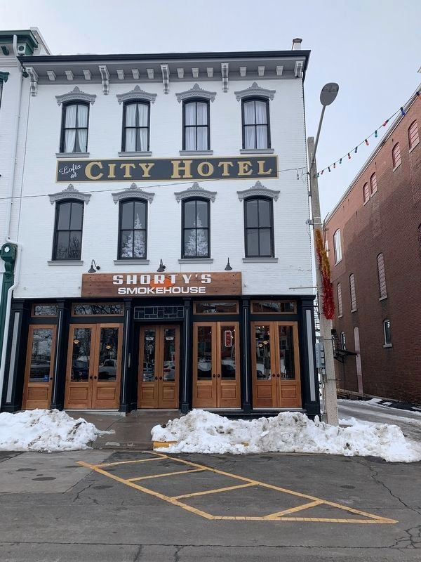
213 South Main Street
Became the headquarters of Harrisonville Telephone Company in 1905 when the Company moved in, occupying one-fourth of the building. At that time, the remaining space was apartments.
As Harrisonville . . . — — Map (db m144220) HM
On Main Street south of West 3rd Street, on the right when traveling south.
In 1818 George Forquer purchased and, along with Daniel P. Cook, began laying out the lots that would become known as Original Waterloo or Old Town Waterloo. They immediately sold lot 82 in Block 11 to Alexander Wells for $20. It stayed in the . . . — — Map (db m140426) HM
On North Main Street north of Flower Street, on the left when traveling north.
The first brewery established in Waterloo, the Koechel brewery, was built at this location in 1847 by john and Elizabeth Koechel.
It is believed to have been a wooden structure which was replaced by a brick building in 1852. John Koechel ran . . . — — Map (db m140421) HM
On South Main Street at West 3rd Street, on the right when traveling south on South Main Street. Reported missing.
In 1886, Peter Feller bought a wooden structure for $2,500 located on lots 13, 14 and 15 of block 19, which would later be addressed as 141 South Main Street, and known as the Southern Hotel. In 1892, the hotel was rebuilt of brick and a tavern . . . — — Map (db m206201) HM
On 3rd Street just west of South Market Street, on the left when traveling west.
The land on which Hopskeller now stands dates back to March, 1816, when William Lemon purchased nearly 255 acres at a cost of $2 per acre. This land encompassed all modern-day downtown Waterloo.
For unknown reasons, in January of 1817 (only ten . . . — — Map (db m140337) HM
On South Main Street north of East 4th Street, on the right when traveling north.
This historic building, known officially as Tax Lot 2 in Block 8 of
Waterloo, dates back to the year 1845 and has served many purposes
throughout the years. Unfortunately, we have no record of what it was
used for in its earliest years, other . . . — — Map (db m143251) HM
John Coleman purchased three lots (115, 117, and 119 East Mill) in 1834. The present building at 115 was built before the Civil War. In 1862 Coleman sold the property to William Hursey who later sold it to Paul C. Brey, who was a German native born . . . — — Map (db m140459) HM
On South Main Street just north of East 4th Street (Illinois Route 156), on the left when traveling north.
The Garretson Home was built in 1852 as a family home in the Italianate style, by William C. Garretson, a prominent figure in the history of Monroe County. William Garretson was a direct relative of James Garretson, one of the founding fathers of . . . — — Map (db m140387) HM
On South Main Street at West 3rd Street, on the left when traveling north on South Main Street.
The Küenster Building is named after its builder, Hubert Küenster, who built it as home to his pharmacy in 1871. Küenster was appointed as a Postmaster in 1865, so there is belief that the Post Office was also in this building at one point in time, . . . — — Map (db m140348) HM
On South Main Street just north of West 3rd Street, on the left when traveling north.
Hubert Küenster immigrated to America from Germany in May 1852. He came to St. Louis, where he was a clerk in Dr. Berghoff’s drug store for a year. Some of his countrymen were residents in the neighborhood of Waterloo, and at their request, Küenster . . . — — Map (db m143986) HM
Near Park Street (Route 156) just east of South Liberty Street, on the left when traveling east.
Since the late 1800’s, citizens have worked to provide the community of Waterloo, Illinois, with a public library to serve as a cultural center. In 1892, Henry and Mary Talbott donated their personal collection of over 3,000 books and periodicals to . . . — — Map (db m144987) HM
On South Main Street just south of West 3rd Street, on the left when traveling south.
Elizabeth and William Sinnhold were the first owners of the land of which the Odd Fellows building sits today. In 1875, M.C. Rodenberger and Wm. Kestner, established M.C. Rodenberger and Company, which made and sold marble and granite monuments, . . . — — Map (db m140519) HM
On North Main Street just north of Flower Street, on the right when traveling north.
This property, located at 116 North Main Street, dates back to the year 1843. Not much is known about its original owners, John H. and Mariah Pirtle. They sold the building to Thomas Singleton on June 13, 1843 for two hundred and thirty-five . . . — — Map (db m148321) HM
On South Main street just south of West Mill Street, on the right when traveling south.
The Pluth Building was originally constructed in 1885 as a two-story building which featured a French-style mansard roof. The roof reached the height of the current building's third floor. Original sketches of the building plans detail the upstairs . . . — — Map (db m140350) HM
On South Church Street just south of West Mill Street, on the left when traveling south.
The Schmitt-Nobbe Building has been a grocery store for the bulk of its existence. In 1941 Ambrose Schmitt inherited the property, along with several other properties, from his wife Annie Schmitt upon her death. Ambrose decided to leave it all to . . . — — Map (db m140381) HM
On South Main Street just north of West 3rd Street, on the left when traveling north.
Records dating back to 1837 tell us that David Ditch, an early pioneer of Waterloo, was the original owner of this property. David Ditch is known for operating Waterloo’s first hotel and bar, called Ditch Tavern, which was about 2 blocks north of . . . — — Map (db m148323) HM
On East Mill Street, on the right when traveling south on East Mill Street.
Before 1830, John Coleman erected a large windmill at the corner of Main and Mill where this building stands today. He also owned a mill next door. The mill was changed into an ox-mill in 1837 and destroyed by fire in 1857, when it was a steam . . . — — Map (db m140392) HM
On South Main Street just south of West Mill Street, on the left when traveling north.
This property, 107 South Main Street, is officially known as Tax Lot 11 in Block 12 of Old Town, now City of Waterloo, Monroe County, Illinois. Property deeds date back to 1867, when its first owners, John and Mary Harms sold the property to . . . — — Map (db m156248) HM
On West 4th Street (Illinois Route 156) just east of South Church Street (Illinois Route 156), on the left when traveling west.
The Waterloo City Hall is situated on Lots 75 and 76 at 100 West Fourth Street in the southerly block between Main Street and Church Street.
In 1816, George Forquer purchased a tract of land that is now part of the City of Waterloo. Forquer and . . . — — Map (db m144219) HM