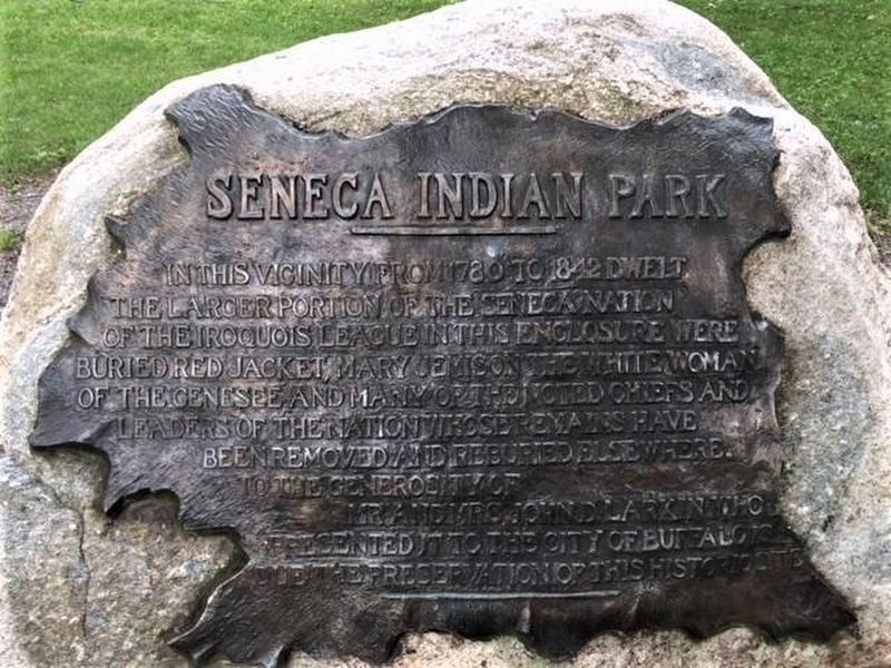
In this vicinity from 1780 to 1842 dwelt the larger portion of the Seneca Nation of the Iroquois League. In this enclosure were buried Red Jacket, Mary Jemison the white woman of the Genesee and many of the noted chiefs and leaders of the nation . . . — — Map (db m232547) HM
On Letchworth Park Road, 0.2 miles north of Degolyer Road (County Route 41), on the left when traveling north.
South border of reservation
set aside for Mary Jemison
White Woman of the Genessee
during the Big Tree Treaty
of 1797 at Geneseo N.Y.
William G. Pomeroy Foundation 2014
— — Map (db m118846) HM
On New York State Route 39 at milepost 12.5,, 2 miles north of Sawyers Road, on the left when traveling north.
Near this spot, Robert Whaley built the first log cabin in the Town of Castile in 1808. To this cabin, in 1823, came Mary Jemison, famed "White Woman of the Genesee," to tell her story. Captured by the Indians in 1758, when 15 years old, she . . . — — Map (db m76346) HM
Near Council Ground Access Road, 0.2 miles west of Park Road.
Mary Jemison (1743-1833) was born during a voyage from Ireland to the United States [sic]. Captured during the French and Indian War, she was adopted into the Seneca Nation and chose to remain a Seneca, marrying and raising a family in the Genesee . . . — — Map (db m76358) HM
This log house which originally stood on the Gardeau Flats by the Genesee River was built about 1800 by Mary Jemison, "The White Woman of the Genesee," for her second daughter, Nancy. In a nearby cabin, also built by her, she lived about 35 years. . . . — — Map (db m76137) HM
Near Council Grounds Access Road, 0.2 miles west of Park Road.
[front]
To the Memory of Mary Jemison, Whose home during more than seventy years of a life of strange vicissitude was among the Senecas upon the banks of this river, and whose history, inseparately connected with that of this valley has caused . . . — — Map (db m76359) HM
Inspiration Point is rich in history and natural splendor. The spectacular view was once enjoyed by the Seneca Indians and by Mary Jemison, the White Woman of the Genesee.
Upon arrival of the pioneers in the early 1800's, the falls and forests . . . — — Map (db m76114) HM
On Letchworth Park Road, 0.9 miles south of Schenck Road (County Route 18), on the left when traveling south.
North border of reservation set aside for Mary Jemison White Woman of the Genessee during the Big Tree Treaty of 1797 at Geneseo N.Y. — — Map (db m118841) HM
On South High Street at Chambersburg Street, on the right when traveling south on South High Street.
Arendtsville serves as serves as a Gateway to South Mountain and its earliest history was connected to the Native American tribes who hunted its rich forestlands. Various artifacts and arrowheads can still be found along local streams in the . . . — — Map (db m159861) HM
On Lincoln Highway (U.S. 30) at Buchanan Valley Road (State Route 234), on the right when traveling east on Lincoln Highway.
In 1758, during the French & Indian War, a party of French soldiers and Shawnee took Mary Jemison from her home 3 miles north of here. Although most of her family and neighbors were killed, Mary was adopted by two Seneca women. Jemison lived with . . . — — Map (db m11620) HM
On Church Road south of Buchanan Valley Road, on the right when traveling north.
During the French and Indian War, Mary Jemison was kidnapped from this valley on April 5, 1758 by a band of Frenchmen and Shawnee Indians. Taken to Fort Duquesne, now Pittsburgh, she was adopted by Seneca Indians who named her "Deh-Ge-Wa-Nus." In . . . — — Map (db m121191) HM
On Charmian Road just east of Buchanan Trail East (Pennsylvania Route 16), on the right when traveling east.
Before the French and Indian War in 1754, lands west of South Mountain was considered a wilderness. With the outbreak of war, several settlements in this area were raided by the Indians.
In 1756, two Indian raids occurred, with one man taken . . . — — Map (db m192351) HM