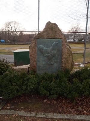
To commemorate the birthplace of the Rhode Island Red breed of fowl which originated near this location Red fowls were bred extensively by the farmers of this district and later named "Rhode-Island-Reds" and brought into National prominence by the . . . — — Map (db m56093) HM
In this house the British General Prescott was taken prisoner on the night of July 9, 1777 by Lieutenant-Colonel Barton of the Rhode Island Line. — — Map (db m48060) HM
Built 1777 by the English for the defence of Newport The gift of ---------- W. W. Sherman J. N. Brown H. Brown F. S. Barker S. P. Barker — — Map (db m48062) HM
Imagine this twenty acre fort filled to capacity: 2,400 soldiers here to defend Newport with 468 cannon sited along the most probable attack routes. Though designed to house an imposing force, Fort Adams was normally garrisoned with several . . . — — Map (db m48125) HM
This was the home of Mr. Smith until his death in 1886. As a Real Estate Broker he helped to develop the land along Bellevue Avenue.
This property has been
placed on the
National Register
of Historic Places
by the United States . . . — — Map (db m223109) HM
The Bay Islands Park, managed by the Rhode Island Department of Environmental Management, consists of nine sites that extend from Patience Island in the upper bay to Beavertail and Brenton Point overlooking Rhode Island Sound. Each of the nine . . . — — Map (db m48451) HM
Bells have long been a symbol of significance in maritime history. They are used to note the arrival of notable guests, mark the daily routine aboard naval vessels, and serve as warning signals in the fog. — — Map (db m223194) HM
“Fort Adams . . . often was dubbed the country club of the army, especially by those officers and enlisted men who were assigned to it after duty in foreign areas. And its peacetime background was dotted with stories of high society and . . . — — Map (db m48233) HM
1. Ferry Increasing numbers of Rhode Islanders board cruise boats and ferries to get out of the Bay. These ferries are reminiscent of the pleasure steamboats that were so common on Narragansett Bay one hundred years ago. 2. Fast . . . — — Map (db m56460) HM
In Honor of Ernest Coggeshall, Jr. 9/2/15 – 4/27/95 Capt. Joseph X. “Jay” O’Brien, Jr. 4/21/54 – 12/16/90 Dad, Mom and Family [ Right Side of Monument : ] James Wah Gin Wong 1918 – 1993 Stephen Joseph . . . — — Map (db m48922) HM
Governor Philip W. Noel Lt. Governor J. Joseph Garrahy Director Dennis J. Murphy, Jr. Sen. Erich A. O’D. Taylor, President Sen. Robert J. McKenna Mayor Humphrey J. Donnelly, III Committee Chairman James Thomson Douglas Agnes R. Curtis . . . — — Map (db m48973) HM
U.S. army officer, Joseph G. Totten superintended the construction of Fort Adams beginning in 1825. He oversaw all details of construction until 1838, when he was appointed as the first Chief Engineer of the newly created Army Corps of Engineers. [ . . . — — Map (db m48181) HM
This property has been
placed on the
National Register
of Historic Places
by the United States
Department of the Interior
Captain Phillips Hosue
Built cir 1730
Bought in 1806 by
Samuel Phillips, Mariner
Moved . . . — — Map (db m223237) HM
The late 19th century saw revolutionary changes in both weapons and strategies of defense. Steam powered ships with high velocity naval guns could now bring the walls down and rendered forts obsolete. To remedy the risk, Fort Adams expanded outside . . . — — Map (db m48230) HM
The buildings surrounding Chateau-sur-Mer capture the spirit of Newport in the High Victorian era. This block preserves one of the greatest concentrations of Victorian architecture and landscape design in Newport from the period 1850 to 1890. The . . . — — Map (db m48609) HM
Christopher Ellery House
has been placed on the
National Register
of Historic Places
by the United States
Department of the Interior
c 1750 — — Map (db m223142) HM
Clarke Cooke
House
circa 1780
This property has been
placed on the
National Register
of Historic Places
by the United States
Department of the Interior — — Map (db m223200) HM
Shore Restoration and Protection
Newport, Rhode Island
1984-1985
Funded by the National Park Service-
Land and Water Conservation Fund,
The State of Rhode Island and
The City of Newport
Patrick G. Kirby, Mayor
City Council Members . . . — — Map (db m115160) HM
Home of the artist Michel Felice Corne who introduced the tomato into this country.
Michele Felice Cornè House
2 Corne Street
has been placed on the
National Register
of Historic Places
by the United States
Department . . . — — Map (db m223150) HM
Think about how difficult a land attack against Fort Adams would be. First, you would have to capture the Redoubt, located a quarter mile to the south. You would then have to charge up the sloping glacis to the Southern front. Finally, you would . . . — — Map (db m48138) HM
During the 19th century, Newport was the only deep water harbor between New York and Boston which could serve as a base for a large fleet of warships. Fort Adams was located at a crucial point where it could prevent the entry of enemy warships into . . . — — Map (db m48129) HM
During the 19th century, Newport was the only deep water harbor between New York and Boston which could serve as a base for a large fleet of warships. Fort Adams was located at a crucial point where it could prevent the entry of enemy warships into . . . — — Map (db m48235) HM
Equality Park is a triangular shaped park bounded by Equality Park West, Equality Park Place and Broadway. It is one of three Broadway Parks, the other two being on the east side of Broadway. These two parks are both titled Congdon Park and . . . — — Map (db m223286) HM
On this old common the boats of H.M.S. Liberty were burned on July 19, 1769 by the citizens of Newport, who had previously fired upon and destroyed the sloop. This was the first overt act of violence to Great Britain in America. — — Map (db m223295) HM
In loving memory of the 217 family members and friends lost on EqyptAir Flight 990 ca 60 miles south of Nantucket Island October 31, 1999 ♦ ♦ ♦ May God’s eternal light shine on them ♦ ♦ ♦ “They are not . . . — — Map (db m48925) HM
Statesman ~ Legislator Teacher ~ Patriot 1st Chairman – Fort Adams Foundation May 18, 1972 A dynamic force for the preservation of Fort Adams with a determination as unyielding as this granite block. — — Map (db m48444) HM
History you can Touch Explore the casemates where the big guns once roared. Discover how 8 soldiers worked together to load and fire each cannon. Step into the quarters where the soldiers and their families lived. Ascend to the scenic . . . — — Map (db m48249) HM
History you can Touch Explore the casemates where the big guns once roared. Discover how 8 soldiers worked together to load and fire each cannon. Step into the quarters where the soldiers and their families lived. Ascend to the scenic . . . — — Map (db m48276) HM
History you can Touch Explore the casemates where the big guns once roared. Discover how 8 soldiers worked together to load and fire each cannon. Step into the quarters where the soldiers and their families lived. Ascend to the scenic . . . — — Map (db m48284) HM
To honor the members of the Fort Adams Foundation May 4, 1976 Governor Philip W. Noel Lt. Governor J. Joseph Garrahy Director Dennis J. Murphy, Jr. George E. Howarth, 1st Commandant Sen. Erich A. O’D. Taylor, President Sen. Robert J. McKenna Rep. . . . — — Map (db m48971) HM
Picture this space in action as gun crews drilled in live fire exercises – the booming noise of cannon, the thick smoke, the smell of burnt powder, and the shouting of commands. This casemate, a chamber with openings for cannons, could house . . . — — Map (db m48333) HM
In 1639, Helen and Nicholas Easton, John Clarke, William Coddington and others left Portsmouth, the settlement founded in 1638 by Anne Hutchinson and others on the northern end of Aquidneck Island. They came south and founded Newport. Newport’s . . . — — Map (db m48498) HM
Site of First Catholic Church in Rhode Island
1828
Final resting place of many of Newport's earliest Irish residents.
The oldest marked burial is 1830, the most recent 1853.
Although Rhode Island is well known for its . . . — — Map (db m223110) HM
has been designated a Registered National Historic Landmark Under the provisions of the Historic Sites Act of August 21, 1935 this site possesses exceptional value in commemorating and illustrating the history of the United States U.S. . . . — — Map (db m48093) HM
In Memory Of
J. Joseph M. Martin
1874 - 1933
Veteran of Spanish - American War
Company F. 1st Rhode Island U.S. Volunteer Infantry
Member Of
1901 - Common Council - 1907
1907 - Representative Council - 1916
1917 - Board of . . . — — Map (db m88700) HM WM
This property has been placed on the National Register of Historic Places The James Nicoll House c. 1750 by the United States Department of the Interior — — Map (db m48687) HM
I did not have far or long to look, because, being the junior officer of the garrison I could displace no other, and besides, there was but one casemate available for me to choose from . . . A good sweeping and a little glazing of broken . . . — — Map (db m48130) HM
In memory of Maj. Gen. Isaac Ingalls Stevens Born in Andover, Mass. Who gave to the service of his country a quick and comprehensive mind, a warm and generous heart, a firm will and a strong arm, and who fell while rallying his command with the flag . . . — — Map (db m48625) HM
Mary Ferrazzoli (1928-1994) was the visionary leader who founded the Friends of the Waterfront in 1982. She vigorously championed public access and stood firmly opposed to the commercial overdevelopment of the Newport waterfront blocking public . . . — — Map (db m189622) HM
[ South side : ] Near this spot the French army of 6000 men led by General Rochambeau our allies in the War for Independence first set foot upon American soil July XIII 1780 [ East side : ] I welcome the news of your arrival A . . . — — Map (db m49054) HM
This piece of land was given to the town of Newport by Major Nathaniel Sheffield and Mr. Daniel Thurston as common land to be used as a mustering place for the militia. This marker dedicated by the Artillery Company of Newport on their 250th year . . . — — Map (db m48096) HM
Capt. Trey Topping July 25, 1967 Capt. Jason Franks February 10, 1973 Christine Grinavic January 21, 1981 Rhiannon Borisoff July 26, 1984 Now they are sailing alongside their God with fair winds, following seas, and the warm sun shining on their . . . — — Map (db m48617) HM
Newport's location is a fisherman's dream. Easy access to Narragansett Bay and "out front" (the open Atlantic Ocean), puts hundreds of delicious species within reach of this well-protected harbor.
With origins dating back to the 17th . . . — — Map (db m223224) HM
You are standing at the entrance to the Newport Casino, a National Historic Landmark that now houses the International Tennis Hall of Fame.
The Casino was built in 1880 as a social club for Newport's wealthy summer residents. The name of the . . . — — Map (db m115200) HM
Newport Harbor has been a center of commerce and industry since the days Narragansetts and Wampanoags, Native Americans, fished the waters of this bay. The first European explorer was Giovanni da Verrazzano, an Italian who sailed for the King of . . . — — Map (db m189621) HM
has been designated a Registered National Historic Landmark Under the provisions of the Historic Sites Act of August 21, 1935 this site possesses exceptional value in commemorating and illustrating the history of the United States U.S. . . . — — Map (db m48092) HM
At the age of twenty seven years he achieved the Victory of Lake Erie September 10, 1816 [ Right of Monument : ] Born in South Kingstown, R.I. August 23, 1785 Died at Port Spain, Trinidad August 23, 1819 Aged 34 years [ Back of . . . — — Map (db m48630) HM
Pelham Street runs along the southern edge of colonial Newport and is the location of houses built in the 18th and 19th centuries. It is named for the Pelham family of Newport which is related to the British Prime Minister Henry Pelham. In 1810, . . . — — Map (db m223154) HM
Perry Mill
built in 1835
has been placed on the
National Register
of Historic Places
by the United States
Department of the Interior — — Map (db m223191) HM
“This monument is a gift to the people of the United States of America, from the Rhode Island General Assembly in conjunction with the National Committee of the Commemorations of the Discoveries of Portugal and commissioned under the . . . — — Map (db m48088) HM
The monument before you honors the Portuguese navigators of the Golden Age of Maritime Exploration, which spanned from the early 1400’s to the late 1500’s. During this era, Portugal was the forerunner in maritime exploration – both coasts of . . . — — Map (db m48378) HM
Queen Anne Square lies within the area of some of Newport's earliest settlement. Prominent at the head of the park lies Trinity Church, a Newport icon and one of Newport's oldest congregations. Formed in 1698 as an Anglican congregation of . . . — — Map (db m223215) HM
has been designated a
Registered National
Historic Landmark
under the provisions of the
Historic Sites Act of August 21, 1935
This site possesses exceptional value
in commemorating and illustrating
the history of the United . . . — — Map (db m198206) HM
While Fort Adams was in active service from 1842 to 1950, the United States flag flew proudly over the ramparts. When the last U.S. Army unit departed our flag was hauled down, and there was no longer a flagpole within the Fort proper. During 2001 . . . — — Map (db m48246) HM
Since 1775 the United States Marines have served our nation in peace and war ------------------- Semper Fidelis These marines continue to be true to these words. Cpl. Rick R. Crudale – West Warwick • Sgt. Timothy R. Giblin – North . . . — — Map (db m48622) HM
18th century, Newport was a major hub for the northern 'triangle slave trade'. Enslaved Africans, traded for rum, arrived and departed from Bowen's Wharf, in sailing ships and labored as dock workers, shipbuilders, sailors, caulkers, sailmakers, . . . — — Map (db m223202) HM
In memory of Rhode Island State licensed pilots serving the Brenton Reef Pilot Station located 4 miles due south. Capt. John J. Neary, Jr. Serving 1955 – 1997 Capt. Walter H. Fricke Serving 1971 – 1989 Capt. Carl T. Ohrn Serving . . . — — Map (db m48988) HM
[ Left Marker : ]On June eighteenth, 1781, General Rochambeau left Newport with his army to join the American forces on the Hudson, and on August nineteenth, 1781, the combined armies under command of General Washington began their . . . — — Map (db m48054) HM
667 entries matched your criteria. Entries 101 through 200 are listed above. ⊲ Previous 100 — Next 100 ⊳