667 entries match your criteria. Entries 101 through 200 are listed.⊲ Previous 100 — Next 100 ⊳
Historical Markers and War Memorials in Rhode Island
By Bryan Simmons, February 1, 2012
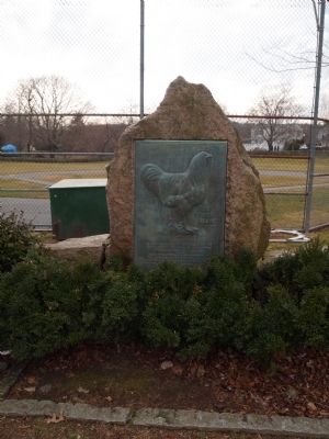
Rhode Island Red Marker
| 101 ► Rhode Island, Newport County, Little Compton, Adamsville — Rhode Island Red — |
| On Main Street at Adamsville Road on Main Street. | |||
| 102 ► Rhode Island, Newport County, Middletown — Prescott’s Headquarters — |
| On West Main Road (Rhode Island Route 114), on the right when traveling north. | |||
| 103 ► Rhode Island, Newport County, Middletown, Newport East — Green End Fort — |
| On Vernon Avenue east of Boulevard, on the left when traveling east. | |||
| 104 ► Rhode Island, Newport County, Newport — 1 Elm Street — |
| On Elm Street at Cross Street, on the right when traveling west on Elm Street. | |||
| 105 ► Rhode Island, Newport County, Newport — 45 Elm Street — |
| On Elm Street east of Washington Street, on the right when traveling west. | |||
| 106 ► Rhode Island, Newport County, Newport — 77 Division Street — |
| On Division Street south of Church Street, on the right when traveling south. | |||
| 107 ► Rhode Island, Newport County, Newport — 79 Thames Street — |
| On Thames Street south of Coddington Street, on the right when traveling south. | |||
| 108 ► Rhode Island, Newport County, Newport — A Giant Among Forts — |
| Near Fort Adams Drive, on the left when traveling north. | |||
| 109 ► Rhode Island, Newport County, Newport — Alexander Jack Jr. House — c.1811 — NRF Founded by Doris Duke 1968 — |
| On Spring Street. | |||
| 110 ► Rhode Island, Newport County, Newport — Alfred Smith House — Circa 1845 — 12 Mount Vernon Street — |
| On Mount Vernon Street north of Barney Street, on the right when traveling south. | |||
| 111 ► Rhode Island, Newport County, Newport — Ann Webber House — c. 1794 — NRF Founded by Doris Duke 1968 — |
| On Washington Street south of Bridge Street, on the left when traveling south. | |||
| 112 ► Rhode Island, Newport County, Newport — Bay Islands Park — |
| Near Fort Adams Drive, on the left when traveling north. | |||
| 113 ► Rhode Island, Newport County, Newport — Bells — |
| On Commercial Wharf at America's Cup Avenue (Rhode Island Route 138A), on the left when traveling west on Commercial Wharf. | |||
| 114 ► Rhode Island, Newport County, Newport — Between the Wars — |
| Near Fort Adams Drive, on the left when traveling north. | |||
| 115 ► Rhode Island, Newport County, Newport — Billy Bottomore — Confectioner — circa 1750 — |
| On Mill Street west of Division Street, on the left when traveling east. | |||
| 116 ► Rhode Island, Newport County, Newport — Boats of the Bay — |
| 117 ► Rhode Island, Newport County, Newport — Bowen's Wharf — |
| On America's Cup Avenue (Rhode Island Route 138A) at Bowen's Wharf, on the right when traveling south on America's Cup Avenue. | |||
| 118 ► Rhode Island, Newport County, Newport — Bowen's Wharf — |
| On America's Cup Avenue (Rhode Island Route 138A) at Bowen's Wharf on America's Cup Avenue. | |||
| 119 ► Rhode Island, Newport County, Newport — Brenton Point Maritime Memorial — |
| On Ocean Drive, on the left when traveling south. | |||
| 120 ► Rhode Island, Newport County, Newport — Brenton Point State Park — |
| On Ocean Drive, on the left when traveling south. | |||
| 121 ► Rhode Island, Newport County, Newport — Buffum-Redwood House — c. 1700 enlarged 1740 — NRF Founded by Doris Duke 1968 — |
| On Spring Street. | |||
| 122 ► Rhode Island, Newport County, Newport — Building a Fortress — |
| Near Fort Adams Drive, on the left when traveling north. | |||
| 123 ► Rhode Island, Newport County, Newport — Buliod-Perry House — c. 1750 — NRF Founded by Doris Duke 1968 — |
| On Touro Street at Touro Ct., on the right when traveling east on Touro Street. | |||
| 124 ► Rhode Island, Newport County, Newport — Cap't George Buckmaster House — c. 1768 — NRF Founded by Doris Duke 1968 — |
| On Division Street. | |||
| 125 ► Rhode Island, Newport County, Newport — Capt. George Mowat House — c. 1786 — 83 Division Street — |
| On Division Street south of Church Street, on the right when traveling south. | |||
| 126 ► Rhode Island, Newport County, Newport — Capt. John Wanton House — moved 1930 — ca. 1771 — |
| On Washington Street at Bridge Street, on the left when traveling south on Washington Street. | |||
| 127 ► Rhode Island, Newport County, Newport — Cap't. William Read House — 1740 — NRF Founded by Doris Duke 1968 — |
| On Thames Street at Cozzens Court, on the left when traveling south on Thames Street. | |||
| 128 ► Rhode Island, Newport County, Newport — Captain John Warren House — Built 1737 — |
| On Washington Street near Elm Street, on the right when traveling south. | |||
| 129 ► Rhode Island, Newport County, Newport — Captain Phillips House — 42 Elm Street — |
| On Elm Street west of 2nd Street, on the left when traveling west. | |||
| 130 ► Rhode Island, Newport County, Newport — Changing Role of the Fort — |
| Near Fort Adams Drive, on the left when traveling north. | |||
| 131 ► Rhode Island, Newport County, Newport — Charlotte Burleigh House — 71 Touro Street — |
| On Touro Street east of Spring Street, on the right when traveling east. | |||
| 132 ► Rhode Island, Newport County, Newport — Chateau-sur-Mer & Its Neighbors: A Victorian District Preserved — |
| On Bellevue Avenue at Leroy Avenue, on the left when traveling south on Bellevue Avenue. | |||
| 133 ► Rhode Island, Newport County, Newport — Christopher Ellery House — ca. 1750 — 80 Division Street — |
| On Division Street south of Church Street, on the left when traveling south. | |||
| 134 ► Rhode Island, Newport County, Newport — Civil War Memorial — |
| On Broadway south of Calvert Street, on the right when traveling north. | |||
| 135 ► Rhode Island, Newport County, Newport — Clarke Cooke House — 26 Bannister's Wharf — |
| On Bannister's Wharf west of America's Cup Avenue (Rhode Island Route 138A), on the left when traveling west. | |||
| 136 ► Rhode Island, Newport County, Newport — Cliff Walk — Developed by estate owners during Newport’s Gilded Age, 1880-1920 — Designated National Historic Walking Trail 1976 — |
| Near Memorial Boulevard (Rhode Island Route 138A) near Eustis Avenue, on the right when traveling east. | |||
| 137 ► Rhode Island, Newport County, Newport — Cliff Walk — |
| On Narragansett Ave. | |||
| 138 ► Rhode Island, Newport County, Newport — Corné House — 2 Corne Street — Rhode Island Tercentenary 1636 - 1936 — |
| On Corne Street at Mill Street, on the left when traveling south on Corne Street. | |||
| 139 ► Rhode Island, Newport County, Newport — David Braman House — 1706 — NRF Founded by Doris Duke 1968 — |
| On Thames Street north of Sanford Street, on the right when traveling north. | |||
| 140 ► Rhode Island, Newport County, Newport — Defending From Land Assault — |
| Near Fort Adams Drive, on the left when traveling north. | |||
| 141 ► Rhode Island, Newport County, Newport — Defending Narragansett Bay — |
| Near Fort Adams Drive, on the left when traveling north. | |||
| 142 ► Rhode Island, Newport County, Newport — Defending Narragansett Bay — |
| Near Fort Adams Drive, on the left when traveling north. | |||
| 143 ► Rhode Island, Newport County, Newport — Eisenhower Park — |
| On Washington Square, on the left when traveling east. | |||
| 144 ► Rhode Island, Newport County, Newport — Elisha Johnson House — c. 1750 — 86 Spring Street — |
| On Spring Street. | |||
| 145 ► Rhode Island, Newport County, Newport — Equality Park — |
| On Equality Park Place at Broadway, on the right when traveling north on Equality Park Place. | |||
| 146 ► Rhode Island, Newport County, Newport — Equality Park — |
| On Equality Park West at Gould Street, on the left when traveling south on Equality Park West. | |||
| 147 ► Rhode Island, Newport County, Newport — EqyptAir Flight 990 Memorial — |
| On Ocean Drive, on the left when traveling south. | |||
| 148 ► Rhode Island, Newport County, Newport — Erich A. O’D. Taylor — |
| On Fort Adams Drive, on the left when traveling north. | |||
| 149 ► Rhode Island, Newport County, Newport — First Street in the United States to Be Lighted with Gas — Rhode Island Tercentennial — 1636 - 1936 — |
| On Pelham Street at Thames Street, on the left when traveling west on Pelham Street. | |||
| 150 ► Rhode Island, Newport County, Newport — Fort Adams — |
| On Fort Adams Drive when traveling north. | |||
| 151 ► Rhode Island, Newport County, Newport — Fort Adams — |
| On Fort Adams Drive, on the left when traveling north. | |||
| 152 ► Rhode Island, Newport County, Newport — Fort Adams — |
| Near Fort Adams Drive, on the left when traveling north. | |||
| 153 ► Rhode Island, Newport County, Newport — Fort Adams Foundation — |
| Near Fort Adams Drive, on the left when traveling north. | |||
| 154 ► Rhode Island, Newport County, Newport — Gideon Cornell House — c. 1765 — NRF Founded by Doris Duke 1968 — |
| On Division Street just south of Touro Street when traveling south. | |||
| 155 ► Rhode Island, Newport County, Newport — Going Great Guns — |
| Near Fort Adams Drive, on the left when traveling north. | |||
| 156 ► Rhode Island, Newport County, Newport — Governor Gideon Wanton House — 11 Cross Street — Newport National Historic Landmark District — |
| On Cross Street at Elm Street on Cross Street. | |||
| 157 ► Rhode Island, Newport County, Newport — Great Friends Meeting House — |
| On Marlborough Street at Farewell Street, on the left when traveling east on Marlborough Street. | |||
| 158 ► Rhode Island, Newport County, Newport — Hathaway-Macomber House — c. 1715 — NRF Founded by Doris Duke 1968 — |
| On Thames Street south of Cozzens Court, on the right when traveling south. | |||
| 159 ► Rhode Island, Newport County, Newport — Historic Barney Street Cemetery — |
| On Mount Vernon Street north of Barney Street, on the right when traveling south. | |||
| 160 ► Rhode Island, Newport County, Newport — Howland House — c. 1721 — NRF Founded by Doris Duke 1968 — |
| On Bridge Street west of Thames Street, on the left when traveling west. | |||
| 161 ► Rhode Island, Newport County, Newport — Hunter House — 54 Washington Street — |
| On Washington Street at Elm Street, on the right when traveling south on Washington Street. | |||
| 162 ► Rhode Island, Newport County, Newport — Isaac Dayton House — c. 1725 — NRF Founded by Doris Duke 1968 — |
| On Washington Street south of Bridge Street, on the left when traveling south. | |||
| 163 ► Rhode Island, Newport County, Newport — J. Joseph M. Martin — |
| On Old Fort Road at Carroll Avenue, on the left when traveling south on Old Fort Road. | |||
| 164 ► Rhode Island, Newport County, Newport — Jail House Inn — 13 Malborough Street — |
| On Marlborough Street east of Charles Street, on the right when traveling east. | |||
| 165 ► Rhode Island, Newport County, Newport — James Nicholl House — Circa 1750 — 42 Thames Street — |
| On Thames Street at Cross Street, on the left when traveling south on Thames Street. | |||
| 166 ► Rhode Island, Newport County, Newport — John Adams — 1735 – 1826 — |
| Near Lincoln Drive, on the right when traveling north. | |||
| 167 ► Rhode Island, Newport County, Newport — John Coddington House — c. 1730 — NRF Founded by Doris Duke 1968 — |
| On Marlborough Street east of Thames Street, on the right when traveling west. | |||
| 168 ► Rhode Island, Newport County, Newport — John Simpson House — c. 1774 — 39 Elm Street — |
| On Elm Street at 2nd Street on Elm Street. | |||
| 169 ► Rhode Island, Newport County, Newport — John Stevens House — c 1725 — 9 Elm Street — |
| On Elm Street east of America's Cup Avenue (Rhode Island Route 238), on the right when traveling west. | |||
| 170 ► Rhode Island, Newport County, Newport — John Stevens House — ca. 1709 — 30 Thames Street — |
| On Thames Street at Sanford Street on Thames Street. | |||
| 171 ► Rhode Island, Newport County, Newport — John Stevens House — before 1750 — also called The Penny Post House — |
| On Bridge Street west of Thames Street, on the right when traveling west. | |||
| 172 ► Rhode Island, Newport County, Newport — Jonathan Gibbs House — c. 1771 — NRF Founded by Doris Duke 1968 — |
| On Spring Street. | |||
| 173 ► Rhode Island, Newport County, Newport — Life in Fort Adams — |
| Near Fort Adams Drive, on the left when traveling north. | |||
| 174 ► Rhode Island, Newport County, Newport — Maj. Gen. Isaac Ingalls Stevens — |
| Near Warner Street, on the left when traveling east. | |||
| 175 ► Rhode Island, Newport County, Newport — Mary Ferrazzoli Park — |
| On Long Wharf at Washington Street on Long Wharf. | |||
| 176 ► Rhode Island, Newport County, Newport — Memorial to the French Fleet — |
| On Wellington Avenue, on the right when traveling west. | |||
| 177 ► Rhode Island, Newport County, Newport — Militia Common — c. 1700 — |
| On Marlborough Street at Meeting Street, on the right when traveling east on Marlborough Street. | |||
| 178 ► Rhode Island, Newport County, Newport — Mill Street Inn — 75 Mill Street — |
| On Mill Street at Division Street, on the right when traveling east on Mill Street. | |||
| 179 ► Rhode Island, Newport County, Newport — Missing at Sea May 7, 2007 — |
| On Ocean Drive, on the right when traveling south. | |||
| 180 ► Rhode Island, Newport County, Newport — Mitchell Trevitt House — c. 1758 & 1828 — NRF Founded by Doris Duke 1968 — |
| On Elm Street. | |||
| 181 ► Rhode Island, Newport County, Newport — Newport — A bustling port with a long history — |
| On Washington Street at Long Wharf Mall, on the right when traveling south on Washington Street. | |||
| 182 ► Rhode Island, Newport County, Newport — Newport Casino / International Tennis Hall of Fame — |
| On Bellevue Avenue south of Memorial Boulevard West (Rhode Island Route 138A), on the right when traveling north. | |||
| 183 ► Rhode Island, Newport County, Newport — Newport Harbor — |
| On Wellington Avenue at Columbus Avenue, on the right when traveling west on Wellington Avenue. | |||
| 184 ► Rhode Island, Newport County, Newport — Newport Historic District — |
| On Thames Street at Cross Street, on the right when traveling south on Thames Street. | |||
| 185 ► Rhode Island, Newport County, Newport — Oliver Hazard Perry — |
| On Warner Street, on the left when traveling east. | |||
| 186 ► Rhode Island, Newport County, Newport — Pelham Street — Walking Tour of the Historic Hill — The Museum of Newport History, Newport Historical Society — |
| On Corne Street at Pelham Street, on the right when traveling north on Corne Street. | |||
| 187 ► Rhode Island, Newport County, Newport — Perry — |
| On Touro Street at Touro Ct., on the left when traveling east on Touro Street. | |||
| 188 ► Rhode Island, Newport County, Newport — Perry Mill — 376 Thames Street — |
| On Thames Street south of Ann Street Pier, on the right when traveling south. | |||
| 189 ► Rhode Island, Newport County, Newport — Peter Lee House — c. 1740 — 283 Spring Street — |
| On Spring Street north of Brewer Street, on the left when traveling north. | |||
| 190 ► Rhode Island, Newport County, Newport — Portuguese Navigators Monument — |
| On Ocean Drive, on the left when traveling south. | |||
| 191 ► Rhode Island, Newport County, Newport — Portuguese Navigators: Pioneers in Maritime Exploration — |
| On Ocean Drive, on the left when traveling south. | |||
| 192 ► Rhode Island, Newport County, Newport — Queen Anne Square — |
| On Thames Street at Mill Street, on the left when traveling south on Thames Street. | |||
| 193 ► Rhode Island, Newport County, Newport — Redwood Library — 50 Bellevue Avenue — |
| On Bellevue Avenue at Redwood Street, on the right when traveling north on Bellevue Avenue. | |||
| 194 ► Rhode Island, Newport County, Newport — Returning Old Glory 2001 — |
| On Fort Adams Drive, on the left when traveling north. | |||
| 195 ► Rhode Island, Newport County, Newport — Rhode Island Marine Memorial — |
| On America’s Cup Avenue (Rhode Island Route 138A) south of Long Wharf, on the right when traveling south. | |||
| 196 ► Rhode Island, Newport County, Newport — Rhode Island Slave History — Scan for Historical Content — |
| On Bowens Wharf west of America's Cup Avenue (Rhode Island Route 138A), on the right when traveling west. | |||
| 197 ► Rhode Island, Newport County, Newport — RI Pilots of Brenton Reef Pilot Station — |
| Near Ocean Drive, on the left when traveling south. | |||
| 198 ► Rhode Island, Newport County, Newport — Richard Simpson House — Circa 1757 — Historic District — |
| On Elm Street west of 2nd Street, on the right when traveling west. | |||
| 199 ► Rhode Island, Newport County, Newport — Richardson-Peckham House — c. 1740 — NRF Founded by Doris Duke 1968 — |
| On Thames Street north of Coddington Street, on the right when traveling south. | |||
| 200 ► Rhode Island, Newport County, Newport — Rochambeau — |
| On Wellington Avenue, on the right when traveling west. | |||
667 entries matched your criteria. Entries 101 through 200 are listed above. ⊲ Previous 100 — Next 100 ⊳