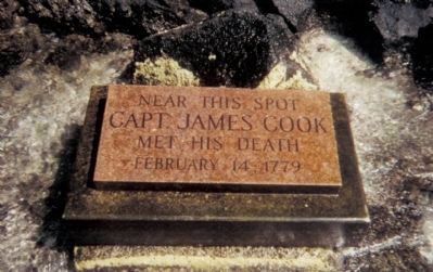
Marker panel on obelisk (1874): In Memory of the great circumnavigator
Captain James Cook, R.N. who discovered these islands on the 18th of January, 1770 and fell near this spot on the 14th of February, 1779. . . . — — Map (db m72497) HM
On Mamalahoa Highway (Hawaii Route 19) near Pauahi Street, on the right when traveling east.
(Legend to Points of Interest to on the Hilo Bay map:)
➊ Kānoe Heiau Kānoe Heiau was one of six major lauakini or sacrificial heiau on the island of Hawai'i dating back to ancient times.
➋ Naha . . . — — Map (db m111236) HM
On Mamalahoa Highway (Hawaii Route 19) near Pauahi Street, on the right when traveling east.
Kamehameha the Great was born in the 1750s and rose to become one of the most important figures in Hawaiian history. He lived during a period of great transition in Hawaiian society, having witnessed the arrival of the first Westerners when he was . . . — — Map (db m111235) HM
Near Alii Drive near Kahikina Lane, on the left when traveling north.
This sacred pond was built with lava rock and coral mortar in the mid 1800's. It once served as a bathhouse for the royal families. Fresh water empties into Ki’ ope pond through underground springs along the edges of the wall. Because of its rich . . . — — Map (db m123291) HM
On Ali'i Drive near Liana Lane, on the left when traveling north.
Niumalu Beach
Once a hub for canoeing, water gathering and some shipping, the fancy beach at Niumalu (lit. shade of the coconut tree), commonly known as Kanuha Beach, is sheltered by a sea wall that has protected beach-goers of over 100 . . . — — Map (db m110586) HM
Near Kaleiopapa Street near Ehukai Street, on the left when traveling north.
Cultural historian Henry E.P. Kekahuna was born on Maui in 1881 when many ancient Hawaiian traditions were still in practice. He listened and learned the stories of old. He explored and mapped many areas throughout Hawai'i in the 1950s. His . . . — — Map (db m110310) HM
On Kaleiopapa Street near Ehukai Street, on the right when traveling north.
In the time of the ruler 'Umi-a-Liloa, 22 generations before the time of King Kamehameha I, the Royal Center moved away from Waipi'o in the island's northern region. As a result of this move, Royal Centers developed along Kona's leeward coast, By . . . — — Map (db m110308) HM
From 1959 through 1964
Regulus was the submarine
launched retaliatory
missile in the Pacific
The Regulus missile
deterrent strike force
operated from submarine
base, Pearl Harbor, under
the operational control of
Commander Submarine . . . — — Map (db m111762) WM
Launched 24 July 1943 (shield logo) Commissioned 20 November 1943
USS Parche SS-384
These men served aboard during her six war patrols
( 191 names)
* Wolf Pack Commander
** Commanding Officer of USS Parche
*** Lost at Sea- - 10 February . . . — — Map (db m111817) WM
More than two thousand Americans were killed on December 7, 1941, almost half of them aboard USS Arizona. Military installations around the island were attacked and nineteen ships were sunk, beached, or badly damaged. Hundreds of Navy and Army . . . — — Map (db m104804) HM
He goes a great voyage that goes to the bottom of the sea, George Herbert, Jacula Prudentum, 1651
Throughout the history of submarine development, men have fought enemies just as lethal as any human foe. Those who brave the deep in . . . — — Map (db m81389) HM WM
This anchor was recovered from the Arizona
The ship had three anchors. The crew used one
in calm seas, two during foul weather, and the
third as a spare. Each weighs nearly ten tons.
Notice the size of the anchors compared to
the . . . — — Map (db m111209) WM
LCDR A.M. Bontier, USN, Commanding Officer; Launched 15 August 1939; Lost at Sea, 3 October 1944.
Beginning with her first patrol just hours after the Japanese attack on Pearl Harbor, a daring submarine embarked on a career that made the name . . . — — Map (db m81417) WM
CDR K.E. Montross, USN, Commanding Officer; Launched 1 April 1939; Lost at sea, January 1945.
Less than two weeks after the Japanese attack on Pearl Harbor, Swordfish sank her first ship. So began the career of a submarine that not only sank . . . — — Map (db m81419) HM WM
CDR R.H. Kane, USN, Commanding Officer; Launched 17 August 1943; Lost at sea, 24 October 1944.
The exploits of Tang are legendary in submarine history. Under the bold leadership of Commander Richard H. O’Kane, Tang executed five brilliant . . . — — Map (db m81473) HM WM
CDR D.W. Morton, USN Commanding Officer; Launched 14 February 1942; Lost at sea 11 October 1943.
If one submarine could be said to embody the spirit and pride of the U.S. Submarine Force, it would probably be Wahoo. Certainly the enemy . . . — — Map (db m81474) WM
On Kalahaua AVenue south of Kapiolani Boulevard, on the right.
Ala Wai (freshwater way) Canal was
at the heart of the Waikīkī Reclamation Project launched in the early 1900s “to
reclaim an unsanitary and most unsightly portion of the city.” The duck farms and the millions of mosquitoes . . . — — Map (db m13196) HM
On South King Street north of Punchbowl Street, on the right when traveling south.
King Kamehameha I (c. 1758–1819) is generally recognized as the most important figure in Hawaiian history. He was a wise ruler who enacted laws to protect the defenseless and to bring order to the newly united kingdom. An astute statesman, he . . . — — Map (db m13581) HM
On Punchbowl Street, on the left when traveling east.
In the middle of an otherwise dry and barren plane, existed a sacred spring on these grounds, reserved for use by high chiefs and chiefesses only. Legend tells us that among the high ranking who enjoyed the privilege of bathing in the large circular . . . — — Map (db m74144) HM
On Punchbowl Street, on the left when traveling east.
Born in 1824 at Mokuleia Oahu
Educated by James Hunnewell at Lahainaluna
First Hawaiian Christian Minister
Ordained at Kahuku December 21 1849
In 1853 he went as a pioneer missionary to
the Marquesas . . . — — Map (db m74147) HM
On Diamond Head Rd, on the right when traveling east.
The Hawaiian goddess Hi’iaka compared the
peak of volcanic cone of Diamond Head to the
dorsal fin of the ‘ahi fish, thus the Hawaiian name
for Diamond Head is Le’ahi.
This site was once the Dillingham Home, the
beachfront house of Harold . . . — — Map (db m111326) HM
The Navy’s Retention Excellence Award, or “Golden Anchor” is
traditionally awarded to active-service Naval vessels for meeting or
exceeding crew retention goals.
On June 11, 2005, Battleship Missouri became the first non-active . . . — — Map (db m112231) HM
U.S. Naval Base, Pearl Harbor
has been designated a
Registered National
Historic Landmark
Under the provisions of the
Historic Sites Act of August 21, 1935
this site possesses exceptional value
in commemorating and . . . — — Map (db m4526) HM
On Langley Avenue, on the right when traveling north.
At 0755, 7 December 1941,
near this spot at Berth Fox 7
The USS Arizona
was hit by one torpedo and approximately
seven bombs. One bomb went down the stack and another penetrated the black powder magazines. The sunken ship remains the tomb . . . — — Map (db m143290) HM WM
On Saratoga Boulevard north of Yorktown Boulevard, on the right when traveling east.
Near this spot, at Berth Fox 11
on the morning of 7 December 1941,
the USS Utah was struck on the portside
with what is believed to have been
three aerial torpedoes and was sunk.
She was subsequently rolled over
to clear the channel but . . . — — Map (db m60044) HM
On Saratoga Boulevard, on the right when traveling west.
This memorial was officially authorized by the 91st Congress of the United States of America on 14 October 1970. Its construction was made possible by Congressional appropriation and by the generous contributions of many individuals and . . . — — Map (db m60071) HM
On Diamond Head Rd, on the right when traveling north.
The Diamond Head Lighthouse is a prominent symbol of Hawaiian
history to residents and visitors alike.
The lighthouse rests aside a tuff-cone volcano, formed by
explosive eruptions thousands of years ago.
In 1825, British sailors ascended the . . . — — Map (db m111324) HM
Olympic swimming champion Duke Kahanamoku (1890–1986) spent much of his youth here in Kālia with his mother’s family, the Paoas. The family owned most of the 20 acres which the Hilton Hawaiian Village now occupies.
It is said that it was . . . — — Map (db m13188) HM
Near Holomoana Street south of Ala Moana Boulevard.
Fish were easily netted from the ponds near Pi‘inaio Stream.
In ancient times, the
area was home to many Hawaiian families, who enjoyed the offerings in its bountiful waters. It was not unusual to see native men and women fishing, . . . — — Map (db m13127) HM
On Kalaukaua Ave, on the left when traveling west.
Princess Lili’uokalani enjoyed spending time with Robert Louis Stevenson on Waikiki in “earnest conversation”, Feb 3, 1889
This section of Waikiki Beach contains four distinct areas: Outrigger Canoe Club, San Souci, Kapi’olani Park and Queen’s . . . — — Map (db m73122) HM
Near Kamehameha Highway (Hawaii Route 99) 0.8 miles south of Ford Island Boulevard.
The instrument of surrender terminating the Second World War was signed on this ship, 2 September 1945 east longitude date while she lay at anchor in Tokyo Bay.
The Allied representatives were • General of the Army Douglas MacArthur, The . . . — — Map (db m49677) HM
On Hawaii Route 50 at Panako Road, on the right when traveling west on State Route 50.
In January, 1778, two ships under the command of British navigator Captain James Cook sighted the northwest coast of O'ahu. The next day they cruised from Maha'ulepu to Waimea Bay on Kaua'i where they set anchor. Acquainted with the Tahitian . . . — — Map (db m65777) HM
On Honoapiilani Highwary (Route 30), on the right when traveling east.
This monument commemorates the arrival of the Norwegian barque Beta which dropped anchor near this spot on February 18, 1881, and of her sister ship Musca, which arrived in Honolulu May 13, 1881. They brought more than six hundred . . . — — Map (db m73188) HM