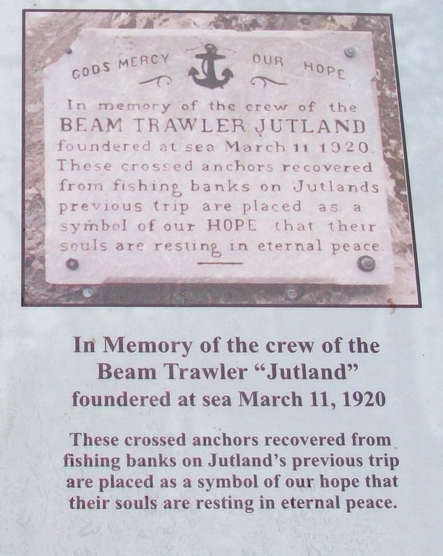
In memory of the crew of the
Beam Trawler Jutland
foundered at sea March 11, 1920
These crossed anchors recovered from
fishing banks on Jutland's previous trip
are placed as a symbol of our hope that
their souls are resting in . . . — — Map (db m112407) HM
English
The community of St. Peter’s is situated on the neck of land that separates the Bras d’Or Lake from the Atlantic Ocean. Up until the introduction of road and rail travel, the lake was the highway of the interior of Cape Breton and . . . — — Map (db m78729) HM
There are two plaques on this monument
St. Peter’s Canal / Le Canal Saint-Pierre
English
Connecting St. Peter’s Bay on the Atlantic Ocean with the Bras d’Or Lakes, St. Peter’s Canal follows substantially the portage of the . . . — — Map (db m78726) HM
English: St. Peter's native son Wallace MacAskill (1887-1956) built an international reputation for his magical marine photography, but his fascination with the sea — and the ships and people who sailed on it — went far . . . — — Map (db m151582) HM
English:
With its close proximity to abundant fishing grounds, sheltered cove and excellent fish-drying conditions, Neil's Harbour was a popular fishing base for both French and Scottish settlers in the 1700's.
Neil MacLennan, . . . — — Map (db m139870) HM
Fishing has been the backbone of Yarmouth's culture and economy for over 200 years. In the early days, salted dried cod was shipped by schooners and barques headed to the West Indies in exchange for rum, molasses and sugar. Today Yarmouth's . . . — — Map (db m107349) HM
The Southwestern shore of Nova Scotia, including Yarmouth County, is home to one of Canada's largest fisheries. For over two hundred years, fishing boats have sailed past this point, as well as from other ports in this region, to fish groundfish, . . . — — Map (db m107638) HM
An enduring symbol of Yarmouth's historic and economic ties to the sea, a lighthouse has towered over the rocky headlands of Cape Forchu since 1839, guiding mariners to the safety of Yarmouth Harbour. The current lighthouse was automated in . . . — — Map (db m107293) HM
Cheboque
The name "Cheboque" comes from the Mi'kmaw word for "big marshes", a very accurate name for this area. Beginning at Arcadia, the Cheboque salt marsh sprawls 343 hectares (837 acres) alongside the Cheboque River.
According to a 1607 . . . — — Map (db m107735) HM
Harbour of Deception
For almost two centuries, Yarmouth's False Harbour has lived up to its name. Located at the end of Cape Forchu, False Harbour's rocky shores have fooled the most experienced and capable of mariners, especially during . . . — — Map (db m107719) HM
The Town of Yarmouth, and its surrounding area, was settled in 1761 by Planters from Massachusetts. These settlers fished along the coast and harvested lumber from the forests to build homes, businesses and sailing vessels. By the . . . — — Map (db m107298) HM
The year 1879 was a disastrous one for Yarmouth County, Nova Scotia, with no fewer than 31 vessels lost along with 106 persons. The ships lost were among the best of the Yarmouth fleet, some carrying valuable cargoes. The loss of life left 26 . . . — — Map (db m107392) HM
Balise canadienne
Lorsque Samuel de Champlain visita la région en 1604, il la nomma Cap-Fourchu. Un an plus tard, Champlain s'installa à Port-Royal ou, La Cadie, un nom dérivé du nom « L'Arcadie » qu'un explorateur italien aviat donné à la . . . — — Map (db m107359) HM
Pieces of the Past
Since 1840, a lighthouse has kept watch over Cape Forchu and the approaches of Yarmouth Harbour.
In 1962, the original lighthouse was replaced with the iconic "apple core" structure that towers over the Cape today.
The . . . — — Map (db m107551) HM
Watching the waves crashing around Cape Forchu provides a small glimpse of the awesome and terrifying power of the sea. It continually shapes the lives of those who live and work by it. A source of beauty, bounty and economic prosperity, the . . . — — Map (db m107284) HM
The Tusket Islands
Located south of Yarmouth, the Tusket Islands extend mainly along the coast, from Pinkney's Point to Wedgeport. The Tusket Island chain was once a great asset to the fishing economy of Nova Scotia's Southwestern . . . — — Map (db m107652) HM
Jusaqu'aux années 1950 on pouvait encore voir plus de 1000 barges ou meules de foin entre la Pointe-du-Sault et la Pointe-des-Hubbard, surtout dans la région appelée « Passe de pré ». Des hommes habiles à la faux pouvaient faucher environ . . . — — Map (db m108766) HM
Before You Step Back in Time...
Though Le Village historique acadien is a created outdoor museum, it speaks to truths about the overall Acadian experience in Nova Scotia, and to the particular life and times of the Pubnicos in the . . . — — Map (db m108272) HM
Récolter la mer
Vous êtes debout sur l'un des quais de pêche les plus achalandés au Canada.
Autrefois, le hareng était pêché dans des parcs en fascines, ou « nijagans » inventés par les Mi'kmaq. Le poisson entrait dans le parc . . . — — Map (db m108006) HM
Following the fish
While Dennis Point's most valuable fishery is lobster, this wharf is also home to Canada's largest ground fishing fleet. This diverse fishery takes our fishermen (and women) to many special fishing areas.
Going the . . . — — Map (db m108001) HM
The year 1879 was a disastrous one for Yarmouth County, Nova Scotia, with no fewer than 31 vessels lost along with 106 persons. The ships lost were among the best of the Yarmouth fleet, some carrying valuable cargoes. The loss of life left 26 . . . — — Map (db m112154) HM
L'eau de la mer, des lacs et des rivières peut être source de bonheur, de plaisir, de richesses, mais l'eau peut être aussi source d'épreuves, de malheur.
Ce monument veut rappeler la mémoire de ceux et celles qui furent engloutis dans . . . — — Map (db m108397) HM
This Ballard [sic - Bollard]
was located on a
wharf in Yarmouth
in the early 1900's.
It's purpose was to
tie ships to the wharf.
It weighs 450 pounds.
Donated by
Mr. Danny MacIsaac — — Map (db m172552) HM
This Bell was donated to Friends of the Yarmouth Light Society by Bay Ferries.
It was located on the wharf in Yarmouth and used to help guide the ferry during times of thick fog or heavy snow. — — Map (db m172551) HM
This replica was created and donated
to the citizens of Yarmouth, Nova Scotia
from
Doug Koohtow, Holland Landing, Ontario
May 28, 2014 — — Map (db m107869) HM
Executive Director
Yarmouth Waterfront Development Corporation
It is with great pleasure that the Yarmouth Waterfront
Development Corporation dedicates this trail
to the memory of Robert E. Hartlin. The "Hartlin Trail"
extends . . . — — Map (db m107897) HM
Early transportation in Yarmouth was largely centred on the coast. Gradually, road development linked Yarmouth with the rest of Nova Scotia by land and regular passenger and mail services were established by stage coach. By 1891 railway links . . . — — Map (db m107313) HM
Dedicated to the memory of all those
residents of Yarmouth County
and crew members of ships owned
in Yarmouth County who have been
lost to the sea
We honour those here named as well
as those not yet known to us
[Remembered Dead . . . — — Map (db m107927) HM
The year 1879 was a disastrous one for Yarmouth County, Nova Scotia, with no fewer than 31 vessels lost along with 106 persons. The ships lost were among the best of the Yarmouth fleet, some carrying valuable cargoes. The loss of life left 26 . . . — — Map (db m107934) HM
This Anchor was donated to Freinds [sic - Friends] of the Yarmouth Light Society, by Bay Ferries. The fluke was broken off, when it got caught in [the] rocks on bottom, while at anchor just off the lighthouse. This anchor came off the M.V. . . . — — Map (db m172550) HM
The passage of the National Prohibition Act on January 16, 1920 signalled the prohibition of alcohol for general consumption in the United States and provided an opportunity for enterprising Yarmouth businessmen and seamen. Yarmouth-based . . . — — Map (db m106221) HM
The first vessel known to have been built in Yarmouth was launched by John Sollows at Fish Point in 1764. Over the years, many ships were built in nearby communities such as Argyle, Tusket, Plymouth, Salmon River, Meteghan, and Belliveau's . . . — — Map (db m106216) HM
From its early beginnings on Cape Breton Island the shipbuilding industry grew as settlement did in the late 18th century. During the Golden Age of Sail in the 19th century, thousands of wooden vessels of all sizes were built in bays and harbours . . . — — Map (db m106067) HM
The Age of the Passenger Steamer
With the coming of the steam engine, it was only a matter of time before the sleek lines of wooden hulls and trim masts were replaced by riveted steel plates and tall stacks. By the mid-nineteenth . . . — — Map (db m112166) HM
A cornerstone of Yarmouth's economy from its first settlement, fishing continues to the present day to be an important aspect of life in the community. Yarmouth fishermen have always pursued a diversity of species: lobsters, scallops, cod, . . . — — Map (db m106323) HM
The Killam Family Built a Business
By the third quarter of the nineteenth century, many Yarmouth companies and their owners were enjoying substantial profits as a result of their investments in shipping and labours as commission . . . — — Map (db m112200) HM
Merchants and Mariners
True to the code of merchant-mariners, Parker-Eakins & Co. saw their mission as an endeavor “to facilitate the production, distribution and exchange of goods and services for mutual profit and . . . — — Map (db m112171) HM
On this, the site of the
first launching in the county,
1764, this monument is erected
in proud memory of
all the seafaring sons
of Yarmouth County
who, "going down to the sea
in ships," by their outstanding
seamanship and . . . — — Map (db m107252) HM
138 entries matched your criteria. Entries 101 through 138 are listed above. ⊲ Previous 100