After filtering for Nova Scotia, 138 entries match your criteria. Entries 101 through 138 are listed.⊲ Previous 100
Waterways & Vessels Topic
By Unknown, Undated
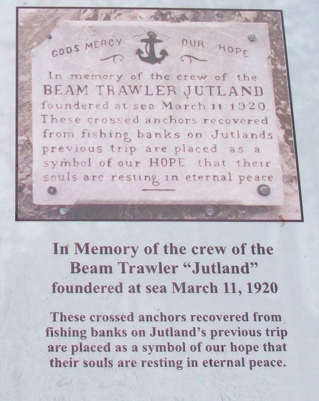
Beam Trawler Jutland Memorial Marker
| 101 ► Nova Scotia, Queens County, Liverpool — Beam Trawler Jutland Memorial |
| On Main Street (Nova Scotia Route 3) just east of Legion Street, on the right when traveling east. Reported missing. | |||
| 102 ► Nova Scotia, Richmond County, St. Peter's — St, Peter’s and Its Canal — St. Peter’s et son canal — |
| On Toulouse Street, on the right when traveling north. | |||
| 103 ► Nova Scotia, Richmond County, St. Peter's — St. Peter’s Canal / Le Canal Saint-Pierre — St. Peters / Saint-Pierre — |
| On Toulouse Street, on the left when traveling south. | |||
| 104 ► Nova Scotia, Richmond County, St. Peter's — Wallace R. MacAskill — A man of the sea, and more / Un homme de mer et encore plus — |
| On Grenville Street (Nova Scotia Route 4) west of Pepperell Street, on the right when traveling west. | |||
| 105 ► Nova Scotia, Victoria County, Neil's Harbour — Neil's Harbour — The Cabot Trail — |
| On Lighthouse Road just east of New Haven Road, on the right when traveling east. | |||
| 106 ► Nova Scotia, Yarmouth County, Cape Forchu — A Diverse Fishery — |
| 107 ► Nova Scotia, Yarmouth County, Cape Forchu — A Footstep into the Harbour — |
| 108 ► Nova Scotia, Yarmouth County, Cape Forchu — Cape Forchu's Guiding Light — |
| 109 ► Nova Scotia, Yarmouth County, Cape Forchu — Cheboque — |
| 110 ► Nova Scotia, Yarmouth County, Cape Forchu — Harbour of Deception — |
| 111 ► Nova Scotia, Yarmouth County, Cape Forchu — In Dire Need of a Lighthouse — |
| 112 ► Nova Scotia, Yarmouth County, Cape Forchu — Lost to the Sea / Perdus en Mer — |
| 113 ► Nova Scotia, Yarmouth County, Cape Forchu — Phare Cap-Forchu / Cape Forchu Lightstation — |
| 114 ► Nova Scotia, Yarmouth County, Cape Forchu — Pieces of the Past — |
| 115 ► Nova Scotia, Yarmouth County, Cape Forchu — The Power of the Sea — |
| 116 ► Nova Scotia, Yarmouth County, Cape Forchu — The Tusket Islands — |
| 117 ► Nova Scotia, Yarmouth County, Hubbard's Point — Barges de foin salé de Buttes-Amirault — Salt Haystacks of Amirault's Hill — |
| On Nova Scotia Route 308 at Chemin des Gasson, on the right when traveling south on Provincial Route 308. | |||
| 118 ► Nova Scotia, Yarmouth County, Lower West Pubnico — A Bond with the Sea / A Sustaining Faith — Un lien avec la mer / Une foi nourrissante — |
| 119 ► Nova Scotia, Yarmouth County, Lower West Pubnico — Recolter la mer / Harvesting the Sea — Quai Dennis Point / Dennis Point Wharf — |
| On Dennis Point Road, 1 kilometer south of D'Entremont Road, on the left when traveling south. | |||
| 120 ► Nova Scotia, Yarmouth County, Middle West Pubnico — Dennis Point — Living Wharves / Tchais Vivants — |
| On Dennis Point Road, 1 kilometer south of D'Entremont Road, on the left when traveling south. | |||
| 121 ► Nova Scotia, Yarmouth County, Tusket — Lost at Sea / Perdus en Mer — |
| On the Lighthouse Route (Nova Scotia Route 3), on the right when traveling north. | |||
| 122 ► Nova Scotia, Yarmouth County, West Pubnico — Perdu aux eaux / Lost to the Waters — |
| On the Lighthouse Route (Nova Scotia Route 335) at Argyle Sound Road/Martell Lane, on the left when traveling south on the Lighthouse Route. | |||
| 123 ► Nova Scotia, Yarmouth County, Yarmouth — Ballard [sic - Bollard] — |
| Near Water Street. | |||
| 124 ► Nova Scotia, Yarmouth County, Yarmouth — Bell — |
| Near Water Street. | |||
| 125 ► Nova Scotia, Yarmouth County, Yarmouth — Cape Forchu Lighthouse — |
| On Main Street, on the left when traveling north. | |||
| 126 ► Nova Scotia, Yarmouth County, Yarmouth — Hartlin Trail — Robert E. Hartlin — 1936 - 2005 — |
| On Water Street, on the right when traveling north. | |||
| 127 ► Nova Scotia, Yarmouth County, Yarmouth — Land Transportation — Connecting by Road & Rail — |
| On Water Street, 0.1 kilometers south of Richards Lane, on the right when traveling south. | |||
| 128 ► Nova Scotia, Yarmouth County, Yarmouth — Lost to the Sea — |
| On Water Street at Glebe Street, on the right when traveling north on Water Street. | |||
| 129 ► Nova Scotia, Yarmouth County, Yarmouth — Lost to the Sea / Perdus en Mer — |
| On Water Street at Glebe Street, on the right when traveling north on Water Street. | |||
| 130 ► Nova Scotia, Yarmouth County, Yarmouth — M.V. Bluenose Anchor — |
| Near Water Street. | |||
| 131 ► Nova Scotia, Yarmouth County, Yarmouth — Rum Running — Rum, Risk, and Riches! — |
| On Water Street, on the right when traveling south. | |||
| 132 ► Nova Scotia, Yarmouth County, Yarmouth — Shipbuilding — Building a Connection to the World — |
| On Water Street, on the right when traveling south. | |||
| 133 ► Nova Scotia, Yarmouth County, Yarmouth — Shipbuilding in Nova Scotia / Construction navale en Nouvelle-Écosse — |
| On Main Street at Marshall Lane, on the right when traveling south on Main Street. | |||
| 134 ► Nova Scotia, Yarmouth County, Yarmouth — the Yarmouth-Boston Ferry — |
| On Water Street at Lovitt Street, on the left when traveling north on Water Street. | |||
| 135 ► Nova Scotia, Yarmouth County, Yarmouth — The Fishery — A Community Mainstay — |
| On Water Street, on the right when traveling south. | |||
| 136 ► Nova Scotia, Yarmouth County, Yarmouth — The Killam Brothers Buildings & Wharf — |
| On Water Street just north of Central Street, on the left when traveling north. | |||
| 137 ► Nova Scotia, Yarmouth County, Yarmouth — the Parker-Eakins Buildings & Wharf — |
| On Water Street at Lovitt Street, on the left when traveling north on Water Street. | |||
| 138 ► Nova Scotia, Yarmouth County, Yarmouth Bar — Seafaring Sons of Yarmouth County — |
| On Yarmouth Bar Road (Nova Scotia Route 304), on the left when traveling south. | |||
138 entries matched your criteria. Entries 101 through 138 are listed above. ⊲ Previous 100