On Shankill Road (Northern Ireland Route B39) at Argyle Street, on the left when traveling west on Shankill Road.
In memory of five innocent Protestants
slaughtered here by a Republican murder gang
on 13th August 1975
William John Gracey aged 63
Samuel Gunning aged 55
Joanne McDowell aged 29
Hugh Alexander Harris aged 21 . . . — — Map (db m134827) HM
On Shankill Road (Northern Ireland Route B39) just east of Conway Street/Snugville Street, on the left when traveling east.
In proud memory of
a true soldier
BIG BILL CAMPBELL
Died 8th January 1997
Lest We Forget
No.5 Platoon
———————————
No. 1 Platoon 'A' Company
L.P.W.W. Scotland
1st Belfast Battalion
In Everlasting Memory Of
VOLUNTEER ALASTAIR . . . — — Map (db m135141) WM
On Falls Road (Northern Ireland Route A501) at Sevastopol Street, on the right when traveling west on Falls Road.
Ag Sráid Sevastopol cuimhhítear ar Bobby Sands i
múrmhaislú a aithnítear ar fud an domhain. Ba scríbhneoir,
file, réabhlóidi agus díograiseoir Gaeilge é Sands. Fuair sé bás
5 Bealtaine 1981 tar éis 66 lá ar stailc ocrais. As ucht . . . — — Map (db m134465) HM
On Bombay Street just east of Clonard Gardens, on the left when traveling east.
Roll of Honor
Vol. Sean Gaynor · 26th Sept. 1920
Vol. Dan Duffin · 23rd April 1921
Vol. Pat Duffin · 23rd April 1921
Vol. Seán McCartney · 8th May 1921
Vol. Gerard O'Callaghan · 31st Aug. 1942
Vol. Tom Williams · . . . — — Map (db m134620) WM
On Divis Street (Northern Ireland Route A501) 0.4 kilometers west of Westlink (Northern Ireland Route A12), on the right when traveling west.
There are many places of social and cultural significance in this vicinity. Raise your eyes and you'll see the twin spires of St Peter's Cathedral, a much-loved landmark of West Belfast. St Peter's is the mother church of the Diocese of Down & . . . — — Map (db m134447) HM
On Newtownards Road (Northern Ireland Route A20) at Hemp Street, on the left when traveling west on Newtownards Road.
[Mural]
Dedicated To
1981 Gareth Keys 2008
————————————
In Memory Of
All Our Fallen
Volunteers
We Forget Them Not
East Belfast
Ulster Volunteer . . . — — Map (db m135571) WM
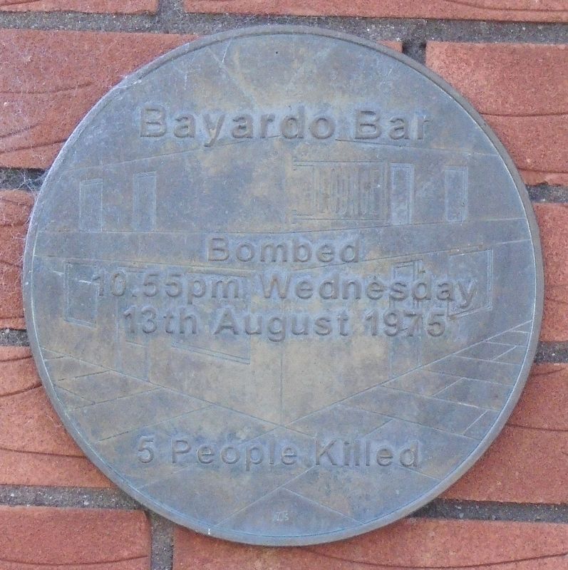
On Shankill Road (Northern Ireland Route B39) just east of Canmore Street, on the left when traveling east.
This Tablet
marks the site of Frizzel[l]’s Fish shop,
where at 1.05 p.m.
on Saturday 23rd October 1993
a terrorist bomb exploded.
9 innocent souls lost their lives
and many more were injured. . . . — — Map (db m134826) HM
On Falls Road (Northern Ireland Route A501) at Sevastopol Street, on the right when traveling west on Falls Road.
Máire Drumm
Vice President of Sinn Féin
Assassinated by Loyalists 28th Oct. 1976
We must take no steps backward,
our steps must be onward, for if we don't,
the martyrs that died for you, for me,
for this country, will . . . — — Map (db m134513) HM
On Falls Road (Northern Ireland Route A501) at Sevastopol Street, on the right when traveling west on Falls Road.
Dedicated to the memory of
Michael O'Dwyer
Sinn Féin members
Paddy Loughran and Pat McBride
who were murdered here by the R.U.C. on February 4 1992
a Mhuire Banríon na nGeal guí ar orthu
[Our Lady Queen of the Celts pray on . . . — — Map (db m134515) WM
On Falls Road (Northern Ireland Route A501) at Sevastopol Street, on the right when traveling west on Falls Road.
To the memory of
Pat (Beág) McGeown
A Soldier, politician, community worker and bridge builder
who died October 1 1996 as a direct result of
being on the 1981 Hunger Strike in the H Blocks
"To live in the hearts of those . . . — — Map (db m134512) HM WM
On Shankill Road (Northern Ireland Route B39) at Argyle Street, on the right when traveling west on Shankill Road.
Richard Mussen joined the Royal Inniskilling Fusiliers [27th Foot] at the age of 15. At the outbreak of the Zulu Wars he volunteered for active service and was transferred to the 2nd Battalion The South Wales Borderers [24th Foot]. At the outbreak . . . — — Map (db m134883) HM
On Sandy Row at Blythe Street, on the right when traveling south on Sandy Row.
In proud memory of
Robert Dougan
Murdered by the enemies of Ulster
10th. February 1998
"A gentleman till the very end
he died as he lived
He was everyones friend."
"Lest We Forget" — — Map (db m135663) WM
On Donegall Square East just south of Donegall Square North (Northern Ireland Route A1), on the right when traveling south.
In memory of the officers,
non-commissioned officers
and men of the Royal Irish
Rifles, who were killed in action
or died of wounds or disease in
the South African War 1899·1902,
this monument is dedicated. . . . — — Map (db m134293) WM
On Falls Road (Northern Ireland Route A501) at Sevastopol Street, on the right when traveling west on Falls Road.
Ball de Bhráithreachas na Poblachta,
Óglaigh na hÉireann agus Na Fianna Éireann.
Gníomhach i nGarastún Ardoifig an Phoist, Baile Átha Cliath, 1916.
Rugadh 6ú Éanair, 1890. Bhí cónaí air sa cheantar seo . . . — — Map (db m134478) HM
On Bombay Street, on the left when traveling east.
From the burning ashes of a Clonard Street is where I trace my own. Not fifty yards across the wall my blood runs blue as well. The red brick walls and darkened halls where secrets never met. For fear a neighbor lent his ear to something he'd . . . — — Map (db m134725) HM
On Bombay Street just east of Clonard Gardens, on the left when traveling east.
This plaque is dedicated to the
People of the Greater Clonard
who have resisted and still resist
the occupation of our country by Britain.
We acknowledge with pride the sacrifices
they made throughout every decade.
Their names would be . . . — — Map (db m134616) WM
On Donegall Place at Castle Street, on the right when traveling south on Donegall Place.
This plaque records the fact that on
28th. June 1701
Arthur Chichester, 3rd. Earl of Donegall
by warrant of
his late Majesty King William III
formed the 35th Regiment of Foot
which has since become famous as
The Royal Sussex . . . — — Map (db m134891) HM
On Bombay Street just east of Clonard Gardens, on the right when traveling east.
In loving memory of
Vol. Tom Williams
"C. Coy" 2nd Battalion
Belfast Brigade IRA
who lived here
and was executed in
Belfast Gaol
2nd Sept 1942 Aged 19 years
ar dheis de go rabh a anam
[To the honor of his . . . — — Map (db m134711) HM
Brian Boru was born in County Clare during
a time when Ireland was divided into kingdoms,
ruled over by one High King or "Ard Rí".
Brian Boru claimed the high kingship in 1001.
When the northern kingdoms resisted
his claim he travelled . . . — — Map (db m211031) HM
Near The Mall, 0.2 kilometers south of College Hill (National Route A3), on the left when traveling north.
This memorial is erected
by their fellow countrymen
and comrades to the memory of
the officers, non-commissioned
officers, and men of the
Princess Victoria's Royal
Irish Fusiliers who fell
in the service of their
country during the . . . — — Map (db m210222) WM
On Shipquay Place at Guildhall Square, on the right when traveling west on Shipquay Place.
City under siege
The city was twice besieged for over a hundred days. In 1649 the garrison held out against royalist troops during the English Civil War. Forty years later the city supported Protestant William III against Catholic James II . . . — — Map (db m70943) HM
Castle Balfour, built for Sir James Balfour of Glenawley by about 1620, was one of many castles designed to secure the plantation in Ulster during the 17th century. It is of the Scottish-style strong house type, identifiable by such . . . — — Map (db m71324) HM