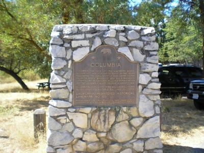
On Broadway St. at Church Street, on the left when traveling north on Broadway St..
Columbia, the “gem of the southern mines,” became a town of 4000 to 5000 in the 1850s, following the discovery of gold here by the Hildreth party March 27, 1850. Gold shipments, estimated at $87,000,000, declined rapidly after 1858 but . . . — — Map (db m81870) HM
Near Sonora Pass (California Route 108), on the left when traveling west.
"The passage of this emigrant train, which forced its way through this almost impassable section of the Sierra Nevadas in 1852, was one of peculiar hardship and suffering - excelled in this respect, perhaps only by the ill-fated one . . . — — Map (db m99562) HM
On South Washington Street south of Church Street, on the right when traveling north.
“Queen of the Southern Mines”, settled 1848 by Mexicans from Sonora, Mexico. City government established 1849. “Sonora Herald”, first newspaper in California mines, established July 4, 1950. Single copy, fifty cents; yearly, . . . — — Map (db m32021) HM
On South Washington Street at Church Street, on the right when traveling north on South Washington Street.
The Sonora Fountain was first erected in 1904 in the center of Washington Street, 75 feet northerly of its present location. Cast in an East Coast foundry, it was purchased by the Woman’s Christian Temperance Union and used for many years as a . . . — — Map (db m32018) HM
On Old Route 49 (Main Street) near Worley Street, on the left when traveling north.
Impulse turbines, also known as high pressure water wheels, were first developed in the foothill gold fields of Northern California to produce rotating mechanical power. Early water wheel designs were produced by Donnelly and Knight foundries of . . . — — Map (db m106398) HM
Near Main Street near Seca Street, on the right when traveling south.
California’s gold country was in the midst of a second gold rush when the Tuolumne County Board of Supervisors approved construction of a Jamestown Branch Jail. It was designed by Sonora architect C.W. Ayers and built by A.S. Thomas for $1060.00, . . . — — Map (db m33671) HM
On Main Street, on the right when traveling north.
(There are five markers and one dedication plaque affixed to the flagpole pedestal.)
History of Copperopolis
Copper (for ore) + opolos (for city)
Originally known as Copper Canyon, Copperopolis was established in 1860 when copper . . . — — Map (db m62356) HM
Constructed in 1827 by the Mexican government to collect custom duties from foreign shipping, a principal revenue source when Monterey was the capital of Alta California, Mexico's northernmost province. Thomas O. Larkin, US consul to Alta . . . — — Map (db m82186) HM
On Jackson Street near Gold Street, on the right when traveling west.
Here on November 29, 1858, was held the celebration in honor of the completion of the Columbia and Stanislaus River Water Company's ditch, which brought water from the north fork of the Stanislaus River to Columbia. James Wood Coffroth, attorney, . . . — — Map (db m25649) HM
The Castro/Breen adobe is associated with the early development and settlement of Mexican California. The adobe is an excellent example of blended eastern and western building methods first produced in Monterey to form the Monterey Colonial . . . — — Map (db m82243) HM
On Yaney Street west of North Green Street, on the right when traveling west.
Constructed April 1981 – August 1982
Dedicated to the Citizens of
Tuolumne County
The Board of Supervisors
Clyde D. May – Chairman
Mildred Filiberti • Sidney H. Hatler • Steven C. Szalay • Billy H. Marr • William C. Davidson . . . — — Map (db m32012) HM
On Jackson Street 0 miles Columbia Street, on the right when traveling east.
In 1856 Prosper Rocher constructed Columbia's second brewery located one-half mile east of town on the north side of Yankee Hill Road. Rocher, a French physician, was first partners with Anton Bixel in the Columbia Brewery on Italian Bar Road. . . . — — Map (db m8590) HM
On South Washington Street (State Highway 49) south of West Church Street, on the right when traveling south.
James Divoll and Joseph Bray, owners of the Bonanza mine constructed the Star Flouring Mills on this site in 1879. In August 1885 the mill burned, leaving the stone and brick walls. From the ruins they built the Opera Hall. The Hall was only active . . . — — Map (db m31926) HM
Thin black lines indicate changes in relevance. Between each pair of lines entries are ordered geographically but all have the same relevance.
* Inflectional forms of words are their plurals, singulars, and possessives as well as gramatical tenses and similar variations.