On Ohio Route 138 south of 2nd Street (U.S. 137), on the right when traveling south.
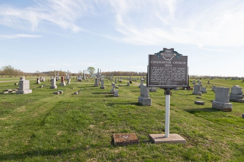
In 1804, a group of Scotch-Irish Covenanters from Rockbridge County, Virginia, erected a log church on this location. In 1805, they organized the Cherry Fork Associate Reformed Presbyterian Church. Two brick churches were also built on this . . . — — Map (db m133853) HM
On 2nd Street (U.S. 52) west of Jack Roush Way, on the right when traveling west. Reported missing.
Israel Donalson, member of the First Constitutional Convention of Ohio.
In May 1800, Congress passed an act building the Northwest
Territory, with the western division becoming Indiana
Territory and the eastern called the Territory of the . . . — — Map (db m136539) HM
Near East 8th Street, 0.2 miles east of Cemetery Street, on the right when traveling east.
Son of Nathan Ellis 1749-1819 Founder of “Ellis Ferry,” now Aberdeen, Ohio Established the Ellis Family Graveyard on his farm near Ellis’ Landing on the Ohio River Sprigg Township, Adams County, Ohio about 1820 ———— It was with thoughtful . . . — — Map (db m185498) HM
Near East 8th Street, 0.2 miles east of Cemetery Street, on the right when traveling east.
A local preacher organized a Methodist Society in 1797 at his home on the Scioto Brush Creek north of the village of Blue Creek in Adams County in the Northwest Territory. In August 1800 the Society built a log church on a site provided by Mr. . . . — — Map (db m185497) HM
On East Front Street at Pike Avenue, on the right when traveling east on East Front Street.
Manchester was founded in 1791 by Nathaniel Massie as a base to
survey the land warrants of American Revolutionary War soldiers in
the Virginia Military District. This bank of the Ohio River provided
a secure site for the last civilian stockade . . . — — Map (db m136536) HM
On West Front Street at Pearl Street, on the right when traveling west on West Front Street.
In 1784, the state of Virginia ceded all of its Northwest Territory
to the federal government except for this tract to satisfy the
land bounties owed to its Revolutionary War soldiers. The Virginia
Military District extended from the Scioto River . . . — — Map (db m136532) HM
On 2nd Street (U.S. 52) east of Cemetery Street, on the right when traveling east.
Massie’s Station, built in 1791, was the fourth
permanent settlement center in Ohio and the
last stockade settlement built in Ohio.
It
provided protection from the Indians
for
Manchester’s settlers until 1794.
Manchester was . . . — — Map (db m136537) HM
On Mineral Springs Road (County Route 18) north of Garnet Shiveley Road, on the right when traveling south.
Medicinal value of springs promoted by Charles Matheny, 1840. First hotel built 1864 and resort named Sodaville. Under ownership of General Benjamin Coates, 1888–91, Smith Grimes 1891–08, and J. W. Rogers 1908–20. Mineral Springs Health Resort . . . — — Map (db m132963) HM
Near Main Street (Ohio Route 41) at Elm Street, on the left when traveling south.
First plaque
Cairn of Peace
dedicated at
World’s Conservation Exposition
and
5th World Plowing Contest
September 19- 20, 1957
Second plaque
These competitors were in the
World Plowing Matches
Peebles, Ohio . . . — — Map (db m121814) HM
On Ohio Route 73 near Ohio Route 41, on the left when traveling east.
On the night of July 15, 1863, Brigadier General John Hunt Morgan and his Confederate raiders set up camp along a seven-mile stretch between the villages of Jacksonville and Locust Grove. The following morning, General Morgan rode into Locust . . . — — Map (db m214407) HM
On North Main Street (Ohio Route 41) near Elliott Avenue, on the right when traveling north. Reported missing.
Platted in 1881 by Isaiah Custer on the junction of old Zane's Trace (1796-97) and the Cincinnati & Eastern Railway (1881). Incorporated 1886. Named after John G. Peebles, Portsmouth, Ohio businessman. David Nixon constructed the first house in . . . — — Map (db m223788) HM
Near Ohio Route 73 west of Horner Chapel Road (Local Route 116), on the right when traveling west.
One of North America’s most spectacular effigy
mounds, Serpent Mound is
a gigantic
earthen
sculpture representative of a snake.
Built on a
spur of rock overlooking Ohio Brush Creek around
1000 A.D. by the Fort Ancient culture, the earthwork . . . — — Map (db m214413) HM
Near Horner Chapel Road (Ohio Route 73) 0.9 miles west of Horner Chapel Road (County Road T-116), on the right when traveling west.
In the traditions of many American Indian tribes, the Great Serpent was a powerful spirit. People could call upon the Great Serpent for the power to cure-illnesses or to be successful in hunting animals. The Great Serpent offered its power in the . . . — — Map (db m214415) HM
Near Horner Chapel Road (Ohio Route 73) 0.9 miles west of Horner Chapel Road (Route T-116), on the right when traveling west.
According to Tenskwatawa, often referred to as the Shawnee Prophet, when the first Shawnee people came to this land many thousands of years ago, several warriors were lost when they were taken beneath the sea on the back of an immense turtle. . . . — — Map (db m214417) HM
Near Horner Chapel Road (Ohio Route 73) 0.9 miles west of Horner Chapel Road (County Road T-116), on the right when traveling west.
Frederic W. Putnam, the Harvard University archaeologist who studied Serpent Mound in the late 1800s, described this area as a village site - actually two overlapping village sites, one earlier and one later.
Here he found "sites of . . . — — Map (db m214418) HM
On Horner Chapel Road (Ohio Route 73) 0.9 miles west of Horner Chapel Road (County Road T-116), on the right when traveling west.
An effigy mound is a geoglyph, or symbol made of earth. The most common effigy mounds in North America are animal effigies.
Ohio has only two well-documented effigy mounds, Serpent Mound and Alligator Mound.
Ohio's effigy mounds were . . . — — Map (db m214420) HM
On Ohio Route 41 at Adkins Rd, on the right when traveling north on State Route 41.
The inn was built 1800-01 by Peter Wickerham,
a Revolutionary War veteran. It was used as
an overnight stagecoach stop and tavern on
Zane's Trace until ca. 1850. Runaway slaves were
hidden here when the "Underground Railroad" was
in operation. . . . — — Map (db m108129) HM
On Ohio Route 73, 0.9 miles west of Horner Chapel Road (County Road T-116), on the right when traveling west.
The head of Serpent Mound is lined up to the point on the western horizon where the sun sets on the Summer Solstice – the longest day of the year.
Some think the three main curves of the serpent's body point to the Summer Solstice sunrise, . . . — — Map (db m214409) HM
On Ohio Route 73, 1 mile west of Horner Chapel Road (County Road T-116), on the right when traveling west.
"the most singular sensation of awe and admiration overwhelmed me … there seemed to come to me a picture as of a distant time, of a people with strange customs, and with it came the demand for an interpretation of this mystery. The . . . — — Map (db m214412) HM
On Ohio Route 73, 0.9 miles west of Horner Chapel Road (County Road T-116), on the right when traveling west.
Serpent Mound sits within a large crater almost nine miles across. The bedrock in the center of the crater has been thrust upwards to between 400 and 900 feet above its original position, while an outer ring of bedrock has dropped from at least . . . — — Map (db m214414) HM
On Ohio River Scenic Byway (U.S. 52) 0.3 miles west of Blue Creek Road (County Highway 18), on the right when traveling west.
A thriving riverport in the 19th Century founded in 1835 by William Stout. Elisha Stout, son of William, born and raised here, was one of the founding fathers of Omaha, Nebraska and Denver, Colorado. Former site of Adamsville which served as the . . . — — Map (db m73138) HM
On Main Street (Ohio Route 247) south of Tri County Road, on the right when traveling south.
Founded 1887 by John Q. Roads on the Cincinnati & Eastern Railway (1881) and the Old West Union Road (1807). Incorporated 1911. Named after Franklin Seaman who donated land to the railroad for a station. Home of Will Rogers, "The Black King of the . . . — — Map (db m108200) HM
Near Ohio Route 73, 0.9 miles west of Horner Chapel Road (County Road T-116), on the right when traveling west.
"Serpent Mound was purposefully built for a special, sacred purpose. I should think that anyone that views the Serpent will realize its sacredness and treat this place as they would any cathedral, synagogue, or mosque. When we see . . . — — Map (db m214419) HM
On Ohio Route 73, 0.9 miles west of Horner Chapel Road (County Road T-116), on the right when traveling west.
The ancestors of the American
Indians of the Eastern Woodlands
built Serpent Mound, but archaeologists
disagree about when they built it.
Some
argue
that the Adena culture
built the mound around 2,300 years
ago. This is the same culture . . . — — Map (db m214422) HM
On Ohio Route 73, 0.9 miles west of Homer Chapel Road (County Road T-116), on the right when traveling west.
Archaeologists from Ohio Valley Archaeology, Inc. assisted by volunteers, followed up on the magnetometry survey by excavating a trench across a portion of the lost coll feature. The results suggested that part of the mound had once covered this . . . — — Map (db m214408) HM
Near Ohio Route 73, 0.9 miles west of Homer Chapel Road (County Road T-116), on the right when traveling west.
The serpent head was first described by Squire and Davis in "Ancient Monuments of the Mississippi Valley" 1843
Saved from destruction in 1885 by Fredrick Ward Futnam, Professor of American Archaeology and Ethnology, Harvard University. . . . — — Map (db m214416) HM
On North Chery Street west of North Cross Street (Ohio Route 247), on the right when traveling west.
This structure erected 1835 as Associate Reformed Presbyterian Church. Congregation organized in 1812. Many members active participants in Underground Railroad. Church closed 1894. Oscar C. Roebuck operated mortuary here 1909 ’till 1936. Then used . . . — — Map (db m135304) HM
On West Main Street (Ohio Route 41) at North Cherry Street, on the right when traveling west on West Main Street.
The Bradford Tavern, West Union’s first inn built circa 1804,
served the Maysville-Zanesville stagecoach route and such travelers as Andrew
Jackson, Henry Clay, and Santa Anna. After 1840,
it was continued as the Marlatt House and,
later, the . . . — — Map (db m135307) HM
On North Cross Street at West Main Street, on the right when traveling north on North Cross Street.
Country music writer and recording star
Lloyd Estel Copas was born on July 15,
1913 on Moon Hollow near Blue Creek in
Adams County, Ohio. Reared by musical
parents, he learned to play the guitar
and fiddle at an early age and began
a singing . . . — — Map (db m135306) HM
On Second Street (Ohio Route 247) at East Walnut, on the left when traveling south on Second Street.
side A
First Presbyterian Church
The First Presbyterian Church of West Union, built in 1810, is known as the "Church of the Governors." Although the date is uncertain, the congregation was organized circa 1800 on Thomas Kirker's land on . . . — — Map (db m122227) HM
On North Wilson Drive at Mulberry Street, on the right when traveling north on North Wilson Drive.
Hon. John T. Wilson's tribute to the Soldiers.
1861 - 1865.
Ohio Bicentennial
1803-2003
Rededicated June 14, 2003
In celebration of the Ohio Bicentennial
In memory of the Soldiers of Adams County Ohio who were killed or died . . . — — Map (db m199326) WM
Near South Cherry Street south of West South Street, on the right when traveling south.
The William Lafferty Memorial Funeral and Carriage Collection shows the development of the
funeral business since the mid-1800s through an
exhibit of caskets, funeral clothing, and hearses
collected and preserved by James William . . . — — Map (db m135347) HM
On West South Street at South West Street, on the left when traveling west on West South Street.
A short distance south of Zane’s Trace, West
Union was established by an act of the Ohio
Legislature on April 13, 1803, as the seat of
Adams County. West Union was surveyed in the
spring of the following year, and became
important stagecoach . . . — — Map (db m135312) HM
On North Cherry Street west of North Cross Street (Ohio Route 247), on the right when traveling west.
Members of the Associate Reformed Presbyterian
Church settled in Adams County as early as 1797.
The West Union congregation was organized in 1812,
and a lot was purchased for the construction of a
public house of worship. This brick church, . . . — — Map (db m135303) HM
On Zane Trace (Ohio Route 41), on the right when traveling south.
Ohio’s first highway and mail route authorized by Congress 1796 marked and cleared in 1797 by Col. Ebenezer Zane a blazed trail, it became the route of the old stage line from Maysville to Wheeling used by noted statesmen to and from the . . . — — Map (db m121836) HM
On Ohio Route 41 at Texas Street, on the right when traveling north on State Route 41.
Originally a vigilante group, the Anti-Horse Thief Society was formed here in March 1853 by area landowners to recover stolen horses and prosecute the thieves. Horse theft was a serious offense in the antebellum era. Trustees nominated a captain and . . . — — Map (db m214406) HM
On East Washington Street at Main Street (Ohio Route 136), on the right when traveling west on East Washington Street.
Confederate Brigadier General John Hunt Morgan
and his raiders galloped into Winchester about 8:30 am
on July 15, 1863. The rebels immediately began searching
businesses and private residences for firearms, food, horses
and anything else that . . . — — Map (db m108236) HM
On Main Street (Ohio Route 136) at Dorsey Road (Local Route 48) on Main Street.
Winchester, Ohio. Founded November 8, 1815 by General Joseph
Darlinton and named for his Virginia birthplace.
Winchester was incorporated in 1864 and later
became the eastern terminus of the Cincinnati and
Eastern Railway (1877-1880). The . . . — — Map (db m133890) HM
On Ohio River Scenic Byway (U.S. 52) 1.5 miles west of State Highway 247, on the right when traveling west.
One half mile north of this monument the home of Gen. Nathaniel Massie, founder of Manchester in 1791, first settlement in the Virginia Military District. Residence of Charles Willing Byrd, Secretary and Acting Governor, Northwest Territory and . . . — — Map (db m45344) HM
On West Street/Napoleon Road at Lincoln Highway (Ohio Route 696), on the left when traveling north on West Street/Napoleon Road.
Dedicated to those from Beaverdam
& vicinity who served their country in the
war for the liberty of the world
1941 - 1945
To honor all men and women
of this community who nobly served
their country in World War II
and in memory of . . . — — Map (db m29927) WM
On West Main Street (Ohio Route 696) just west of Mill Street, on the left when traveling west.
This memorial is dedicated to all the men an women
who served our country in times of war and peace
so that we might have the freedoms we all love.
Our flag does not fly because the wind moves it.
…It flies with the last breath of each . . . — — Map (db m196214) WM
On North Pevee Road, on the right when traveling north.
Upon this hallowed ground. Pleasant Hill Methodist Church stood for nearly a century (1887 - 1982) serving well the surrounding community of farm families, many of whose members lie at rest in the adjacent cemetery. — — Map (db m238508) HM
On North Main Street north of Vine Street, on the left when traveling north.
First National Bank - 1892-1918
Day Barber Shop - 100+ years
Bluffton Post Office - 1904
Hamp Swank Restaurant - circa 1919
Carter Notion Store 5¢ to 10¢ - circa 1922
Moser-Bixel Ford Floor Mats - circa 1925
Kroger Store - circa 1925 . . . — — Map (db m196221) HM
On East Elm Street east of North Main Street, on the left when traveling east.
Bluffton, Ohio Est. 1861
Celebrating Our Heritage
This fair lady continues to bless our modern & diverse community.
Early explorers & surveyors paved the way for Mennonite homesteads.
Native peoples enjoying Nature's . . . — — Map (db m196224) HM
On East Jefferson Street (Ohio Route 103) west of Huber Street, on the right when traveling east.
Dedicated to Jim, John & Fred Herrmann and all Bluffton Veterans of World War II
World War II Veterans that lived in Bluffton, Beaverdam and Richland Township when they served their Country.
Agin, Ivan • Althaus, Cleon • Althaus, . . . — — Map (db m239486) WM
On Lincoln Highway (U.S. 30) at George Street, on the right when traveling west on Lincoln Highway.
Memorial Park hosted the famous Kansas City Monarchs during a barnstorming tour on August 4, 1961. The home team was the Lima Metro League’s Cairo Merchants. Legendary pitcher Leroy “Satchel” Paige (1906-1982) appeared on the mound for the Monarchs. . . . — — Map (db m230339) HM
On South Conant Road, on the right when traveling south.
WWII 78,000+ Korea 8,000+ Vietnam 1,700+ Cold War 100+ Desert Storm-Iraq ? Thanks for Remembering the ones who haven't returned home When one American is not worth the effort to be found, we as Americans have lost. — — Map (db m235861) WM
On Lincoln Highway (Ohio Route 66) just west of North Main Street (Ohio Route 66), on the left when traveling east.
Delphos
Delphos began and flourished as separate settlements: East Bredeick, West Bredeick, Howard, and Section
Ten (named after a section of the canal). In 1851, Father John Otto Bredeick, a Bavarian priest who had purchased and founded this . . . — — Map (db m159752) HM
On Lincoln Highway (Ohio Route 66) at North Main Street, on the right when traveling east on Lincoln Highway.
(Side 1)
Erected by
Reul Post No. 95 G.A.R.
And our patriotic people
1898
(Side 2)
Liberty and equal rights for all
Now and forever
(Side 3)
Dedicated to
Our country's defenders
and
Preservers
The . . . — — Map (db m166762) WM
On Lincoln Highway (Ohio Route 66) at North Main Street (Ohio Route 66), on the right when traveling east on Lincoln Highway.
Hilary Allemeier •
Leonard Finlay •
Donald J. Pohlman •
Harry Ricker •
Charles E. Stocklin
"They will live in our hearts forever"
Hills of Snow
Fifty thousand were laid low
since we fought for hills of snow
did our best . . . — — Map (db m166748) WM
On Lincoln Highway (Ohio Route 66) at North Main Street (Ohio Route 66), on the right when traveling east on Lincoln Highway.
The Purple Heart
A greater measure of service
Awarded to those wounded or killed in service to their country for military merit. — — Map (db m166764) WM
On Lincoln Highway (Ohio Route 66) at North Main Street (Ohio Route 66), on the right when traveling east on Lincoln Highway.
…remember those who served, those who fought…
those still missing, and those who gave their last full
measure of devotion for our country.
-President Ronald Reagan — — Map (db m166769) WM
On Lincoln Highway (Ohio Route 66) at North Main Street (Ohio Route 66), on the right when traveling east on Lincoln Highway.
David Bracker •
Robert King •
John Merschman •
Curtis Stocklin
"They answered the call"
It has always been the soldier
It is the soldier,
not the president who gives us democracy.
It is the soldier,
not the . . . — — Map (db m166750) WM
On Lincoln Highway (Ohio Route 66) at North Main Street (Ohio Route 66), on the right when traveling east on Lincoln Highway.
Thomas Callahan •
George H. Hemme •
Raymond V. Patton •
Edwin C. Smith •
George J. Nolte •
Clifford Lambert •
Glenn Truesdale •
Claude L. Walterick •
Herman Weaver •
William A. Sheeter •
Ferrell R. Swink
"Their valor shall . . . — — Map (db m166760) WM
On Lincoln Highway (Ohio Route 66) at North Main Street (Ohio Route 66), on the right when traveling east on Lincoln Highway.
Our fallen heroes
Gone but not forgotten
Evan H Jones Jr •
Jesse Black •
Thomas Bohnlein •
Richard Bryan •
Edward Burger •
Norman Clawson •
David Ditto •
Clement Falter •
Chaplain •
Harold Flanagan •
Walter French • . . . — — Map (db m166746) WM
On North Washington Street just north of East 2nd Street, on the right when traveling north.
Built prior to the Civil War, circa 1850's. The oldest brick house in Delphos, displaying Federal and Greek Revival style influences. Moved to the present site on July 10, 2000 by Historic Landmarks of Delphos. — — Map (db m184338) HM
On North Main Street (Ohio Route 66) just north of East 2nd Street, on the right when traveling north.
On this site once stood the original St. John the Evangelist Catholic Church
Built in 1844, the one and one-half story 18'×24' log structure served as a church, as a home for the founding pastor, the Rev. John Otto Bredeick, and as a school. . . . — — Map (db m184335) HM
Near West Main Street west of South Greenlawn Avenue, on the left when traveling west.
Sacred to the memory of
Abraham Doner
1795-1854
Founder of several Lutheran Congregations in Allen County, Ohio Buried with other Lutheran Pioneers on this site — — Map (db m196321) HM
On Allentown Road (Ohio Route 81) west of Poling Road, on the right when traveling west.
Settled by veterans
War 1812
Founded by
William Myers
and
George Povenmire
March 15 1834
Early settlers
of
Allentown Ohio
1828 - 1900
John Enslen •
George Myers •
Smith Cremean •
Charles G. Wright . . . — — Map (db m208370) WM
On North Wapakoneta Road, 0.4 miles south of Allentown Road (Ohio Route 81), on the left when traveling north.
To all Hermon, Rager, Freund and Plescher family members who have served in the U.S. military: We are very grateful for your contributions to our country. — — Map (db m196313) WM
On East Main Street at Roger Street, on the right when traveling east on East Main Street.
Elida, Ohio Village Solicitor
January, 1974 - December, 2008
Memorial
Husband, Father, Friend
World War II and Korean War veteran
Lawyer - Civic Leader - Church Leader
A quiet, soft spoken gentle man
ready to help make your life . . . — — Map (db m196320) HM
On Buckeye Road, 2 miles east of Ft. Amanda Road, on the left when traveling east.
Originally built in 1983, this M1E1 Abrams Main Battle Tank was one of 14
prototypes used as engineering test vehicles.
This M1 was returned to the Lima Army Tank Plant in late 1993 for refurbishment
and permanent display. A team of U.S. . . . — — Map (db m196375) HM
This original alloy steel school bell rang for the children attending the Sharp School located on Delong Road. The Sharp School was built in 1870 and was one of eleven one-room school houses in Shawnee Township by 1874. In 1926, ten of the schools . . . — — Map (db m196047) HM
On Spencerville Road (Ohio Route 117), on the left when traveling west.
Shawnee Indian Reservation
1817-1831
Established by treaty with the Shawnee Indians September 29, 1817, following the War of 1812.
This 25 square mile reservation which adjoined the United States military reserve, was occupied by the . . . — — Map (db m196048) HM
On Buckeye Road east of Ft. Amanda Road, on the right when traveling east.
The many boulders you see represent the conflicts and
wars in which the United States of America has been
involved since
1776. Those conflicts and wars
are identified on
the gray plates at
the bottom of
each flag column. — — Map (db m196377) WM
On Buckeye Road east of Ft. Amanda Road, on the right when traveling east.
The monument is made of five pillars,
each twenty feet tall, bearing
porcelain tile or “brick plates". Each
red, white, or blue brick has the name
of a veteran, current service person, or
citizens who simply want to say,
"Thank You” to our . . . — — Map (db m196378) WM
On Buckeye Road east of Ft. Amanda Road, on the right when traveling east.
The concept of the Freedom flag Monument began in
2001 as a way to thank U.S. Veterans for their service.
Initiated and guided by the UAW from a small cardboard
model, plans were developed and ground was broken in
2004. The monument was . . . — — Map (db m196379) WM
On Buckeye Road east of Ft. Amanda Road, on the right when traveling east.
The Freedom Flag Monument stands in honor of all U.S. Veterans - past, present, and future. In addition to the five major branches of service, veterans of these services are also recognized:
Air National Guard •
U.S. Air Force Reserve • . . . — — Map (db m196380) WM
9280 entries matched your criteria. The first 100 are listed above. Next 100 ⊳