Near Derryhubbert Road, 0.5 kilometers Derrylileagh Road.
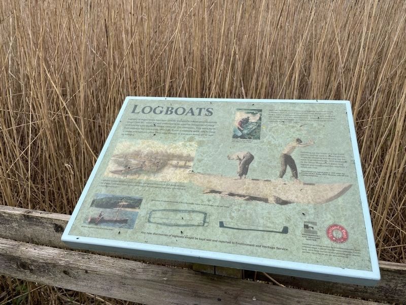
Logboats or dugout boats have been used for transport in Ireland since Mesolithic times (7000 BC - 4000 BC) and continued to be used for thousands of years well into the Late Medieval Period 16th and 17th centuries). They were made from hallowed . . . — — Map (db m196977) HM
On Donegall Square East just south of Donegall Square North (Northern Ireland Route A1), on the right when traveling south.
Erected to the imperishable memory
of those gallant Belfast men whose
names are here inscribed and who
lost their lives on the 15th April, 1912,
by the foundering of the Belfast built
R.M.S. Titanic, through collision . . . — — Map (db m134331) HM
This plan shows the extent of Harland and Wolff's shipyard on Queen's Island in 1908. The Queen's Island shipyards were highly successful at this time; 247 ships were built on the island between 1900 and 1913, more than any other shipyard in the . . . — — Map (db m135267) HM
On Divis Street (Northern Ireland Route A501) at Northumberland Street, on the right when traveling west on Divis Street.
Abhainn na Feirste
Cé go bhfuil sí clúdaithe faoi choincréit anois agus gan a
bheith le feiceáil, is ag an láthair seo ar Shráid
Northumberland a chéadtrasnaíonn Abhainn na Feirste
Bóthar na bhFál. Ainmníodh an abhainn as an . . . — — Map (db m134462) HM
Hamilton Graving Dock was continuously in use with ships being repaired, serviced or fitted out. It was leased by the Harbour Commissioners to Belfast's two main shipyards, Harland and Wolff and Workman Clark, as well as to ship owners. . . . — — Map (db m135388) HM
[Front]
Building the Dock 1864-1867
The construction of the dock began in February 1864 and was finished within three years. Four hundred and fifty men were employed to build the graving dock and the adjoining basin.
The . . . — — Map (db m135286) HM
[Front]
Building the Dock 1864-1867
The construction of Hamilton Dock began in February 1864 and was finished within three years.
[Top blue inset caption reads]
This is the office of the Deputy Harbour Master, whose . . . — — Map (db m135341) HM
Constructed in 1867, the caisson is one of the oldest surviving vessels built by Harland and Wolff.
The caisson is a hollow gate which closed off the entrance to the dock. Shaped like a ship's hull, it is made of wrought iron and hollow . . . — — Map (db m135264) HM
Select, turn, listen...
Find out more about how Hamilton Graving
Dock worked. Select a channel and turn the
handle a few times to play each audio track.
1 Keel blocks
2 Caisson
3 Diver
Time spent by ships in the dock . . . — — Map (db m135275) HM
[Excerpts with historical information]
Belfast Harbour Commissioners' Offices
The magnificent office building of the Harbour Commissioners, who were responsible for the construction of Hamilton Dock in the 1860s, was first opened in 1854, . . . — — Map (db m135369) HM
On Queens Road just north of Bell's Theorem Crescent, on the left when traveling north.
This long three storey office building in sandstone and brick was the headquarters for Harland and Wolff. When this company was at its peak in the early to middle years of the 19th [sic - 20th] century, it was one of the mightiest shipbuilding . . . — — Map (db m135514) HM
Hamilton Graving Dock opened in 1867. It was almost twice the size of No. 2 Graving Dock which had been completed in 1826.
3 million gals
The dock holds approximately 3 million gallons of water, the same volume as five and half swimming . . . — — Map (db m135405) HM
To ensure good quality work,
the commissioners hired a mason
specialising in dock construction,
who was paid £2 5s 0d per week.
This was over four times the amount
a worker in a country mill earned.
—————————————— . . . — — Map (db m135284) HM
Only the very best quality stone
was used for dock construction.
The Belfast Harbor Commissioners visited
the site regularly to inspect progress.
——————————————
Irregular stonework was used to
strengthen the dock walls. . . . — — Map (db m135285) HM
Hamilton Dock was refurbished in 1948, when a new 25-inch (64cm) concrete floor was laid. It remained in use until the 1990s, but then fell into decline.
In 2009, work began to restore the dock, now a NIEA Scheduled Monument and the oldest . . . — — Map (db m135402) HM
On Queens Road at Bell's Theorem Crescent, on the left when traveling north on Queens Road.
Hamilton Graving Dock
The 450th long Hamilton Graving Dock (1863 - 1867) was the first graving dock to be built on the County Down side of the River Lagan. It is serviced by the 12 acres of sheltered water that form the Abercorn . . . — — Map (db m135446) HM
On Queens Road just north of Bell's Theorem Crescent, on the left when traveling north.
The names Edward Harland and Gustav Wolff are inextricably linked with Belfast's shipbuilding industry. Their partnership laid the foundations for what was to become one of the greatest shipyards in the world. To this day, Harland and Wolff's two . . . — — Map (db m135509) HM
These blocks originally sat at the bottom of Hamilton Dock.
They were used to support ships' hulls.
You can see similar blocks under Nomadic's keel. — — Map (db m135404) HM
On Great Victoria Street (Northern Ireland Route A1) just north of Wellwood Street, on the left when traveling north.
Submariner
Born in Belfast
———————————
Acting Leading Seaman
James Joseph Magennis
VC, Royal Navy
Was born in Belfast
Awarded the VC for his action on 31 July . . . — — Map (db m135308) HM WM
On Newtownards Road (Northern Ireland Route A20) at Albertbridge Road (Northern Ireland Route A20), on the left when traveling west on Newtownards Road.
From the mid 1800s, the Connswater was the driving force behind east Belfast's industrial growth. Barges laden with raw materials and goods travelled its length and its waters powered many cotton and flax mills, such as the Portview . . . — — Map (db m135564) HM
Turn and listen…
Find out about the dockside scene.
Just a few turns of the handle will
play the track.
Hamilton Dock
It's 1911 - Nomadic is being floated out
of Hamilton Dock following her fit our.
1 Titanic in Arrol . . . — — Map (db m135272) HM
[Front]
The Olympic Slipway is where RMS Olympic was built beside her sister ship, Titanic. Although quiet and peaceful today, in 1910 this entire area was a hive of human industry, reverberating to the deafening din from steel plates being . . . — — Map (db m134902) HM
Built on Queen's Island as a tender ship for the White Star Line, SS Nomadic is most famous for the part she played in the Titanic story.
Based in Cherbourg, France, Nomadic transferred passengers from the quayside to enormous passenger liners . . . — — Map (db m135268) HM
'Our harbour now stands among the finest in the United Kingdom.'
Belfast News Letter, 2 October 1867
Hamilton Dock was filled at high tide and emptied at low tide.
[Photo caption reads]
Above This cross-section . . . — — Map (db m135269) HM
[Front]
Queen's Island
From Pleasure Garden to Shipyard
Edward Harland and Gustav Wolff's shipyard, which would go on to become the most successful in the world, was established in 1861.
[Blue inset caption reads]
The . . . — — Map (db m135321) HM
[Front]
Queen's Island
From Pleasure Garden to Shipyard
Queen's Island was created in 1847 when slobs from the digging of Victoria Channel were deposited on the Co. Down side of the Lagan Estuary.
Queen's Island was . . . — — Map (db m135338) HM
This plaque was unveiled
on 31st March 2009
by
John M Andrews,
great nephew of
Thomas Andrews, Chief Naval
Architect, Harland & Wolff
to commemorate the
centenary of
the keel laying of
RMS Titanic
Built on this slipway . . . — — Map (db m134932) HM
'Belfaste is a place meet for a corporate town, armed with all commodities, as a principal haven, wood and good ground, standing also upon a border, and a place of great importance for service ...'
Extract from a letter to the Privy . . . — — Map (db m134933) HM
1922 The Shipyards Expand Eastwards
The First World War had been a period of frantic activity in the shipyards of Belfast, with orders for both new warships and running repairs to the fleet. In 1917, both Harland & Wolff and Workman Clark & . . . — — Map (db m135114) HM
On Donegall Square North (Northern Ireland Route A1) at Donegall Square West, on the right when traveling east on Donegall Square North.
Mayor of Belfast 1892 and 1893.
Lord Mayor 1901, 1902, 1903, 1905 and 1906.
Freeman of the City.
M.P. for Belfast-North-.
Obit 1907.
Erected by his many friends
in appreciation of the numerous
public services rendered
by him to the . . . — — Map (db m133963) HM
The deck to the front, or fore, of a ship is called the forecastle deck. The term - pronounced 'fok-sel' - is an ancient one that originally referred to defences that were found on a warship.
Only the crew were allowed on the forecastle. . . . — — Map (db m135386) HM
The dock was a hive of activity with up to two ships being worked on by large teams of men from the shipyards. The workers stood on wooden platforms called stages.
Brand new ships were also 'fitted-out' in the dock, with their final . . . — — Map (db m135397) HM
From the quayside, third-class passengers boarded Nomadic through gates on either side of the poop deck, separated from the first and second-class passengers. Then they descended the stairway to enter the third-class deck.
The hatch leads . . . — — Map (db m135346) HM
The pump house, built c.1867, contained the important machinery used to empty the dock of water. Inside the pump house was a boiler and a steam engine, which drove one underground centrifugal pump. A tall brick chimney - to release fumes and . . . — — Map (db m135437) HM
In the mid-1920s, the original steam-powered pumps were replaced by ones driven by electric motors.
Each of the 125 horsepower electric motors, which can still be seen inside, drives a pump in the underground well. Above the motors you can . . . — — Map (db m135438) HM
On Donegall Quay (Northern Ireland Route A2) at Queen's Square, on the left when traveling south on Donegall Quay.
Welcome to the Quays at the mouth of the River Lagan. Set around the Lagan Weir the Quays incorporate Queen's Quay, Hanover Quay, Gregg's Quay and Donegall Quay, all closely linked with the origins of Belfast. The city derives its name from the . . . — — Map (db m135226) HM
KEY
(1) (2) The illuminated blue lines demonstrate the actual size and location of the Titanic (1) and Olympic (2) ships constructed on these two Slipways.
(3) The turfed and decked areas denote the proportions of people that survived . . . — — Map (db m135002) HM
On Donegall Square East just south of Donegall Square North (Northern Ireland Route A1), on the right when traveling south.
Titanic Memorial Garden is a permanent tribute to over 1,500 passengers and crew who died after the ship struck an iceberg and sank in the North Atlantic during its maiden voyage in April 1912.
When RMS Titanic departed Southampton on 10 . . . — — Map (db m134337) HM
[Front]
On 31 May 1911, SS 401, Titanic, slid down Slipway No. 3 at the Queen's Yard of Harland and Wolff and settled on the waters of the Victoria Channel in Belfast Lough. In her brief life she would be the largest, most luxurious vessel ever . . . — — Map (db m135088) HM
On Donegall Square East just south of Donegall Square North (Northern Ireland Route A1), on the right when traveling south.
In loving and most grateful memory of
my beloved husband
William James Pirrie
1st Viscount K.P. P.C. H M.L.
Born 31st May 1847 - Died 7th June 1924.
Only son of
James Alexander Pirrie and . . . — — Map (db m134345) HM
On Union Hall Place, on the left when traveling north.
Near this spot was landed the body of
Michael Browning
Master of the ship
Mountjoy
of Londonderry - killed in action at the breaking of the boom, July 28th 1689.o.s. while leading the van of the relieving squadron against the . . . — — Map (db m70925) HM
'A city fit for war and merchandise'
In 1600 Elizabeth I of England instructed Sir Henry Docwra to establish and fortify a new settlement on the Foyle. An explosion in the cathedral in 1567 had largely destroyed the town. Docwra and his . . . — — Map (db m71123) HM
On Main Street (A47) at the entrance to the Belleek Pottery Factory, on the left when traveling north on Main Street (A47).
During the Second World War (1939-1945) Sunderland and Catalina Flying Boats from RAF Castle Archdale were given permission by the neutral Irish Free State government to fly along the River Erne between Belleek and Ballyshannon. This was known . . . — — Map (db m72536) HM WM