About Castle Fraser
In the early 1600s, Andrew Fraser of Muchall transformed the home of his ancestors into a magnificent symbol of wealth, status and European culture. Castle Fraser's great entrance court, soaring towers and heraldic carvings . . . — — Map (db m128340) HM
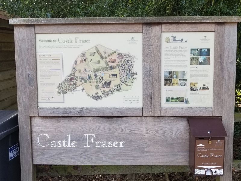
Welcome to Castle Fraser Walled Garden
Castle Fraser's gardens were originally much closer to the castle, as was typical in 17th century Scotland. In 1794, the lady laird, Miss Elyza Fraser commissioned Thomas White to draw up a plan to . . . — — Map (db m128341) HM
Fedderate Castle
From A.D. 1370 to 1573 the home of the Craufurds of Fedderate, ancestors of the Swedish Family of Crafoord
A castle seems to have been on this site since AD 1200. The ruins are from a castle built ab. 1475. It was described as a . . . — — Map (db m122811) HM
Cala air Falach
A Hidden Haven
The castle and its peninsula still shelter Dunstaffnage Bay from the worst of the westerly winds. They also hid moored vessels from the view of potential attackers.
Tides of Fortune
For several . . . — — Map (db m127407) HM
Sealladh Àrd
A Towering Outlook
The superb strategic location of the castle within a network of coastal strongholds, gave it panoramic views in all directions. No vessel — or marching army — could approach Dunstaffnage without . . . — — Map (db m127411) HM
Air cùl Bhallachan
Behind the Walls
You can see how these high walls and the single entrance made the castle safe. Its life as a private residence lasted until 1888, when most of its buildings were in ruins.
Changing Times, Changing . . . — — Map (db m127409) HM
Cridhe a’ Chasteil
Core of the Castle
This courtyard was the heart of a busy, well-defended community. At one time, there was a drawbridge to stop uninvited visitors from getting in.
A Safe Shelter
The castle in the early . . . — — Map (db m127406) HM
Fàilte do Chaisteal Dhùn Staidhinis
Welcome to Dunstaffnage Castle
Duncan MacDougall built this fortress as a statement of his status as Lord of Lorn. It is one of Scotland's oldest stone castles and guards the approaches to Loch Etive. . . . — — Map (db m127402) HM
Ceartas is Cuirmean
Justice and Joviality
The great hall occupied the whole floor above you. It was the hub of the castle, where the Lord of Lorn sat in banquets in the evening.
Gone is the Grandeur
The great hall was part of . . . — — Map (db m127405) HM
Air Faire
Watching, Waiting and Warning
Soldiers on the wall walk scanned sea and land for enemy attacks and alerted their officers in the guard room above you.
Firing Through Fishtails
When the castle was built, arrow slits . . . — — Map (db m127412) HM
Dog
Cemetery
The Small Garden Below
Has Been Used Since
Queen Victoria's Reign
(1837-1901) As A Burial
Place For Regimental
Mascots And Officers' Dogs — — Map (db m126932) HM
Foog's
Gate
The Main Entrance To The
Citadel By The 17th Century.
The Perimeter Wall. Looped
For Both Cannon And
Musketry, Was Built In
King Charles Ii's Reign
(1660-85) — — Map (db m126885) HM
Gatehouse
1887
Built As An Impressive
Show-Front To Replace A
Plain 17th-Century Outer Gate.
Inside Was Accommodation For
The Main Guard. Detention Cells
And A Court-Martial Room. — — Map (db m126881) HM
Half-Moon
Battery
1573-88
A Mighty Artillery Fortification
Built After The Long Siege
Of 1571-73 To Protect The
Royal Palace From Bombardment
David's Tower, The Residence
Of Robert Bruce's Son,
King David II (1329-71),
Lies . . . — — Map (db m126938) HM
Mons Meg
The world's most famous medieval gun showed the strength and prestige of Scotland's kings. In the Middle Ages, only the wealthiest rulers could afford such cutting-edge military technology.
Mons Meg was made from wrought iron near the . . . — — Map (db m126890) HM
Ordnance
Storehouse
1753
One Of Two Warehouses For
Arms And Military Equipment
Built To Designs By
General William Skinner
Chief Engineer In North Britain
And Creator Of Fort George
The Great Garrison Fortress
Of The Highlands . . . — — Map (db m126982) HM
Royal
Palace
The Residence Of The
Stewart Kings And Queens
In The 15th & 16th Centuries.
The Birthplace Of
King James VI In 1566
And The Home Of
The Scottish Crown Jewels — — Map (db m127003) HM
St. Margaret’s Chapel
This Holy Place is the Oldest Surviving Building in Edinburgh
King David I built the chapel in about 1130, probably as part of a great stone tower. He dedicated it to his saintly mother, Margaret. The squared stones, . . . — — Map (db m126887) HM
The Biggest Gun of All
The largest gun ever fired in anger on British soil was kept in an arsenal on the other side of Foog's Gate.
Mons Meg, with her 20 inch (50cm) wide barrel, was built to smash castle walls. The French Duke of . . . — — Map (db m126889) HM
The Antonine Wall was built by the Roman Emperor Antoninus Pius AD 142-143.
It ran for 37 miles from Bridgeness on the Forth to Old Kilpatrick on the Clyde and consisted of a ditch with a turf rampart behind it.
The material from the ditch . . . — — Map (db m86741) HM
THE LANDSCAPE
Around 10,000 years ago the landscape would have been fairly thickly covered with trees. Into this environment came our hunting and gathering ancestors around 8,000 years ago. These people would have cleared some of the trees . . . — — Map (db m86743) HM
The Antonine Wall was built by the Roman Army
on the orders of Emperor Antoninus Pius in the
140's AD. The Antonine Wall replaced Hadrian's
Wall as the far northern frontier of the Roman
Empire at this time, and ran for 40 Roman miles
(60km) . . . — — Map (db m86607) HM
The Antonine Wall was built by the Roman army in the 140's AD on the orders of the Emperor Antoninus Pius. For 20 years or more, the Wall was the north west frontier of the Roman Empire. It ran for 40 miles (64 km) from modern Bo'ness on the Forth . . . — — Map (db m86748) HM
Immediately in front you can see the Antonine Wall ditch, which forms the northern defences of the Roman fort. The drawing is a bird's-eye view of the site from this position, showing the Roman fort and annex as they would have appeared during . . . — — Map (db m86758) HM
Blackness Castle was built in the 15th century beside the harbour serving the important royal burgh of Linlithgow. It was used as a state prison until the 1707 Treaty of Union, holding for the most part of high or middle rank. The best known . . . — — Map (db m88487) HM
Home to the most senior bishops and archbishops in Scotland, the castle was razed and rebuilt several times over.
The Castle in the 1520s
Archbishop James Beaton built the substantial circular gun towers or block houses in an . . . — — Map (db m88932) HM
A Castle for All Seasons
Urquhart was transformed many times during its long history, shaped and reshaped by its owners' changing needs and circumstances.
1. The Pictish Hill Fort
The first defences could date from before St Columba's . . . — — Map (db m127302) HM
A Highland Icon
‘S a bhaidealan àrda
Air sgàineadh o chèil’
‘S chan eil eachdraidh no seanchas
A dh'fhàg dearbhadh o chèin
Air an àl chuir an àird e
No dhaingnich a stèidh
Òran do Ghleann urchadain — Tòmas an Todhair
. . . — — Map (db m127243) HM
The greatest castle of the Scottish Highlands stands before you. Within its ruined walls, you can discover stories of the remarkable people who lived here, learn more about some of the dramatic chapters in Scotland's history and share memorable . . . — — Map (db m87602) HM
Destroying the Gatehouse
Blocks of masonry were thrown here by an explosion in 1692 that ended the castle's long military career. Its garrison deliberately destroyed the gatehouse to prevent their Jacobite enemies from holding the medieval fortress . . . — — Map (db m127246) HM
Doocot
This beehive-shaped home for pigeons was built in the 1500s torovide fresh meat and eggs during the harsh winter months. Four of its stone nesting boxes survive.
John Grant was required to build a 'dove grove' under the terms of the . . . — — Map (db m127296) HM
Ghosts of Urquhart’s Past
Urquhart Castle is a jigsaw puzzle with most of the pieces missing. Walls have been demolished and new ones raised many times during the last 1,500 years. Timber buildings have rotted away entirely.
Stone Free . . . — — Map (db m127294) HM
Inverness Castle
Sheriff courthouse and county hall built 1834 · William Burn architect · Here stood the king’s castle in the 12th century when David 1st founded the Royal Burgh of Inverness · The early timber castle was replaced by a high stone . . . — — Map (db m127369) HM
Before the first bridge was built across the Ness in the 12th century, Castle Street was the main route in and out of Inverness. In those days it was called the Doomsdale or the ‘valley of judgement’.
The ‘motte’ has been home to several . . . — — Map (db m127370) HM
Loch Ness and the Great Glen
Urquhart guards the Great Glen, An Gleann Mòr in Gaelic, that runs 73 miles (117km) from coast to coast. People have sought to control this route since ancient times. The castle commands Loch Ness as well as . . . — — Map (db m127304) HM
The Chapel
On the rocky knoll above you are the foundations of what may have been Urquhart's chapel. The laird and his family needed somewhere private to hear Mass and receive Holy Communion from a priest.
From Worship to Warfare
There . . . — — Map (db m127253) HM
The Gatehouse
This once mighty structure protected the weakest point in Urquhart's defences — its main entrance.
Attackers had to negotiate the rock-cut ditch that was crossed by a drawbridge you can see where its pillars once fitted, . . . — — Map (db m127248) HM
The Grant Tower
This tower was built some time after King James IV gave Urquhart to John Grant of Freuchie in 1509. It was reward for supporting the monarch in his struggle against the MacDonald Lords of the Isles.
The King's Gift . . . — — Map (db m127258) HM
The Great Hall
Lavish banquets with music, dancing and storytelling were staged in the building before you.
This was where Urquhart's lord or his constable entertained guests and showed off their wealth and status. It was also where they . . . — — Map (db m127255) HM
The Great Kitchen
This room was alive with the sights, sounds and smells of a great medieval kitchen. It was where the culinary creations enjoyed by the 14th-century lord and his guests were concocted.
The discovery of an older kitchen rubbish . . . — — Map (db m127250) HM
The Great Raid of 1545
In 1545, a MacDonald-led force stormed Urquhart. Over the next month they systematically stripped the castle and Glen Urquhart of everything of value. The loot was carried away down the Great Glen. They burned what they could . . . — — Map (db m127252) HM
The New Kitchen
Hearty Highland meals may have been prepared here for the residents of the Grant Tower.
The building was part of a small complex added to the castle when it was rebuilt in the 1500s. The old kitchen block had been demolished by . . . — — Map (db m127257) HM
The Private Chamber
The laird of Grant probably entertained close friends here on the first floor and had his bed on the second. Servants may have slept above.
All In the Family
The Grants were based in Strathspey, southeast of . . . — — Map (db m127259) HM
The Service Close
In the 1300s, you would have seen men and women making and repairing clothes, heard wood being worked into furniture and smelt ale being brewed around here.
The service close was sited away from the main castle buildings and . . . — — Map (db m127291) HM
The Stables
These walls may have echoed with the clatter of horses' hooves. Close to the gatehouse, this was the ideal spot for the castle's stables.
Carrying a Heavy Load
Riding horses or ‘coursours' carried nobles; pack horses or . . . — — Map (db m127260) HM
The Trebuchet
To breach the walls of a castle as mighty as Urquhart, an attacker needed siege engines. Most fearsome was the trebuchet, a type of giant catapult that could hurl massive stone balls hundreds of metres.
There is no record of . . . — — Map (db m127245) HM
The Water Gate
This gate linked Urquhart to the outside world. When roads were almost nonexistent, it was easier for people to travel along the loch by boat.
Everything the castle needed came through the water gate, including exotic imports . . . — — Map (db m127293) HM
Urquhart the Defiant
Urquhart was held by some of the most powerful men in medieval Scotland and forged a reputation as a virtually impregnable fortress during the Wars of Independence.
A New Castle
This is the oldest part of the . . . — — Map (db m127301) HM
Ardvreck Castle
Seat of the MacLeods of Assynt
An old song makes history alive again,
as a rickle of stones perplex the dark theatre
of the mind with a shouting crowd and,
in the middle, MacLeod of Assynt
and his greater prisoner . . . — — Map (db m127936) HM
Calda House
Conjectural Reconstruction c.1730
Calda is still known locally as the White House and, with its white walls and window and door surrounds of imported dressed sandstone, it must have looked very splendid indeed. It had two . . . — — Map (db m127938) HM
Chambered Cairn
Dating to before 2000BC, by far the earliest indication of human occupation in this area is a burial cairn on a knoll above Ardvreck. It was excavated in 1925 and a massive slab lining one side of the chamber can still be seen in . . . — — Map (db m127937) HM
This Bench Has Been Placed
Here in Memory of
Her Majesty
Queen Elizabeth
The Queen Mother
By Her Majesty’s Friends
Trustees and Employees
At Mey
Queen Elizabeth Loved This
Castle Which She Saved From
Ruin in 1952, Spending Many . . . — — Map (db m127610) HM
Repair and Conservation works to Castle of Mey: Queen Elizabeth Castle of Mey Trust
The Castle of Mey was the property of Queen Elizabeth The Queen Mother from 1952 until 1996, when Her Majesty generously gifted it with an endowment to the Queen . . . — — Map (db m127609) HM
Balvenie Castle was built in the 13th century as the mighty stronghold of one of Scotland's foremost barons, Alexander 'Black' Comyn, earl of Buchan (1244-89). It remained a noble residence for over four hundred years.
During that time, the . . . — — Map (db m128236) HM
The Earl of Atholl’s Lodging
The Hall, about 1500.
The 4th earl of Atholl's new residence, built about 1550, was built on the palace plan, that is with a suite of rooms placed horizontally, as in the royal palaces of the Stewart kings at . . . — — Map (db m128238) HM
The Kitchen Complex
Cooking
Communal feasting was very much a way of life in a medieval castle. As many of the earl's rents were paid in kind, not cash, food was in good supply. This kitchen complex provided food for the Hall and Chamber over . . . — — Map (db m128237) HM
Antonine Scotland
The Antonine period 140-c.165. Until c.139 AD Hadrian's Wall marked the limit of Roman occupied Britain; but when Antoninus Pius became Emperor he ordered the army to push further north and to build a second wall, this . . . — — Map (db m88540) HM
Torn apart by the Wars of Independence, this stalwart castle survived siege after siege. Rebuilt, it became an imposing noble and royal stronghold.
Castle Highlights
1. Donjon, William Murray's grand residence.
2. Prison tower with a . . . — — Map (db m88028) HM
This mighty fortress was a powerful statement of the Duke of Albany's status as governor of the Scottish Kingdom.
Strong and defensible yet with luxurious accommodation, Doune was every bit the royal residence. Albany ruled on behalf of . . . — — Map (db m91376) HM
Defeat at the castle seems to have utterly disheartened King Arthur ... The ferocity of the French taunting took him completely by surprise and Arthur became convinced that a new strategy was required if the quest for the Holy Grail were to be . . . — — Map (db m82100) HM
Over the past 1,500 years the rock has served as the centre of the British kingdom of Strathclyde, a medieval frontier post, and on occasion, a royal residence.
Following the 1715 Jacobite Rising it became a garrison fortress, its impressive . . . — — Map (db m88031) HM
English
The west range, the plainest of the four fronts of the palace, was completed about 1504 in the reign of James IV. The row of large rectangular windows at the first floor level represent a suite of royal rooms: from left to right, . . . — — Map (db m86250) HM