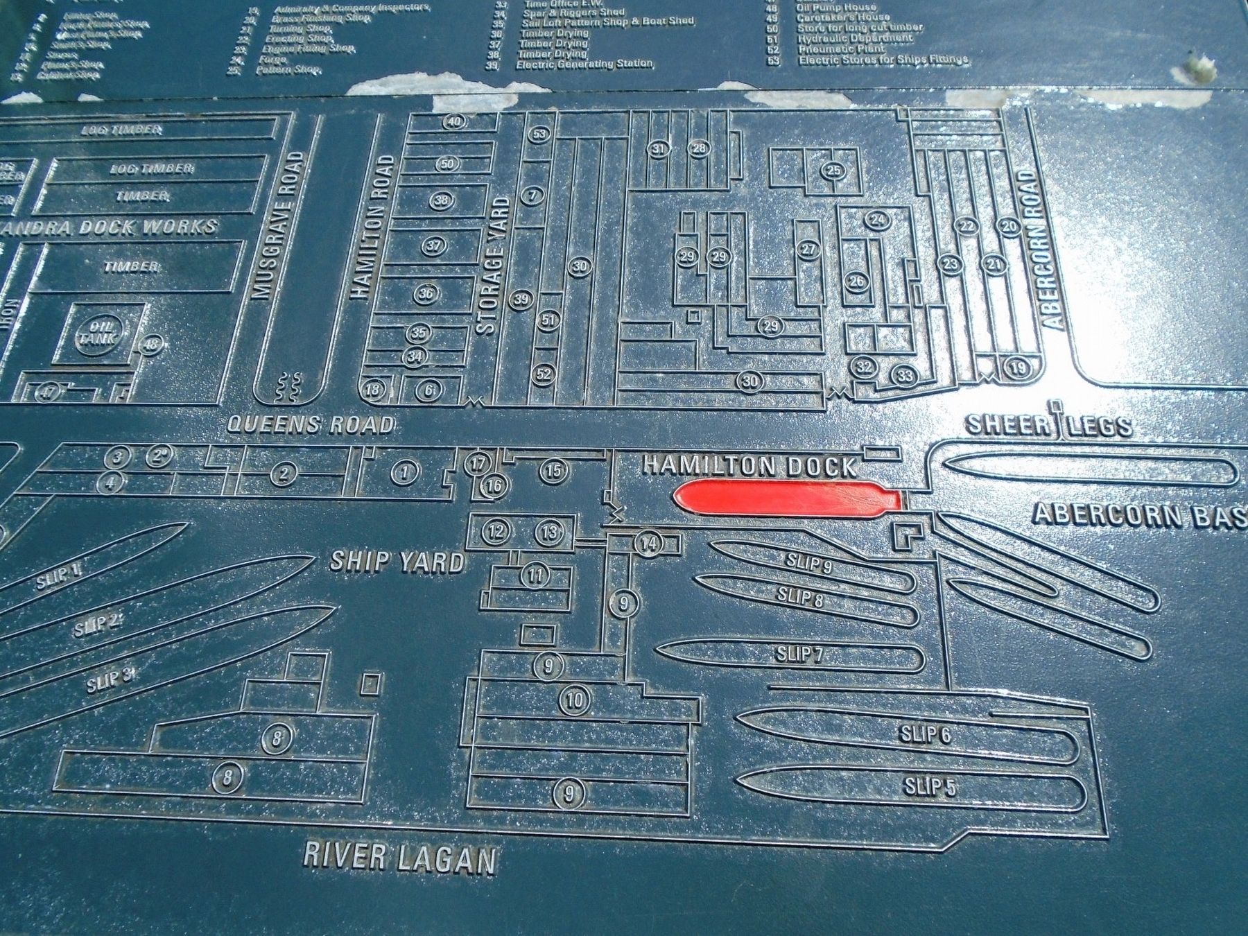
This plan shows the extent of Harland and Wolff's shipyard on Queen's Island in 1908. The Queen's Island shipyards were highly successful at this time; 247 ships were built on the island between 1900 and 1913, more than any other shipyard in the . . . — — Map (db m135267) HM
Broadcasting House on Ormeau Avenue is the home of the BBC in Northern Ireland. Designed in 1936 by James Millar of Glasgow, the imposing and austere neo-Georgian style is typical of the era. The frame is steel with reinforced concrete floors and . . . — — Map (db m134216) HM
Hamilton Graving Dock was continuously in use with ships being repaired, serviced or fitted out. It was leased by the Harbour Commissioners to Belfast's two main shipyards, Harland and Wolff and Workman Clark, as well as to ship owners. . . . — — Map (db m135388) HM
[Front]
Building the Dock 1864-1867
The construction of the dock began in February 1864 and was finished within three years. Four hundred and fifty men were employed to build the graving dock and the adjoining basin.
The . . . — — Map (db m135286) HM
[Front]
Building the Dock 1864-1867
The construction of Hamilton Dock began in February 1864 and was finished within three years.
[Top blue inset caption reads]
This is the office of the Deputy Harbour Master, whose . . . — — Map (db m135341) HM
Donegall Square is the heart of modern Belfast, centred on a grassy square occupied by the City Hall and surrounded by buildings in a wide variety of styles and from different periods. The buildings provide a microcosm of the city’s development, . . . — — Map (db m133769) HM
Donegall Square West is dominated by the magnificent Baroque-style Scottish Provident Institution (1902) that looks out over the City Hall (1906). Take a stroll around Donegall Square and discover architectural treasures such as the Linen Hall . . . — — Map (db m133768) HM
[Excerpts with historical information]
Belfast Harbour Commissioners' Offices
The magnificent office building of the Harbour Commissioners, who were responsible for the construction of Hamilton Dock in the 1860s, was first opened in 1854, . . . — — Map (db m135369) HM
This long three storey office building in sandstone and brick was the headquarters for Harland and Wolff. When this company was at its peak in the early to middle years of the 19th [sic - 20th] century, it was one of the mightiest shipbuilding . . . — — Map (db m135514) HM
Hamilton Graving Dock opened in 1867. It was almost twice the size of No. 2 Graving Dock which had been completed in 1826.
3 million gals
The dock holds approximately 3 million gallons of water, the same volume as five and half swimming . . . — — Map (db m135405) HM
To ensure good quality work,
the commissioners hired a mason
specialising in dock construction,
who was paid £2 5s 0d per week.
This was over four times the amount
a worker in a country mill earned.
—————————————— . . . — — Map (db m135284) HM
Only the very best quality stone
was used for dock construction.
The Belfast Harbor Commissioners visited
the site regularly to inspect progress.
——————————————
Irregular stonework was used to
strengthen the dock walls. . . . — — Map (db m135285) HM
Hamilton Dock was refurbished in 1948, when a new 25-inch (64cm) concrete floor was laid. It remained in use until the 1990s, but then fell into decline.
In 2009, work began to restore the dock, now a NIEA Scheduled Monument and the oldest . . . — — Map (db m135402) HM
Hamilton Graving Dock
The 450th long Hamilton Graving Dock (1863 - 1867) was the first graving dock to be built on the County Down side of the River Lagan. It is serviced by the 12 acres of sheltered water that form the Abercorn . . . — — Map (db m135446) HM
The names Edward Harland and Gustav Wolff are inextricably linked with Belfast's shipbuilding industry. Their partnership laid the foundations for what was to become one of the greatest shipyards in the world. To this day, Harland and Wolff's two . . . — — Map (db m135509) HM
[Historic photo captions read]
1. Murray's Tobacco Factory opened in 1901
2. Ulster Spinning Co. staff in the 1930s
3. Bill Hewitt, drum maker of Sandy Row
4. Workers at the Albion factory in 1919
5. Belfast City Tramways Training . . . — — Map (db m134119) HM
These blocks originally sat at the bottom of Hamilton Dock.
They were used to support ships' hulls.
You can see similar blocks under Nomadic's keel. — — Map (db m135404) HM
[Comments on monument, in no particular order]
The fastest growing section of the
labour force are married women in
part-time employment.
This work is only one part of a
mother's working day. . . . — — Map (db m134019) HM
This sculpture celebrates the female culture
and identity of Sandy Row
and the generational contribution women
have made to this community both in
the family and workplace.
Que Sera Sera
When I was just a little girl, . . . — — Map (db m134128) HM
From the mid 1800s, the Connswater was the driving force behind east Belfast's industrial growth. Barges laden with raw materials and goods travelled its length and its waters powered many cotton and flax mills, such as the Portview . . . — — Map (db m135564) HM
[Front]
The Olympic Slipway is where RMS Olympic was built beside her sister ship, Titanic. Although quiet and peaceful today, in 1910 this entire area was a hive of human industry, reverberating to the deafening din from steel plates being . . . — — Map (db m134902) HM
'Our harbour now stands among the finest in the United Kingdom.'
Belfast News Letter, 2 October 1867
Hamilton Dock was filled at high tide and emptied at low tide.
[Photo caption reads]
Above This cross-section . . . — — Map (db m135269) HM
[Front]
Queen's Island
From Pleasure Garden to Shipyard
Edward Harland and Gustav Wolff's shipyard, which would go on to become the most successful in the world, was established in 1861.
[Blue inset caption reads]
The . . . — — Map (db m135321) HM
[Front]
Queen's Island
From Pleasure Garden to Shipyard
Queen's Island was created in 1847 when slobs from the digging of Victoria Channel were deposited on the Co. Down side of the Lagan Estuary.
Queen's Island was . . . — — Map (db m135338) HM
This plaque was unveiled
on 31st March 2009
by
John M Andrews,
great nephew of
Thomas Andrews, Chief Naval
Architect, Harland & Wolff
to commemorate the
centenary of
the keel laying of
RMS Titanic
Built on this slipway . . . — — Map (db m134932) HM
'Belfaste is a place meet for a corporate town, armed with all commodities, as a principal haven, wood and good ground, standing also upon a border, and a place of great importance for service ...'
Extract from a letter to the Privy . . . — — Map (db m134933) HM
1922 The Shipyards Expand Eastwards
The First World War had been a period of frantic activity in the shipyards of Belfast, with orders for both new warships and running repairs to the fleet. In 1917, both Harland & Wolff and Workman Clark & . . . — — Map (db m135114) HM
Mayor of Belfast 1892 and 1893.
Lord Mayor 1901, 1902, 1903, 1905 and 1906.
Freeman of the City.
M.P. for Belfast-North-.
Obit 1907.
Erected by his many friends
in appreciation of the numerous
public services rendered
by him to the . . . — — Map (db m133963) HM
The dock was a hive of activity with up to two ships being worked on by large teams of men from the shipyards. The workers stood on wooden platforms called stages.
Brand new ships were also 'fitted-out' in the dock, with their final . . . — — Map (db m135397) HM
The pump house, built c.1867, contained the important machinery used to empty the dock of water. Inside the pump house was a boiler and a steam engine, which drove one underground centrifugal pump. A tall brick chimney - to release fumes and . . . — — Map (db m135437) HM
In the mid-1920s, the original steam-powered pumps were replaced by ones driven by electric motors.
Each of the 125 horsepower electric motors, which can still be seen inside, drives a pump in the underground well. Above the motors you can . . . — — Map (db m135438) HM
Welcome to the Quays at the mouth of the River Lagan. Set around the Lagan Weir the Quays incorporate Queen's Quay, Hanover Quay, Gregg's Quay and Donegall Quay, all closely linked with the origins of Belfast. The city derives its name from the . . . — — Map (db m135226) HM
KEY
(1) (2) The illuminated blue lines demonstrate the actual size and location of the Titanic (1) and Olympic (2) ships constructed on these two Slipways.
(3) The turfed and decked areas denote the proportions of people that survived . . . — — Map (db m135002) HM
[Front]
On 31 May 1911, SS 401, Titanic, slid down Slipway No. 3 at the Queen's Yard of Harland and Wolff and settled on the waters of the Victoria Channel in Belfast Lough. In her brief life she would be the largest, most luxurious vessel ever . . . — — Map (db m135088) HM
Belfast has been shaped by time and circumstance. Its buildings tell the story of change and development, of commerce and industry, entertainment and religion.
Belfast city centre is the vibrant heart of a thriving metropolis, which has shifted . . . — — Map (db m133803) HM
The Salmon
The natural life cycle of a salmon is one of nature's wonders. A salmon begins its life in the shallow water and gravel beds of the river as eggs then fry. These small fry stay in the river until they mature into par. The next . . . — — Map (db m70892) HM
The Giant’s Causeway railway provides a passenger link between the historic town of Bushmills and the famous basalt stone columns of the Giant’s Causeway World Heritage Site.
The Railway is an interesting heritage experience and travels along . . . — — Map (db m70850) HM
Side A
Welcome to Hamill Terrace
Renowned as the gateway to the Giant's Causeway and for the oldest licensed whiskey distillery in the world, Bushmills has a unique heritage of historic buildings and mills.
Images (clockwise . . . — — Map (db m70873) HM
The town of Garvagh owes its 17th century origins and subsequent development to the Canning family. George Canning was the first family member to come to Ireland when, in September 1614, he arrived at Agivey on the banks of the Bann as an agent . . . — — Map (db m70740) HM
Side A
Welcome to the historic town of Garvagh, situated on the banks of the Agivey River.
We hope you enjoy your visit. Please use the information and maps on this sign to find out about the history of Garvagh and to discover its . . . — — Map (db m70748) HM
In the early 1900s, Northern Ireland Railways were at their peak. They allowed fast and efficient transport of goods, mail and promoted local seaside resorts. They also established standard time.
From the early 1920s, road and air transport . . . — — Map (db m70902) HM
A night at Talbot's theatre
Actor/manager Michael Atkins opened the city's first purpose-built theatre at the top of Artillery Street in 1774. It soon became the fashionable place to be seen especially at grand social occasions when the . . . — — Map (db m71080) HM
Two million gallons of whisky
Smoke from illicit poteen whisky stills used to waft over the walls from the Bogside. Legal distilleries opened in the Waterside and in the Bogside in the 1820s. Watt's Abbey Street distillery became the . . . — — Map (db m70971) HM
This was one of the four original gates of 1617. It was initially called the 'Nugate' or King's Gate, later being renamed Butcher Gate after the nearby meat market and slaughterhouse. The gate was nearly destroyed by cannon fire during the 1689 . . . — — Map (db m70972) HM
The first shot
On 13th April, 1689 the first shot of the siege was fired. Citizens on the walls spotted the vanguard of the Jacobite army approaching under Lieutenant General Richard Hamilton. To make his presence known, Hamilton fired a . . . — — Map (db m71098) HM
You are standing on the city walls. Newmarket Street slopes up and over the wall. The street was created in the mid 19th century on the site of the Smithfield Meat Market to allow carts to the new covered market. — — Map (db m71100) HM
This was one of the four original 17th century gates to the city. It had a watch tower, battlements and a portcullis. The carvings on the outside of the present gate, built between 1803-5, celebrate the city's wealth. The cornucopia is a symbol of . . . — — Map (db m70927) HM
If 'stones could speak', what a story they would have to tell. Their voices still echo on the walls and in the city streets.
According to tradition St. Colm Cille chose the oak grove on top of the hill for his monastery in 546 AD. His . . . — — Map (db m70928) HM
[Keyed photo of Double Bastion overlook]
1. Lumen Christi College - co-educational school on the site of Bishop Hervey's casino.
2. The Windmill - the stump of the building fought over during the 1689 siege.
3. St Columba's, Long Tower . . . — — Map (db m71004) HM
Enamel colours have always been used to decorate pottery wares. Today they come processed but in early years of the Belleek Pottery they, along with most raw materials, were processed at the Pottery.
This particular grindstone was used to . . . — — Map (db m72561) HM
Beal Leice, meaning 'the mouth of the flagstone', lies in the most westerly point of Northern Ireland, hidden in the Erne valley between the Sligo mountains and the Atlantic. The village, which was first laid out during the Plantation of Ulster . . . — — Map (db m72553) HM
Thomas Mellon was born in this cottage on February 3rd, 1813. It was built by his father and uncle a few years earlier "chiefly by the labour of their own hands" and stood on a Twenty-three acre farm cut out of his grandfather's larger estate. . . . — — Map (db m85967) HM