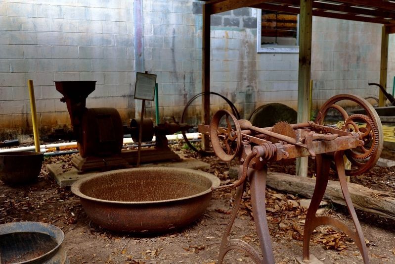
Far beneath parts of Clarke, Washington, and Mobile
counties sit vast deposits of salt. In some places, natural
springs bring salty water known as brine from this
enormous underground salt dome up to the surface.
For as long as this geological . . . — — Map (db m234677) HM
Front:
This Greek Revival style brick structure is known as the Hope Family Grave Shelter. Constructed in 1853, it is listed on the National Register of Historical places. The unusual splayed eaves and vaulted or “compass” . . . — — Map (db m47621) HM
This cabin was built in the 1830s by Josiah Mathews.
It is an example of a two-room log cabin. This type of cabin was commonly built by early 1800s settlers who came from the Carolinas and Georgia on the Federal Road to Clarke County. The cabin . . . — — Map (db m234676) HM
In erecting this marker the Clarke County Historical Society's sole purpose is to mark events and areas affecting the county's history.
Beat 15 of Clarke County, since the mid 19th century, came to be known as Mitcham Beat, named for an early . . . — — Map (db m203677) HM
Founded in 1809 by George Strother Gaines as Choctaw-Creek Indian Trading Post on Alabama River, now Gainestown Landing. Here lived Alabama Indians for whom State & River named. At Battle of Maubila De Soto's hogs escaped, from whence . . . — — Map (db m101609) HM
Born 1785 in Robeson County, N.C.
Came in 1818 to Monroe County, Alabama. Represented Monroe County in Alabama Constitutional Convention in 1819 and in State Legislature 1819-1822. Served as Governor of Alabama 1825-1829. Elected 1833 to Congress . . . — — Map (db m47637) HM
The Alston-Cobb House (c. 1854) is an example of plantation plain-style architecture, also called an "I" house because of its narrow profile. It is characterized by a simple gable roof. Typically, as in the Alston-Cobb House, there were masonry . . . — — Map (db m234674) HM
William Bartram, America’s first native born artist-naturalist, passed through Clarke County during the Revolutionary era, making the first scientific notations of its flora, fauna and inhabitants. As the appointed botanist of Britain’s King George . . . — — Map (db m101568) HM
“A man should be prudent and careful, without seeming to be so, in character, information, propriety, friends, and money, and in everything, never neglecting his friends.” Vardry McBee, 1852.
Entrepreneur, Philanthropist, . . . — — Map (db m125695) HM
On November 12, 1813, the Canoe Fight, one of the key assaults of the Creek War, took place nearby at the mouth of Randon’s Creek where it flows into the Alabama River. Following the Fort Mims Massacre in August, small bands of Creek warriors . . . — — Map (db m101574) HM
This marker stands inside the Mitchell Reserve, created Nov. 16, 1805 by the Treaty of Mount Dexter between the Choctaw Nation & the United States. The Reserve begins at a "post on the left bank of the Tombigbee River opposite the lower end of . . . — — Map (db m244880) HM
Established by Choctaw and Creek Indians about 1808 as the northern limit of boundary line between their lands. This line begins at the cut-off in South Clarke County, follows the watershed between Alabama and Tombigbee Rivers without crossing . . . — — Map (db m83271) HM
In 1916, a group of African American entrepreneurs formed the Coffeeville
Colored Industrial School (CCIS) to provide access to education for African
American children. CCIS classes were held in the Masonic Lodge until the
Coffeeville . . . — — Map (db m293762) HM
The town of Coffeeville began in 1808 as Murrell's Landing, a boat
landing and ferry crossing on the Tombigbee River. William Murrell
was a landowner and state representative for Clarke County. By
1819, the town had been renamed in honor of . . . — — Map (db m285143) HM
Near this site, is the gravesite of Maj. Jeremiah Austill, folk hero & prominent figure in the early settlement of Clarke County. Born in 1794 in S. C., he lived, along with his parents, Capt. Evan and Sara Austill, among the Cherokee in Ga. . . . — — Map (db m283128) HM
William E. Summers is inextricably tied to Texas history through his involvement with the election to name delegates to the Texas Independence Convention and in the fall of the Alamo as one of the Immortal 32. Summers family history can be traced . . . — — Map (db m293522) HM
Stephen J. Boykin was born in an unincorporated area in Wilcox County, Alabama around 1859. He was a self-educated man and worked early in his life as a laborer at a lumber mill. He married Carrie Taylor in 1906 and they raised eight children.
Mr. . . . — — Map (db m234961) HM
Northern Boundary of:
British W. Florida 1764-83
Spanish W. Florida 1783-95
Mississippi Territory: 1798-1804
Washington County 1800-12
Clarke County 1812-15
Southern Boundary of:
British Illinois 1764-83
United States . . . — — Map (db m73532) HM
Northern Boundary of:
British W. Florida 1764-83
Spanish W. Florida 1783-95
Mississippi Territory: 1798-1804
Washington County 1800-12
Clarke County 1812-15
Southern Boundary of:
British Illinois 1764-83
United States . . . — — Map (db m89725) HM
Thin black lines indicate changes in relevance. Between each pair of lines entries are ordered geographically but all have the same relevance.
* Inflectional forms of words are their plurals, singulars, and possessives as well as gramatical tenses and similar variations.