New Kent County. Area 191 Square Miles. Formed in 1654 from York, and named for an English county. The White House, where Washington's wife lived, was in this county, and here he married her.
James City County. Area . . . — — Map (db m29299) HM
John Smith explored the upper Chickahominy River in December 1607. He left his boat and seven of his crew at Apocant, the highest town on the river in the upper part of what is today the lake. Two crew members departed with Smith and two . . . — — Map (db m61883) HM
As part of the State's effort to restore Virginia's native longleaf pine, the Poquoson Museum in partnership with the York/Poquoson Master Gardeners and the Virginia Department of Forestry have planted this plot of native longleaf pines. . . . — — Map (db m302071) HM
The marker is made up of two panels Since there is little natural stone in tidewater Virginia, tombstones were rare in the seventeenth and eighteenth centuries. Almost all had to be imported, usually from England. Many of the people buried . . . — — Map (db m100102) HM
(left panel)
Sustaining a Credible Illusion
The Jamestown settlement was facing a severe food shortage in November of 1607. Captain John
Smith set out to trade for corn with the Indians living along this river. He traveled from . . . — — Map (db m46511) HM
Surry County. Surry County, named for the county of Surrey in England, was formed from James City County about 1652. The Quiyoughcohannocks, whose villages were primarily situated in present-day Surry County, were among the first Virginia . . . — — Map (db m2680) HM
You are walking on historic ground! This 601-acre park includes a 17th-century James City County homesite, an 18th-century graveyard, and America's earliest known free black settlement, dating to 1803. In addition Continental, French and British . . . — — Map (db m231288) HM
Due to the loss of James City County records during the Civil War, little is known about this early 19th-century cottage. Actor Cary Grant resided here while starring in the Hollywood film The Howards of Virginia in 1940. — — Map (db m228019) HM
(left panel)
Sustaining Courage for Exploration
In December 1607 John Smith set out from Jamestown to continue his exploration of the Chickahominy River, which had begun with a series of trading voyages in November. He visited . . . — — Map (db m83910) HM
(side 1)
The Colonial River Road
After centuries of use by native people and the colonists of New Kent County, the road along the Pamunkey River was extended past the tobacco ports of Newcastle and Page’s Warehouse (later . . . — — Map (db m53801) HM
The foundations of the multi-dwelling structure that stood here match the dimensions called for in legislation passed by the General Assembly in September 1662. This row rouse was standing by September 1668 when the justices of James City . . . — — Map (db m17320) HM
A perpetual Conservation Easement between James City County, the Army Corps of Engineers and the Williamsburg Land Conservancy protects approximately 100 acres of wetlands. Wetlands include swamps, marshes and bogs that typically support vegetation . . . — — Map (db m295131) HM
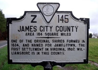
James City County. Area 164 Square Miles. One of the original shires formed in 1634, and named for Jamestown, the first settlement in Virginia, 1607. Williamsburg is in this county.
York County. Area 186 Square . . . — — Map (db m73950) HM
Archaeological Analysis
Freedom Park is located on part of the Hot Water Tract, which totaled approximately 1,782 acres. This cemetery contains the remains of at least 160 people. Burials of infants, children and adults were discovered at . . . — — Map (db m295084) HM
The Norge Depot was built sometime between 1906 and 1908 by the Chesapeake and Ohio Railroad Company. This building is the only surviving example in James City County of the company's trend towards standardized designs for the mass production of . . . — — Map (db m270978) HM
The 2019 restoration of Jamestown's Memorial Church was made possible thanks to the generosity of the following friends:
The General Society of Colonial Wars
James City County
The Jamestowne Society
The National Society of the Colonial . . . — — Map (db m305080) HM
William Ludwell Lee of Green Spring Farm died in 1803. A year earlier he had written his will and bequeathed freedom to his slaves. He specified that comfortable homes be built for them on "the Hotwaters," a subsidiary farm about four miles north . . . — — Map (db m226527) HM
The historic Lee Hall Depot was constructed in the 1880s as part of the Chesapeake and Ohio Railway’s efforts to establish its Atlantic terminus at Newport News, thereby linking the Ohio River Valley with the sea. The station was sited on Warwick . . . — — Map (db m34000) HM
Two African American Civil War veterans, Pvt. Edward Diggs and Sgt. Anthony W. Poole, are buried here. Each enlisted in Co. G, 36th U.S. Colored Troops, in Yorktown. Blacks sought to enlist earlier in the war but were banned until after the . . . — — Map (db m66890) HM
In the summer of 1781, thousands of troops crisscrossed the James City County countryside, foraging for food and strategically moving toward Yorktown. Although neither side knew the other’s strength, Lafayette saw an opportunity to attack. . . . — — Map (db m194749) HM