On East Glen Avenue just east of North Maple Avenue, on the right when traveling west.
This colonial road, traditionally an Indian Trail, was a key route to Peremus Church during the American Revolution. Former names of this road mark eras in America’s history – Franklin Turnpike, for the Tory governor Wm. Franklin; Harrison . . . — — Map (db m18688) HM
On W. Ridgewood Avenue near 305 W. Ridgewood Avenue, on the right when traveling west.
Built about 1869 in the late Italianate style of architecture, it was the summer home of Joseph H. Chapman who was a Wall St. insurance agent. In 1868 a group of investors laid out streets and house lots and named the development Ridgewood Park. . . . — — Map (db m24986) HM
On E Glen Avenue, on the right when traveling east.
Organized in 1725 by pioneer Dutch settlers, the congregation of this church has worshipped here over 240 years. First church, built 1735 on this land given by Peter Fauconier, a French Huguenot, was a headquarters of Gen. George Washington in . . . — — Map (db m24983) HM
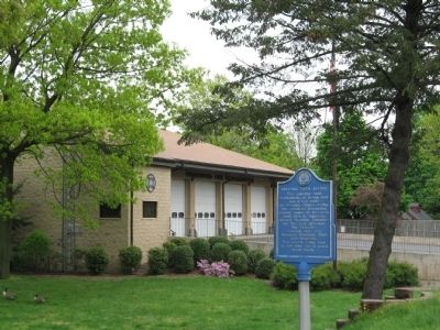
On E Glen Avenue, on the left when traveling west.
Built in 1872, this school is believed to be the fifth one erected on Paramus Reformed Church ground. From 1730 to the 1870s, education was carried on by the church. Rented to Ridgewood Township, it became District School No. 45 from the 1870s to . . . — — Map (db m24985) HM
On Grove Street at Arcadia Road, on the left when traveling east on Grove Street.
Located on property purchased by Garret Van Dien about 1713, this house was built by a descendant, and is a combination of 18th and 19th century architecture. It has been enlarged over the years and remained in the Van Dien family until 1900. — — Map (db m24987) HM
On Tenney Avenue at Kindermkerack, on the right when traveling west on Tenney Avenue.
Sections were once known as Kindermack, Steenrapie, Old Bridge and New Bridge. George Washington, in 1776, retreated across New Bridge and the hill above was fortified by the British in 1778. In 1780 the Americans encamped in town with the HQ of . . . — — Map (db m36452) HM
Site of the Zabriskie Grist Mill and wharf near the head of navigation on the Hackensack River. Farm produce and iron from the Ramapo Mts. were shipped from here to market. The mill, once powered by the tides, burned in 1852 after a century of . . . — — Map (db m7468) HM
This Dutch Style sandstone house had stood in New Milford since the Revolution. Faced with demolition it was saved for our country’s heritage by moving it to this site on September 27, 1977. This preservation was accomplished through the combined . . . — — Map (db m7465) HM
Erected 1752 and presented to Maj. Gen. Von Steuben by the State of New Jersey 1783 in recognition of New Jersey’s share of the debt which the nation owed the General. — — Map (db m51303) HM
On Red Oak Drive at Rivervale Road, on the right when traveling east on Red Oak Drive.
In memory of American soldiers killed during the Revolutionary War in the “Baylor Massacre” on September 28, 1778. Lt. Col. George Baylor’s 3rd Regiment of Continental Dragoons took quarters for the night on several nearby farms. Tories betrayed . . . — — Map (db m7874) HM
On Rivervale Road at James Lane, on the left when traveling north on Rivervale Road.
Built about 1828 by David C. Blauvelt on land he purchased in 1801. The 37 acre farm was situated in the locality once known as Overkill Neighborhood. David was a blacksmith and after his death, son John D. Blauvelt bought the homestead in 1842. He . . . — — Map (db m7943) HM
On Rivervale Road at Prospect Avenue, on the left when traveling north on Rivervale Road.
Built about 1784 by William Holdrum, Jr., a farmer who inherited a 116 acre tract from his father, William Holdrum, Sr., the present structure was built as an addition to the 1765 house of Johannes Mabie, Holdrum enlarged the dwelling to the west . . . — — Map (db m7945) HM
On Piermont Road (County Route 501), on the right when traveling south.
Erected on a 200 acre farm by Abraham A. Haring, a captain in the Bergen County Militia. During the Revolutionary War, Haring was captured by the British and imprisoned in New York City where he died. In 1805 his grandson, Abraham D. Haring, sold . . . — — Map (db m8685) HM
On Rockleigh Road, on the left when traveling north.
Built about 1796 by Jacob Concklin, Jr., a “wheelwright”, the house is an example of Dutch Colonial architecture. Erected on the site of an earlier Concklin homestead, it stands on a 166½ acre farm purchased in 1748 by Jacob . . . — — Map (db m52946) HM
On Piermont Road (County Route 501), on the right when traveling south.
An early 19th century example of Dutch Colonial architecture erected by John A. Haring. Small wing added c. 1808; rear stone section built by a Haring about the time of the Revolutionary War. Inherited in 1854 by son Nicholas J. Haring, the . . . — — Map (db m8686) HM
On Rockleigh Road near 31 Rockleigh Road, on the left when traveling north.
Erected by Joseph Dubois in the locality once known as Rockland Neighborhood. South wing built in 1835, with materials from 18th century house of John Gesner. Center section built soon after with Victorian porch and north wing added at a later . . . — — Map (db m8680) HM
On Piermont Road (County Route 501), on the left when traveling north.
First named Carterette Road, this section, from Rockleigh Road to the state line, was constructed in 1859 as an extension of the road from Closter. For local farmers it was an easier wagon route to New York State and for carrying produce to the . . . — — Map (db m8631) HM
On Rockleigh Road, on the right when traveling north.
In 1685 this land was granted by New Jersey to George Lockhart and confirmed in 1687 by New York when that Province governed this area. It remained under New York jurisdiction until 1769 when the boundary dispute between the two colonies was . . . — — Map (db m8633) HM
On Rockleigh Road at Piermont Road (County Route 501), on the right when traveling north on Rockleigh Road.
A colonial road that led from Closter to Snedens Landing – the western terminus of Dobbs Ferry on the Hudson. Part of this road was built by New York in 1748 when that Province governed this area. Used by troops during the Revolutionary War. . . . — — Map (db m8632) HM
On Chestnut Ridge Road near Woodcliff Lake Road, on the right when traveling north.
Built circa 1802 by Abraham P. Ackerman who added stone kitchen wing soon after. Later, son William built frame unit. His son Abraham W., owner in 1875, remodeled house and added mansard roofs. The farmhouse remained in the Ackerman family until . . . — — Map (db m29878) HM
On W. Saddle River Road at E Allendale Road, on the right when traveling south on W. Saddle River Road.
Built around 1835 in the Greek Revival style, it incorporates parts of a late 18th c. home. John D. Ackerman was a miller and his son, David I., was a blacksmith who built a trip hammer forge on the Saddle River opposite the house. His grandson, . . . — — Map (db m29877) HM
On Teaneck Road at Copley Avenue, on the left when traveling south on Teaneck Road.
This old house was built around 1735 by Hendricks Brinkerhoff on land owned by his grandfather since the 17th century. An excellent example of early Dutch Architecture, it has been in the possession of the Brinkerhoff and Demarest descendants since . . . — — Map (db m7224) HM
On Teaneck Road at Cedar Lane, on the right when traveling south on Teaneck Road.
Troops of the American army camped in this vicinity from August 22 to September 3, 1780, in order to forage for food and horses. The encampment extended to the north and east of Teaneck Road for about two miles. Situated near British-held New York . . . — — Map (db m7221) HM
Built about 1867 for the Charles J. Everett family, this house was designed by famous architect Richard Morris Hunt in the Swiss Chalet style. Everett was noted as an inventor. In 1919 it became the home of Harvey Dunn, a prominent artist whose . . . — — Map (db m7484) HM
On Westervelt Ave east of Tenafly Road, on the right when traveling east.
This house is a fine example of Dutch Colonial architecture. The south wing of the house was built by Roelof Westervelt in 1745. The land had been purchased by his grandfather, in 1695, from the Lord Proprietores of East Jersey. The central section . . . — — Map (db m7210) HM
On Jefferson Ave south of Newcomb Road, on the left when traveling north.
Stands on land purchased by William P. Christie for 500 pounds for 100 acres. In 1804 he built his home. Following his sudden death, in order to be fair to the many heirs, the house and the land were sold at auction to three buyers. In 1836 Samuel . . . — — Map (db m7209) HM
On Piermont Road, on the right when traveling south.
Built in 1872 when George Huyler donated the land and a third of the cost. Residents and the Northern Railroad of New Jersey shared equally in the balance. Designed in High Victorian Gothic by Architect Daniel T. Atwood, the station opened in 1874 . . . — — Map (db m7211) HM
On Industrial Avenue, on the right when traveling north.
The home of Gates Flying Circus. Teterboro built Fokker tri-motors flown by Richard E. Byrd over the North Pole (1926); South Pole (1929); Atlantic (1927); and by Amelia Earhart over Atlantic (1928). Clarence Chamberlin, Ruth Nichols, Floyd . . . — — Map (db m6863) HM
On Ridgewood Road east of Pascack Road, on the left when traveling east.
Oldest house in Washington Township, built by Nicholas Zabriskie about 1750. Wings added after 1770 and second story frame raised above original native sandstone in 1812. Tradition says house was an Underground Railway depot for escaping slaves . . . — — Map (db m43780) HM
On East Saddle River Road at Lake Street, on the right when traveling south on East Saddle River Road.
Abraham Hopper built a “new stone house” here (the west wing) in 1739, according to surveyor Charles Clinton. The rest is late 18th century. About 1813 it was bought by the Rev. Stephen Goetschius (1752 – 1837), pastor of Old . . . — — Map (db m29905) HM
On East Saddle River Road at Old Stone Church Road, on the right when traveling south on East Saddle River Road.
Known as The Old Stone Church It has been ministering to this area since 1784. The present structure of native stone was completed in 1819. Buried here are: The Rev. Stephen Goetschius minister 1819-1835 The Rev. Dr. Isaac Van Kampen minister . . . — — Map (db m29899) HM
On Knights Court west of Saddle River Road, on the left when traveling west.
Known by this name for generations, it once was part of the Hopper family farm. Believed to have been a burial ground for slaves and freed blacks, there once were many stones, most without marks. In 1910, the surviving stones with inscriptions were . . . — — Map (db m29909) HM
On First Avenue at Mill Street, on the right when traveling north on First Avenue.
Near here on Musquapsink Brook stood the earliest grist mill in Pascack built 1734 by Rev. Johannes Bernardus Van Dierren, a Lutheran Pastor. In 1765 it was purchased by Isaac Bogert and owned by his descendants until destroyed by fire in 1910. . . . — — Map (db m43779) HM
On Pascack Road at Edge Hill Court, on the left when traveling north on Pascack Road.
This sandstone and frame house was built about 1794 by Peter P. Post, a third generation miller from Pompton, who settled here in 1789 and operated a gristmill along nearby Bear Brook. Later owners included the Abraham J. Demarest family who were . . . — — Map (db m43841) HM
On Pascack Road at Woodcliff Avenue, on the right when traveling north on Pascack Road.
Frederick Wortendyke IV built this house between 1812 – 1825 to replace an older home near-by. It stands on land purchased in 1775 by his grandfather Frederick Jr. of Park Ridge. The family operated a general store on the opposite side of . . . — — Map (db m22252) HM
On Hackensack Street at Highland Ave., on the left when traveling north on Hackensack Street.
Located in old “Polifly”, George Brinkerhoff built this house about 1792 on a 200 acre farm he purchased in 1784. Owned in 1806 by son Henry G. and in 1849 by his son, Enoch, a N.J. Assemblyman. In the 1870’s, great-grandson Henry E. remodeled the . . . — — Map (db m6865) HM
On Sicomac Avenue, on the right when traveling west.
Erected about 1812 by John C. Stagg on site of earlier building owned by his father, Cornelius Stagg, a veteran of the Revolutionary War. The basement was operated as a grocery store for many years by John C. Stagg. His son, Albert, sold to Richard . . . — — Map (db m12404) HM
On Franklin Avenue at Maple Avenue, on the right when traveling west on Franklin Avenue.
Built in 1824 by Albert Van Voorhees, this Federal home replaced his earlier house. The land, owned by father William since 1720, was called “Wikehoff”. Albert, a veteran of the Revolution and a Justice, deeded the new home to grandson Albert J. . . . — — Map (db m12407) HM
On Wyckoff Avenue, on the right when traveling north.
Once known as the Reformed Dutch Church of Wyckoff, this was the first church to be erected in the Township. It was established by members of Ponds Church at Oakland who lived in this area. They constructed the building of local stone and timber on . . . — — Map (db m12403) HM
139 entries matched your criteria. Entries 101 through 139 are listed above. ⊲ Previous 100