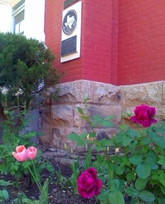
On North 6th Street at West Avenue E (U.S. 67/90), on the right when traveling south on North 6th Street.
Building erected in 1887 when Brewster County was created. Served Buchel and Foley Counties until these areas where added to Brewster County. Courthouse Square still is community center for various events.
Recorded Texas Historic Landmark . . . — — Map (db m61016) HM
On U.S. 67/90 at Paso del Norte Road on U.S. 67/90.
1475 CE* 1492 - Columbus lands on San Salvador Island in the Caribbean West Indies 1497 - John Cabot, first known English party to land in North America, northeast Canada 1521 - Hernán Cortés conquers the Aztec Empire 1528 - Panfilo de Narváez . . . — — Map (db m160836) HM
On State Highway 118 2.9 miles south of Farm to Market Road 170, on the right when traveling south.
Everett Ewing Townsend, called the "father of the Big Bend National Park," was instrumental in initiating, promoting and finally bringing into reality the idea of a public park along the Big Bend of Texas' Rio Grande.
Townsend was born on . . . — — Map (db m218918) HM
On U.S. 67/90 at Paso del Norte Road, on the left when traveling east on U.S. 67/90.
1680 CE*
1683 – Juan Domínguez de Mendoza leads first expedition to La Junta de los Rios in 95 years
1693 – Juan Fernández de Retana leads expedition to protect native Jumano Indians from Apache Indian raids at La Junta . . . — — Map (db m160837) HM
On South Walker Street (State Highway 118) 1.4 miles south of East Gallego Avenue, on the right when traveling south.
Early Human History in the Big Bend Region
Historic Period - AD 1535 - The first Spaniards entered the Big Bend beginning with Cabeza de Vaca in AD 1535. Spanish entradas in the late 1500s and 1600s led to the establishment . . . — — Map (db m220415) HM
On North 6th Street at West Sul Ross Avenue, on the right when traveling south on North 6th Street.
This marble slab and tablet carries our message of grateful remembrance for their interest in and courage to seek a home site in this rugged, yet beautiful range of mountains and valleys. Most of our pioneers came in the eighties and it can be said . . . — — Map (db m61048) HM
On Terlingua Ghost Town at Ivey Road, on the left when traveling north on Terlingua Ghost Town.
To a Modern Observer, living conditions in early 20th century Terlingua may seem primitive, even brutal. For immigrant miners, Terlingua and the Chisos Mine offered a distinct improvement over their native Mexico, which was torn by political . . . — — Map (db m220385) HM
Called San Lorenzo by Juan Domínguez de Mendoza, 1684. Later Charco de Alzate in honor of an Apache chieftain. After Civil War given name of Burgess' water hole honoring John W. Burgess, pioneer freighter, who here outwitted the Apaches. The . . . — — Map (db m26390) HM
On West Sul Ross Avenue/West Avenue E at North 7th Street, on the right when traveling east on West Sul Ross Avenue/West Avenue E.
[Bottom plaque]
This building is the original Brewster County Jail. Completed in 1888, the old jail was subsequently modified on numerous occasions to meet various requirements of the State of Texas. In 1995, upon completion of a new . . . — — Map (db m195517) HM
On State Highway 170 west of Comanche Mesa, on the right when traveling west.
Lajitas, the Spanish word for flagstone, comes from the Boquillas Geologic Formation. Located near the Lajitas Crossing/San Carlos ford on the Rio Grande, the Lajitas cemetery has been in use since at least the early 1900s. For millennia, the ford . . . — — Map (db m170662) HM
Near West Sul Ross Avenue at North 8th Street, on the right when traveling east.
This tablet is dedicated
to the men & women
of
Brewster County
in grateful recognition
of their patriotic
service to our country
in times of war
Erected AD 1948
by
American Legion Auxiliary
Big Bend Unit No. 79
Alpine, . . . — — Map (db m61354) WM
The northern, or "highland",
region of Brewster County has
the highest average elevations
in the County, ranging from
3,700 up to 6,000 feet above
sea level. Lower temperatures
and slightly increased rainfall
contribute to open . . . — — Map (db m163876) HM
Transportation
In the thirty years following the Civil War, massive trail drives brought more than 10
million cattle to markets in the Midwest. Driving herds
across country was time-consuming and expensive in staff, supplies and wear on . . . — — Map (db m163874) HM
On State Highway 118 at Farm to Market Road 170, on the right when traveling south on State Highway 118.
The southern region of Brewster County is characterized by rough terrain and low elevations with higher temperatures and less rainfall than in other parts of the County. As a result, only the hardiest of cattle can thrive here.
Border . . . — — Map (db m218777) HM
On State Highway 118 at Farm to Market Road 170, on the right when traveling south on State Highway 118.
Transportation
In the thirty years following the Civil War, massive trail drives brought more than 10 million cattle to markets in the Midwest. Driving herds across country was time-consuming and expensive in staff, supplies and wear on the . . . — — Map (db m218636) HM
Thin black lines indicate changes in relevance. Between each pair of lines entries are ordered geographically but all have the same relevance.
* Inflectional forms of words are their plurals, singulars, and possessives as well as gramatical tenses and similar variations.