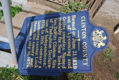
On North Jay Street (Pennsylvania Route 120) at East Water Street, on the right when traveling south on North Jay Street.
Formed on June 21, 1839 out of Lycoming and Centre counties. Named probably for New York's Gov. DeWitt Clinton. Site of "Tiadaghton Declaration of Independence," 1776. In 19th century a lumbering center. Lock Haven, the county seat, became a city . . . — — Map (db m65547) HM
A journey down the West Branch tells the tale of lumbering in Pennsylvania, from the early lumber mills to today's sustainable forests. As you float downstream you will see the legacy of lumber; the "rafting points" used by river pilots to navigate . . . — — Map (db m87639) HM
On Front Street (Pennsylvania Route 153) just north of Locust Street, on the right when traveling south.
A journey down the West Branch tells the tale of lumbering in Pennsylvania, from the early lumber mills to today's sustainable forests. As you float downstream you will see the legacy of lumber; the "rafting points" used by river pilots to . . . — — Map (db m251275) HM
A journey down the West Branch tells the tale of lumbering in Pennsylvania, from the early lumber mills to today's sustainable forests. As you float downstream you will see the legacy of lumber; the "rafting points" used by river pilots to . . . — — Map (db m263023) HM
Near South Water Street (Pennsylvania Route 550) south of West High Street, on the right when traveling south.
Welcome to Bellefonte, the county seat of Centre County and one of the "Gateways" into the Lumber Heritage Region of Pennsylvania. The history of lumbering in Centre County can be divided into four phases. The earliest lumbering operations were . . . — — Map (db m134708) HM
On Curtin Road (Pennsylvania Route 1003) 0.2 miles south of Eagle Valley Road ( Route 150), on the left when traveling south.
1810 Irish immigrant Roland Curtin Sr. and Cumberland
County native Moses Boggs establish Eagle Forge (iron refinery)
near Philip Antes' grist-and-lumber mills 1,000 feet northwest
of this spot, on the south side of Bald Eagle . . . — — Map (db m275201) HM
On Front Street (Pennsylvania Route 153) at Locust Street, on the right when traveling south on Front Street.
When pioneers ventured into northwestern
Pennsylvania in the early 1800s, they
encountered a daunting landscape
blanketed by dense, dark, ancient forests
unlike any they had encountered in New
England or eastern Pennsylvania. In . . . — — Map (db m251181) HM
On Interstate 80 at milepost 194, on the right when traveling west.
Timbering — Clinton County, at one time of settlement was considered one of the most remote parts of Pennsylvania. It is likely that during this early time most of the area was densely covered with white pine, eastern hemlock, and hardwoods . . . — — Map (db m176028) HM
On Interstate 80 east of East Valley Road, on the right when traveling east.
Timbering — Clinton County, at one time of settlement was considered one of the most remote parts of Pennsylvania. It is likely that during this early time most of the area was densely covered with white pine, eastern hemlock, and hardwoods . . . — — Map (db m282643) HM
On Barners Church Road (County Road 1004) at Barners Road, on the left when traveling north on Barners Church Road.
Migrated from Switzerland in 1758, locating between Philadelphia and Lancaster…
In 1767, he settled on the farm on which Barner's Church is now located…..
He married the widow of John Bunn. They had two sons. One son, Henry Barner, . . . — — Map (db m253347) HM
Near Franklin Street (U.S. 50) 0.2 miles east of 1st Street, on the left when traveling east.
The Goshen Road was one of the earliest roads in Clinton County and was traveled by its first settlers. The original road was blazed by wild animals and Native Americans. The first record of its use, however, was in 1808 when its course was mapped . . . — — Map (db m98931) HM
Near Lincoln Highway (U.S. 30) just west of Monroe Avenue, on the right when traveling west.
In 1912, there were approximately one million motor vehicles registered in the United States but few good roads. Most of the roads outside of urban areas were dirt that turned to mud when wet. Long-distance travel by car was still very much a . . . — — Map (db m162418) HM
On Ohio Route 73 just west of Collett Road (County Route 232), on the right when traveling east.
Jonah’s Run Baptist Church.
The comingling of faiths in an area settled predominantly by
Quakers helps explain the origins of Jonah’s Run Baptist Church.
Ministered to by a Baptist preacher, the children and neighbors of
Daniel Collett . . . — — Map (db m141498) HM
On Jay Street (Pennsylvania Route 664) at Water Street, on the right when traveling north on Jay Street.
Lock Haven...looking to the future, warmly remembering its past!
Nestled between the West Branch of the Susquehanna River and the scenic mountains of Central Pennsylvania, Lock Haven has small town charm and a rich historical architectural . . . — — Map (db m251748) HM
On Water Street (Route 120) near Jay Street (Route 664), on the right when traveling west.
During the American Revolution (1775-83),
what is now Clinton County was the
northern frontier of Northumberland
County. In 1776, William McElhattan,
Robert Love, William Dunn, and many
others answered the call for independence
and reported . . . — — Map (db m275118) HM WM
Thin black lines indicate changes in relevance. Between each pair of lines entries are ordered geographically but all have the same relevance.
* Inflectional forms of words are their plurals, singulars, and possessives as well as gramatical tenses and similar variations.