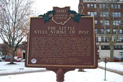
Near 1st Street SE at Diamond Court SE, on the right when traveling north.
During the New Deal of the 1930s, the Congress of Industrial Organizations (CIO) formed the Steel Workers Organizing Committee (SWOC) under the leadership of CIO president John L. Lewis. Following successful CIO strikes in the rubber and . . . — — Map (db m80719) HM
William McKinley’s house, once located at this site, was the scene of his 1896 “front porch campaign” for President of the United States. During the campaign McKinley addressed about 750,000 people who came to his home in Canton. . . . — — Map (db m67418) HM
Near Erie Avenue Northwest at Millfield Road Northwest, on the right when traveling east.
Did you know before canals Ohio's main form of transportation was by horse and wagon? The Ohio & Erie Canal formed an early shipping route connecting Lake Erie to the Ohio River. This canal system linked Ohio to the rest of the nation.
Lock 4 . . . — — Map (db m247153) HM
On South High Street at Church Street, on the right when traveling north on South High Street.
On December 30, 1847, six educators met at the Summit County Courthouse to organize the first convention of the Ohio State Teachers' Association, now known as the Ohio Education Association (OEA). The organizers Josiah Hurty (Richland County), . . . — — Map (db m299758) HM
On Erie Street South, on the left when traveling north.
During the Civil War in 1863, twenty-year-old Massillon farmer Robert Pinn enlisted in the 5th Regiment, Company 1, United States Colored Troops (USCT) at his first opportunity, saying "I was very eager to become a soldier, in order to prove by my . . . — — Map (db m61478) HM
As a member of the 2nd Ohio Volunteer Cavalry that fought at the Battle of Sailor's Creek in Virginia on April 6, 1865, the last major battle of the Civil War, Private William Richardson was personally recommended by General Phillip Sheridan to . . . — — Map (db m62811) HM
A soldier in Company A, 148th Infantry, 37th “Buckeye” Infantry Division. Cicchetti was part of the assault on the first important line of Japanese defense at South Manila, Luzon, Philippines on February 9, 1945. He died of wounds . . . — — Map (db m62686) HM
On Baltimore Pike (State Highway 97), on the right when traveling north.
(Front):4th Ohio Infantry. 1st Brigade, 3rd Division, 2nd Corps. Carroll's Brigade. Ohio's Tribute. (Left):On the evening of July 2, 1863. Carroll's Brigade was sent from its position with the 2nd Corps to re-enforce this position of . . . — — Map (db m16945) HM
On Long Judson Road (County Road 79) 0.3 miles east of Beaver Creek Road (County Road 203), on the left when traveling east.
The Long-Judson Parker pony truss bridge was designed by R. M. Strohl of Clague and Strohl Company, Bowling Green, Ohio and built by the Elkhart Bridge & Iron Company of Elkhart, Indiana in 1916. It carried Wood County's Township Road 79A . . . — — Map (db m185134) HM
Near South Webb Street at Ash Street, on the right when traveling east.
The coming of the railroads to Alliance is an important event in Stark County's history. In 1851, the Cleveland & Pittsburgh Railroad (running SE to NW) and the Ohio & Pennsylvania Railroad (E to W) intersected at this location. It was known as . . . — — Map (db m124238) HM
On 1st Street Southeast at Tremont Avenue Souteast, on the right when traveling north on 1st Street Southeast.
First Sergeant, Company I, 5th U.S. Colored Troops.
19th Black Recipient
Born March 1, 1843, Stark County, Ohio. Died January 1, 1911 Buried Massillon City Cemetery, Massillon, Ohio. Entered service at Massillon, OH. At Chapins Farm, Fort . . . — — Map (db m273273) HM WM
On Ohio Turnpike (Interstate 80 at milepost 197), 3 miles east of Painesville Ravenna Road ( Route 44), on the right when traveling west.
The Underground Railroad
The Underground Railroad was neither underground nor a railroad, but a system of loosely connected safe havens where those escaping the brutal conditions of slavery were sheltered, fed, clothed, nursed, concealed, . . . — — Map (db m189183) HM
The Underground Railroad
The Underground Railroad was neither underground nor a railroad, but a system of loosely connected safe havens where those escaping the brutal conditions of slavery were sheltered, fed, clothed, nursed, concealed, . . . — — Map (db m207605) HM
On Market Avenue South south of Tuscarawas Street West, on the left when traveling south.
Canton City Solicitor (Law Director) 1951-1960
Judge, Court of Common Pleas, Stark County 1969-1971
U.S. District Judge, Northern District of Ohio 1971-1982
U.S. Circuit Judge, Sixth Circuit 1982-2000
Judge Leroy J. . . . — — Map (db m137911) HM
On Boston Mills Road. Reported permanently removed.
The Ohio & Erie Canal is an early 19th-century creation built to meet growing transportation needs. The Towpath Trail is a late 20th-century creation, built because visionary individuals saw new uses for the abandoned canal. One of these . . . — — Map (db m224613) HM
James Clyman - Trapper and Explorer. Prominent in opening the Far West. He was with Jedediah Smith in 1824 at South Pass. Prepared the way for the pre-Gold Rush pioneers. Settled in Napa County in 1848. — — Map (db m54549) HM
On Summit Street, on the right when traveling north.
Civil War
Brown, Wilson, W. Co. F, 21st Ohio Infantry, Private, Army. Born; December 25, 1837 in Logan County, Ohio. Entered service in Wood County, Ohio. Died; December 25th, 1916, in Toledo, Ohio. Buried at New Belleville Ridge Cemetery, . . . — — Map (db m160385) WM
On Tuscarawas Street Northwest 0.2 miles south of Cherry Street West, on the right when traveling south.
The Dream
Who will be the first to build a canal boat? That was the question asked by Al Simpson in his "Along the Towpath" column which appeared every Sunday in the Canton Repository. Simpson had accompanied Ralph Regula on a hike along the . . . — — Map (db m246695) HM
On Everett Road 0.2 miles south of Oak Hill Road, on the right when traveling east.
Congressman Ralph Regula valued Cuyahoga Valley
National Park because it provided open space for outdoor
recreation. He supported the park as a place that could be
visited more affordably and frequently than remote western
national parks, and . . . — — Map (db m166152) HM
On West 18th Street at Baynard Boulevard on West 18th Street.
African American Medal of Honor Recipients Memorial
The Medal of Honor takes its place in our country as the highest award for military valor. The honor, awarded by the President in the name of Congress, may only be accorded an . . . — — Map (db m173924) HM WM
Built from 1905 to 1907, the McKinley National Memorial is the final resting place for President McKinley, his wife Ida, and their two young daughters. This magnificent tribute to our 25th President was built entirely from private donations, . . . — — Map (db m88512) HM
On Poplar Street (State Highway 83) at 6th Street, on the right when traveling north on Poplar Street.
This 14 by 18 foot log cabin was built by John Gingery in 1863 in what was called Five Mile Grove located two miles northeast of Atlantic. John left Stark County Ohio where he had been raised and had become a school teacher. He was twenty-six . . . — — Map (db m93783) HM
"Recent investigations have developed a wealth of coal...deposits, which will find an outlet to market over the Valley Railway...." So declared the founders of the Valley Railway Company in an 1874 prospectus. While this railroad . . . — — Map (db m137914) HM
Thin black lines indicate changes in relevance. Between each pair of lines entries are ordered geographically but all have the same relevance.
* Inflectional forms of words are their plurals, singulars, and possessives as well as gramatical tenses and similar variations.