Burra Burra Mine Site Walking/Driving Tour Historical Markers
The Burra Burra Mine site, consisting of ten buildings on seventeen acres, was the headquarters for Tennessee Copper Company's mine operations from 1899 to 1975. A Nationally Listed Heritage Area.
On Burra Burra Street, on the left when traveling south.
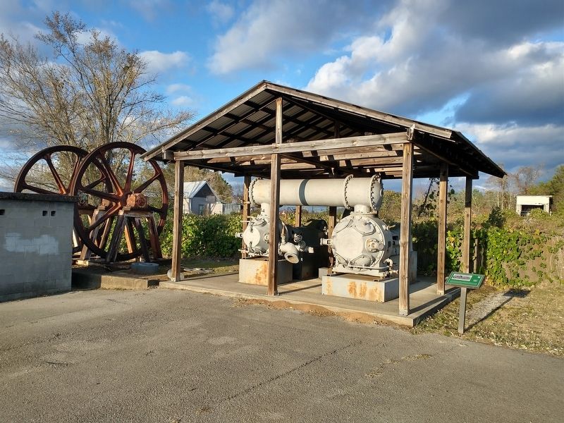
This 1921 Ingersoll Rand air compressor was purchased new in 1922 by the Ocoee Copper Company, which operated for a brief period in the Ducktown Basin. In 1927 it was purchased by the Ducktown Chemical & Iron Company (DC&I) and moved to Isabella, . . . — — Map (db m262069) HM
On Burra Burra Street, on the left when traveling east.
Baseball was a favorite, and serious, pastime in the mining towns of the Basin. In fact, for many years, Tennessee Copper Company fielded and sponsored a semi-pro team whose members were recruited primarily for their baseball ability. According to . . . — — Map (db m262553) HM
On Burra Burra Street, on the left when traveling east.
This building, constructed c. 1904 as a shed, was originally used to shelter the first ruck owned by the mine department. Later, as the fleet of vehicles grew, the company built garages at the top of the hill near the mine office. A floor was then . . . — — Map (db m262489) HM
On Burra Burra Street, on the left when traveling east.
This building, constructed in 1901, housed the boilers that produced the steam to power the equipment in the adjacent hoist house. It also supplied needed steam power to the other buildings on the site. In 1917, when the mining company began . . . — — Map (db m262550) HM
On Burra Burra Street, on the right when traveling south.
This is the bucket from one of the power shovels used in the mines to remove rock or ore that had been broken out during the process of blasting for headings. This was the process by which tunnels were created in the mines.
[Caption]: . . . — — Map (db m262049) HM
On Burra Burra Street, on the left when traveling south.
Visible to your left is a collapse into a small section of Burra Burra Mine. This section had been deliberately mined close to the surface because the grade of ore was so rich. After careful removal of the ore, the section was abandoned due to the . . . — — Map (db m262070) HM
On Burra Burra Street, on the left when traveling south.
This property was first mined by the Burra Burra Copper Company, which was formed in 1860 but went out of business soon after the Civil War. In 1899, Tennessee Copper Company (TCC) acquired the site and began work on the sinking of a new shaft at . . . — — Map (db m262105) HM
On Burra Burra Street at Muncher Street, on the left when traveling east on Burra Burra Street.
This building, constructed c. 1910, was originally used by the company doctor, who had previously been housed in the time office. In the mid-1910s, however, Tennessee Copper Company transferred all its medical services to its 20-room company . . . — — Map (db m262554) HM
On Muncher Street, on the right when traveling north.
The house visible across the highway from this point were originally constructed as workers’ homes for hourly employees. Although Tennessee Copper Company and its successors provided this kind of standard “mail-order” housing for some workers in . . . — — Map (db m262557) HM
On Burra Burra Street, on the right when traveling east.
These foundations, built in 1917, supported the cylindrical ore bins that stored the ore from Burra Burra Mine. The ore bins themselves stood some 40 feet above the foundations; trains pulling empty ore cars moved through the space underneath the . . . — — Map (db m262497) HM
On Burra Burra Street, on the left when traveling south.
This small building, which is partially visible on the far right of the photograph, housed the fire hose for the shop, change house, headframe and other structures located on the upper level of the Burra Burra site. The mine office (center) and the . . . — — Map (db m262106) HM
On Burra Burra Street, on the left when traveling east.
This structure housed the fire hose for the lower-level buildings. It also contained a connection to the company water system. The hose was stored inside, on a shelf.
[Caption]: Tennessee Copper Company firemen learning the use of new . . . — — Map (db m262495) HM
On Burra Burra Street, on the left when traveling south.
The mining company had its own firefighting gear and hydrants, which were sited at strategic points on the property. This block building replaced the earlier from structure, originally located s short distance away, that can be seen at the center of . . . — — Map (db m262067) HM
On Burra Burra Street, on the right when traveling south.
This large pot is a ladle from the Tennessee Copper Company smelter at Copperhill. The copper ore was smelted in large furnaces by heating it to temperatures just under 2000 degrees Fahrenheit. The molten copper was then separated from the other . . . — — Map (db m262048) HM
On Burra Burra Street, on the left when traveling south.
This piece of matte was recovered from the site of the 19th-century Burra Burra roast yards which extended for 14 acres. During the early days of mining, the raw copper ore was roasted in open sheds; each roast heap required 65 cords of wood, and . . . — — Map (db m262064) HM
On Burra Burra Street, on the right when traveling east.
From front to rear, these pieces of equipment from the local mines are a power shovel, a diesel mine locomotive, a compressed-air-powered engine, an ore car, and a second power shovel. Beside these items would have been the railroad tracks that . . . — — Map (db m262552) HM
On Burra Burra Street, on the left when traveling south.
The Burra Burra mine office was built around 1905, with additions in 1944 and 1967. The building served as surface headquarters for the mine and geology departments of Tennessee Copper Company and its successors; the geology staff worked in the . . . — — Map (db m262042) HM
On Burra Burra Street, on the right when traveling south.
The two homes visible beyond this sign were originally the homes of mining company officials. On the left is the home formerly allocated to the mine superintendent, who served as chief engineer in charge of the company’s entire mining department. On . . . — — Map (db m262103) HM
On Burra Burra Street, on the left when traveling east.
This building, which was constructed around 1905, stored the dynamite and blasting agents used in the mine at Burra Burra. The mine had an underground magazine that was used to store explosives, but it only held the amount needed for one week. The . . . — — Map (db m262491) HM
On Burra Burra Street, on the left when traveling south.
These sheave wheels from Tennessee Copper Company’s Calloway Mine sat at the top of the headframe and functioned as pulleys. The hoisting cables ran across the sheave wheels and then down into the mine via the shaft entrance. Both the sheave wheels . . . — — Map (db m262068) HM
On Burra Burra Street, on the left when traveling south.
This building, which was constructed in 1922, replaced an earlier frame structure that had stood in the same location. The building housed the carpenter, machine, blacksmith and drill repair shops, and mine equipment was fabricated or repaired here . . . — — Map (db m262107) HM
On Burra Burra Street, on the left when traveling south.
This is the sinking hoist used at Tennessee Copper Company’s Calloway Mine. During the sinking of a shaft, it was used to lower a bucket to lift out the rock broken from drilling and blasting. This process advanced the depth of the shaft in roughly . . . — — Map (db m262066) HM
On Burra Burra Street, on the left when traveling south.
The small rounded items are slag, the waste material from the blast furnaces. These examples, produced in the early 1900s by the smelters of the Ducktown Sulphur, Copper & Iron Company at Isabella, were purposely allowed to cool and harden in ladles . . . — — Map (db m262063) HM
On Burra Burra Street, on the left when traveling south.
Nineteenth-century copper smelters were constructed from local rock. Once the ore was heated to a melting temperature, the copper and iron separated and the iron settled into the bottom of the furnace, where it eventually re-solidified. These iron . . . — — Map (db m262065) HM
On Burra Burra Street, on the left when traveling east.
This building, constructed in 1901, housed the hoisting engines and a large air compressor. The hoisting engines were used for raising and lowering men and equipment into the mine, as well as for raising ore. The compressor supplied compressed air . . . — — Map (db m262499) HM
On Burra Burra Street, on the right when traveling east.
This building, constructed in 1902, originally housed the pay clerks and office staff along with the company doctor, whose office was located in the front room. In 1910, the doctor moved into the newly constructed clinic, and a few years later the . . . — — Map (db m262494) HM
On Burra Burra Street, on the right when traveling south.
This is a piece of unprocessed ore from the local mines. The ore in this region is a massive sulfide, which means that the copper iron and zinc found in the ore are in combination with sulfur. The most abundant of the sulfide minerals in the iron . . . — — Map (db m262045) HM
On Burra Burra Street, on the right when traveling east.
This walkway tunnel allowed workers to walk from the employee parking lot, which was beside the boiler house and hoist house, to the upper level of the mine site without having to cross the railroad tracks. It replaced a previous footpath that ran . . . — — Map (db m262555) HM
On Burra Burra Street, on the right when traveling south.
This drag, or winch, powered by compressed air, was used during the earlier years of the 20th century for moving ore and heavy equipment in the mines. It operated in a similar fashion to the later drag shown in the photograph, which ran on electric . . . — — Map (db m262046) HM