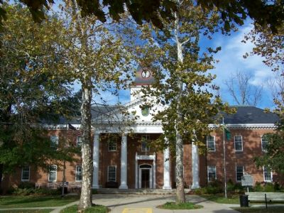
On Market Street near Between 1st and 2nd Streets, on the right when traveling west.
Caroline County-established, 1773, from parts of Queen Anne's and Dorchester Counties — held its early courts at seven different locations until 1797 when its first courthouse was built on this site, once known as Pig Point.
The 1895 . . . — — Map (db m3388) HM
On East Sunset Avenue (Maryland Route 314) west of Greensboro Road ( Route 313), on the left when traveling west.
Proud of their heritage along the banks of the Choptank River, the Town of Greensboro owns and manages Choptank River Park. The park served as the volunteer fire company's carnival grounds for many years until 2015, when after years of repeated . . . — — Map (db m205486) HM
On South 5th Avenue south of Legion Drive, on the right when traveling south.
A large brick structure that stood here for over two centuries had many historic uses.
Alms House (c. 1792-1826): County officials could commit a person to the "Poor House" with legal due process. The inmates had to work hard, sleep . . . — — Map (db m198805) HM
On Auction Road (Maryland Route 621) at Harmony Road ( Route 16), on the right when traveling east on Auction Road.
Born here on Wiltshire Manor in Caroline County in 1780. Moved to Foxley Hall, Easton on 1795. He read law under Judge Marshall. He met Andrew Jackson traveling across the Eastern Shore to the United States Congress. He moved to Nashville Tennessee. . . . — — Map (db m46119) HM
On Market Street at 2nd Street, on the right when traveling west on Market Street. Reported permanently removed.
Maryland slaves were not freed by the Emancipation Proclamation of 1863, which excluded states that remained in the Union from its provisions. It was Maryland's new constitution, adopted by the narrow margin of 291 votes of almost 60,000 cast on . . . — — Map (db m3389) HM
On Harmony Road (Maryland Route 16) at Wilkins Branch Road, on the left when traveling north on Harmony Road.
Member Maryland Assembly 1773–76. Introduced bill forming Caroline County 1774 of which he was one of the Commissioners. Colonel of the “Flying Camp” of the Eastern Shore 1776. Fought at Harlem Heights. First Colonel 5th Maryland Regiment. Moved . . . — — Map (db m107815) HM
On Market Street at North 2nd Street, on the right when traveling west on Market Street.
The 1863 Emancipation Proclamation did not free Maryland's enslaved people, as states that remained in the Union were excluded from the proclamation's provisions. It was Maryland's new constitution, adopted by the narrow margin of 291 votes out . . . — — Map (db m205446) HM
Near Detour Road east of Harmony Road ( Route 16), on the right when traveling east.
Once the Native American population was annihilated, dislocated, or marginalized by the public s well as private efforts, the type of crop grown had a great impact on the new residents of Edmondson's Reserve.
The first successful crop . . . — — Map (db m199272) HM
Near Detour Road 0.4 miles east of Harmony Road ( Route 16), on the right when traveling east.
The Caroline County 4-H Park, Delmarva Girl Scout Camp, and the farms bordering Detour Road are located on a former 1,050-acre tract of land that evidence indicates once served as a privately-owned Indian "reservation" called Edmondson's . . . — — Map (db m199271) HM
On River Landing Road 0.4 miles north of New Bridge Road ( Route 328), on the right when traveling north. Reported permanently removed.
On August 17, 1862, the steamboat Balloon arrived at Denton wharf and disembarked a company of New York infantry and a troop of cavalry. The soldiers quickly arrested twelve prominent local citizens and transported them to imprisonment at . . . — — Map (db m68428) HM
On James Madison Parkway (U.S. 301) at Roseland road, on the left when traveling north on James Madison Parkway.
John Wilkes Booth, the assassin of President Abraham Lincoln, and his accomplice David E. Herold, fled Washington, D.C. on April 14, 1865, for Southern Maryland, a hotbed of Confederate sympathizers skilled at evading Union surveillance. On April . . . — — Map (db m267329) HM
On Franklin Street (Maryland Route 404) at South 2nd Street, on the right when traveling east on Franklin Street.
Less than a block in both directions from this site, two young men from this small town grew up as Depression-era neighbors, competed in sports, later entered public service, and rose to the highest elective office in the neighboring states of . . . — — Map (db m137768) HM
On Crouse Park Lane west of Gay Street ( Route 404), on the right when traveling west.
The Denton wharf, here on the Choptank River, was the site of endless steamboat traffic, escapes of enslaved people on the Underground Railroad, and the arrests of active secessionists during the Civil War.
On August 17, 1862, the steamboat . . . — — Map (db m205463) HM
On 5th Street at South 6th Street, on the right when traveling north on 5th Street.
Originally called "Edenton" for Robert Eden, Maryland's last Colonial Governor.
Caroline County
was named in honor of his wife Caroline Calvert, a sister of Frederick, the last Lord Baltimore. — — Map (db m3391) HM
On North Charles Street at Hamilton Street on North Charles Street.
Contrary to Baltimore’s 19th century conservative appearance, Baltimoreans created progressive, diverse communities that expanded the nation’s racial and religious freedom. By the time of the Civil War, Baltimore had the largest free African . . . — — Map (db m102390) HM
On River Landing Road 0.4 miles north of New Bridge Road ( Route 328), on the right when traveling north. Reported damaged.
Steamboats carrying passengers and freight brought prosperity to Denton and Caroline County during the late 1800s and early 1900s.
Caroline County's economy was based on agriculture. Farmers had to market their products. Steamboats quickly . . . — — Map (db m68429) HM
On West Belle Street at North Maryland Avenue, on the right when traveling west on West Belle Street.
1867 - 1887
The railroad was completed to Ridgely in 1867. At that time there were two houses in the place — the Vernon property and the Ridgely Hotel. One of the factors getting the railroad to come. Mr. Thomas Bell had to give an area of . . . — — Map (db m205474) HM
On Cokesbury Road (State Highway 254), on the left when traveling east.
[Original Marker]
Site of Old Tabernacle Methodist Church. Buried here are Confederate Generals Martin Witherspoon Gary, Nathan George Evans and other Confederate officers and soldiers.
[Second Marker]
1000 feet east is . . . — — Map (db m11095) HM
Revolutionary War Patriot
Thomas Carney, a free African-American from Caroline County, served valiantly
in the Continental Army with the Maryland Line. A survivor of Valley Forge, he fought
in nine battles from Brandywine, PA to Eutaw Springs SC, . . . — — Map (db m226124) HM
Gilpin’s Point was one of the busiest wharves along the Choptank River in Caroline County where steamboats and sailing vessels transported people, timber, agricultural products, and seafood. It sat just upriver from Dr. Anthony C. Thompson’s . . . — — Map (db m79311) HM
On Crouse Park Lane west of Gay Street ( Route 404), on the right when traveling west.
With more free than enslaved blacks and a sympathetic Quaker population, Caroline County was a hotbed of Underground Railroad activity until slavery was abolished in Maryland in 1864.
Slaves, freemen of color, and whites often . . . — — Map (db m205449) HM
On High Street at Spring Street, on the right when traveling north on High Street.
The Call of Freedom
Dorchester County occupies a central place in the story of the Underground Railroad, the secret network of "stations" and "conductors" that sheltered and shepherded hundreds of enslave African Americans to freedom in the . . . — — Map (db m3964) HM
Near West Street (Maryland Route 450) at Brewer Avenue.
The record of lynchings in Maryland from 1891-1906
May 13, 1891 - Asbury Green, Centerville
May 17, 1892 - James Taylor, Chestertown
June 8, 1893 - Isaac Kemp, Princess Anne
October 20, 1894 - Stephen Williams, Prince George's County . . . — — Map (db m53171) HM
On North 2nd Street just south of Gay Street ( Route 404), on the right when traveling north.
Welcome to Caroline County! The Civil War intruded into quiet Eastern Shore communities, and residents of this beautiful, water-laced region faced difficult choices.
In the years before the war, enslaved African Americans from the Eastern . . . — — Map (db m205444) HM
Near Detour Road east of Harmony Road ( Route 16), on the right when traveling east.
often called the "Father of the Underground Railroad" (UGRR) and second in importance only to Harriet Tubman, William Still joined the UGRR in the late 1840s as a result of decisions made decades earlier by the owner of a tract of land in . . . — — Map (db m199281) HM
On Denton Road 0.2 miles north of Laurel Grove Road, on the left when traveling north.
Exeter
Exeter is one of the oldest remaining structures in the southern part of Caroline County. According to land records, the Reverend Thomas Dill (Dell) was granted a survey certificate and patent for 50 acres of land in Dorchester . . . — — Map (db m137763) HM
On Central Avenue (Maryland Route 312) at East Belle Street, on the right when traveling south on Central Avenue.
The Railroad was completed to Ridgely in 1867. The Saulsbury home was one of the earliest residences in Ridgely. Erected in 1867 by James K. Saulsbury, the building combined a large store where a widely known general merchandise business was . . . — — Map (db m205482) HM
Near Courtland Farm Road (Virginia Route 820) 0.2 miles east of Hanover Courthouse Road (U.S. 301), on the right when traveling east.
(side 1)
The Colonial River Road
After centuries of use by native people and the colonists of New Kent County, the road along the Pamunkey River was extended past the tobacco ports of Newcastle and Page’s Warehouse (later . . . — — Map (db m53801) HM
Thin black lines indicate changes in relevance. Between each pair of lines entries are ordered geographically but all have the same relevance.
* Inflectional forms of words are their plurals, singulars, and possessives as well as gramatical tenses and similar variations.