On County Road N 700 W north of County Road W 675 N, on the right when traveling north.
Front
The Wabash & Erie Canal meets the Wabash River
Carroll County Wabash & Erie Canal
Delphi, Indiana
See Photo #2:
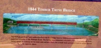
1844 Timber Truss Bridge
The Wabash and Erie Canal authorities built the first bridge here in . . . — — Map (db m35445) HM
On Tuscarawas Avenue (Ohio Route 211) at West Front Street, on the right when traveling south on Tuscarawas Avenue.
Christian Deardorff (1781-1851) with his brother-in-law Jesse Slingluff (1775-1836) platted and founded Dover and built the area's first gristmill on Sugar Creek. With the coming of the Ohio and Erie Canalto Dover, Deardorff lobbied successfully . . . — — Map (db m225416) HM
On Road N 700 W north of Road W 675 N, on the left when traveling north.
Front
The Longest Canal in North America
Carroll County Wabash & Erie Canal
Delphi, Indiana
The Wabash & Erie Canal extended 468 miles
from Toledo, Ohio to Evansville, Indiana
On March 2, 1827, a Congressional land grant made . . . — — Map (db m35449) HM
Constructed 1832-1853, canal was nation's longest, connecting Lake Erie at Toledo with Ohio River at Evansville. Key portion in Carroll County included Deer Creek Lake Dam, constructed 1838-1840 (1 mile west). Various canal structures are still in . . . — — Map (db m7540) HM
On Old Washington Road (Maryland Route 97) 0.2 miles south of Eden Mill Road, on the right when traveling south.
Near here the Confederate cavalry of Major General J.E.B. Stuart entered Carroll County from Cooksville about daybreak June 29, 1863. After damaging the tracks and bridge of the Baltimore and Ohio Railroad at Sykesville, they marched to Westminster . . . — — Map (db m268074) HM
On Indiana Route 29 near County Road 400, on the right when traveling south.
The sycamores here line the sides of the Michigan Road, which connected the Ohio River with Lake Michigan and further opened Indiana for white settlement and trade. Under intense military and economic pressure, Potawatomi leaders ceded the land for . . . — — Map (db m201388) HM
On North Main Street (Maryland Route 808) south of Prospect Road, on the right when traveling south.
On this site in front of you (where the caboose now stands) was once the original store and tavern established by Henry Bussard in 1837. The store served the local community on Parr's Ridge, and provided a rest stop for weary travelers upon the . . . — — Map (db m251981) HM
On Bicycle Bridge Road 0.1 miles west of West Monroe Street (Indiana Route 18), on the right when traveling east.
The Wabash & Erie Canal ran 468 miles from Toledo, Ohio to Evansville, Indiana, thus providing
access to New York and the East Coast via the Erie Canal and access to New Orleans and the Gulf of
Mexico via the Ohio and Mississippi Rivers.
. . . — — Map (db m163354) HM
Near West North Washington Street at North Charles Street, on the right when traveling east.
The Wabash & Erie Canal ran 468 miles from Toledo, Ohio to Evansville, Indiana, thus providing
access to New York and the East Coast via the Erie Canal and access to New Orleans and the Gulf of
Mexico via the Ohio and Mississippi . . . — — Map (db m163281) HM
On Old Camden Road at East Main Street, on the right when traveling north on Old Camden Road.
The Wabash & Erie Canal ran 468 miles from Toledo, Ohio to Evansville, Indiana, thus providing access to New York and the East Coast via the Erie Canal and access to New Orleans and the Gulf of Mexico via the Ohio and Mississippi Rivers. . . . — — Map (db m312634) HM
On Hoosier Heartland Highway (Indiana Route 25) at East Main Street, on the right when traveling north on Hoosier Heartland Highway.
The Wabash & Erie Canal ran 468 miles from Toledo, Ohio to Evansville, Indiana, thus providing access to New York and the East Coast via the Erie Canal and access to New Orleans and the Gulf of Mexico via the Ohio and Mississippi Rivers. . . . — — Map (db m312651) HM
On West 18th Street at Baynard Boulevard on West 18th Street.
African American Medal of Honor Recipients Memorial
The Medal of Honor takes its place in our country as the highest award for military valor. The honor, awarded by the President in the name of Congress, may only be accorded an . . . — — Map (db m173924) HM WM
On Newnan Street (Georgia Route 166) at Dixie Street, on the right when traveling east on Newnan Street.
Carroll County, created by an act of the Georgia legislature in December, 1826, proudly bears the name of Charles Carroll, of Carrollton.
Charles Carroll was born in Annapolis, Maryland, in 1737. He attended preparatory schools in this country . . . — — Map (db m12872) HM
On Buttercup Road south of Raincliffe Road, on the left when traveling south.
Around 1750, the community of Eldersburg was founded by John Elder, who was given a land grant from the King of England for as much land as Elder could stake out in 24 hours. John Elder staked an 800-acre farm named Perseverance on a stagecoach . . . — — Map (db m134037) HM
On West High Street at Main Cross Street, on the right when traveling west on West High Street.
is a contributing property to the
Warsaw Historic District
listed in the
National Register
of Historic Places
by the United States
Department of the Interior — — Map (db m222961) HM
On West Main Street (Maryland Route 851) at Baldwin Drive, on the right when traveling west on West Main Street. Reported missing.
In June 1863, as Gen. Robert E. Lee and the Army of Northern Virginia marched north, Gen. J.E.B. Stuart’s Confederate cavalry rode east of the main army. Soon, Federal cavalry hunted Stuart. Before dawn on June 29, several former area residents . . . — — Map (db m13883) HM
On West Main Street at Baldwin Drive, on the right when traveling west on West Main Street.
In late June 1863, Gen. J.E.B. Stuart's Confederate cavalry pounded through this area on a raid while, to the west, Gen. Robert E. Lee and the main body of the Army of Northern Virginia marched northward. Before dawn on June 29, several former area . . . — — Map (db m252269) HM
On South Center Street at Farm Museum Drive, on the right when traveling south on South Center Street.
The Carroll County Barn Quilt Trail honors Carroll County's agrarian culture by bringing together historic barns and a "sampler" of quilt block patterns. These quilt blocks include both classic patterns that depict life in a rural society as well . . . — — Map (db m188399) HM
On Market Street west of North 3rd Street, on the right when traveling west.
This cannon stands as a rare survivor of Ohio's early military history. Believed to have been forged in Steubenville in the mid-1820s under the direction of General Samuel Stokely for local militia service, this cannon is one of the few remaining . . . — — Map (db m307550) HM
Near Tennessee Route 22 0.6 miles north of Interstate 40, on the right when traveling north.
This area was named for the Parker farm whose residence was located just south of here. John M. Parker, both a practicing physician and a Baptist preacher, was known as both Doctor and Reverend Parker. His farm straddled the intersection of . . . — — Map (db m72241) HM
On Bicycle Bridge Road 0.1 miles west of West Monroe Street (Indiana Route 18), on the right when traveling east.
Great Place to Visit
Enjoy yourself, take your time, bring your camera and
your fishing tackle, watch the clouds reflected on the
Wabash, experience the spirit of a nineteenth century
downtown square, walk a tree lined trail along the . . . — — Map (db m163356) HM
Near West North Washington Street just east of North Charles Street, on the right when traveling east.
Carroll County Wabash & Erie Canal, Inc.
Founded in 1974, in Delphi, Indiana, Carroll County Wabash & Erie Canal, Inc. is dedicated to the
preservation of the stretch of the Wabash & Erie Canal located in Delphi, Indiana. Approximately . . . — — Map (db m163280) HM
On Bicycle Bridge Road 0.1 miles west of West Monroe Street (Indiana Route 18), on the right when traveling east.
Carroll County Wabash & Erie Canal, Inc.
Founded in 1974, in Delphi, Indiana, Carroll County Wabash & Erie Canal, Inc. is dedicated to the
preservation of the stretch of the Wabash & Erie Canal located in Delphi, Indiana. Approximately . . . — — Map (db m163355) HM
Near West North Washington Street at North Charles Street, on the right when traveling east.
Great Place to Visit
Enjoy yourself, take your time, bring your camera and
your fishing tackle, watch the clouds reflected on the
Wabash, experience the spirit of a nineteenth century
downtown square, walk a tree lined trail along the . . . — — Map (db m163306) HM
Thin black lines indicate changes in relevance. Between each pair of lines entries are ordered geographically but all have the same relevance.
* Inflectional forms of words are their plurals, singulars, and possessives as well as gramatical tenses and similar variations.