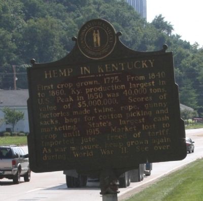
On U.S. 127 south of Frazer Road, on the right when traveling south.
Side A Kentucky River Mills began making hemp yarns for backs of Brussels carpets in 1878, and started producing binder twine in 1879. Finest quality imported machinery used. Employed 125 persons year round. In 1941, received contract from . . . — — Map (db m22152) HM
On East Main Street (U.S. 60) east of Atwood Avenue, on the right when traveling east.
The African American Civil War Memorial in Greenhill Cemetery is only monument in state honoring the nearly 25,000 Kentuckians who served in the United States Colored Troops. The names of 142 men from central Ky are etched on monument. Memorial . . . — — Map (db m161756) HM
On Wilkinson Boulevard, on the right when traveling south.
Between 1776 and 1780 Kentucky was a single county of the
commonwealth of Virginia. In 1780 the Virginia legislature divided
Kentucky County into three smaller counties–Fayette, Jefferson
and Lincoln. These became Kentucky's first three counties . . . — — Map (db m194233) HM
On St. Clair Street south of Wapping Street, on the left when traveling south.
Frankfort Bridge Site In 1810, the Frankfort Bridge Company was chartered to erect a bridge at this site. The bridge was completed here in 1816 at a cost of $25,000.00. In July, 1834 the bridge collapsed. A replacement bridge collapsed in . . . — — Map (db m84879) HM
On Green Hill Cemetery Road 0.1 miles east of Atwood Avenue, on the right when traveling north.
Officially, 23,703 African Americans in Kentucky responded to the call to arms by President Lincoln and Frederick Douglass to join the ranks of the newly organized United States Colored Troops. Units were organized with men from across the . . . — — Map (db m84675) HM
On West Front Street east of Lafayette Street, on the right when traveling east.
Kentucky natives William G. and Lucinda Owens came to Missouri in 1818. William soon became the leading politician of newly created Franklin County. In 1827 he purchased a farm and ferry boat at Washington Landing. On July 4, 1829, he began to sell . . . — — Map (db m124370) HM
On Dubose Street (Tennessee Route 56) north of Dixie Lee Avenue (U.S. 64), on the right when traveling north.
Monteagle is an important crossroads in the southern Cumberland Mountains, where roads and railroads crisscross rugged, scenic terrain. In the summer of 1862, Union and Confederate forces raced for advantage among these transportation corridors. . . . — — Map (db m167629) HM
On Wilkinson Boulevard, on the right when traveling south.
Look across the river toward
Benson Creek and you will see
two bridges. Both are steel span
bridges, and both share one
common aspect - they are
supported by dry-laid
abutments.
Many bridges across Kentucky,
including covered bridges . . . — — Map (db m194222) HM
On West Main Street at Catfish Alley, on the right when traveling west on West Main Street.
After a disastrous fire in 1999 this historic house was
preserved by the Kentucky Trust for Historic Preservation.
William Owsley bought the house in 1835 and lived here
when elected Governor in 1844. The house was built in 1813
by William . . . — — Map (db m194243) HM
On Mero Street (Kentucky Route 420) just east of Wilkinson Boulevard (U.S. 421), on the right when traveling west.
Erected in 1928 and dedicated September 3,
1929, Mayo-Underwood High School replaced
the 1884 Clinton Street High School. Mayo-
Underwoods main entrance faced Center
Street, with the Mero Street side encompassing
the 400 block, and the rear . . . — — Map (db m194238) HM
On Wilkinson Boulevard, on the right when traveling south.
Opened in 1997, Kentucky River View park was a cooperative project of the
Kentucky River Authority, the Kentucky Economic Development Cabinet, the
City of Frankfort, Franklin County Fiscal Court, the Kentucky Transportation
Cabinet, the Kentucky . . . — — Map (db m194235) HM
Near Louisville Road (U.S. 60) 0.3 miles north of Lafayette Drive, on the right when traveling east.
(panel A)
Welcome
to
Kentucky's Capitol
The Kentucky Capitol Building
and
Capital
Frankfort - Kentucky's Capital City
(panel B)
Welcome to Kentucky's Capitol
Construction of the Capitol began in . . . — — Map (db m62274) HM
On Wilkinson Blvd south of Frazer Road, on the right when traveling south.
Willis A. Lee, Jr., built a double two-story log house here in 1793. Tract of land on which the house stood was given to Lee by his uncle, Hancock Lee, founder of Leestown, the first settlement in Franklin County. In 1815 Lee erected a story and a . . . — — Map (db m22126) HM
On Green Hill Cemetery Road 0.1 miles east of Atwood Avenue, on the right when traveling north.
(North face) Erected by Woman's Relief Corps No. 8 G.A.R. July 1924 Monument Commission E.T. Strauss, President N.C. Coleman, Secretary L.C. Redding Mary L. Brooks Clara C. McWilliams Susan Butcher M.B. McCary Sallie Handy Kate Richardson . . . — — Map (db m84704) WM
Near Beulah Way at Columbus Street, on the right when traveling east.
The origin of Beulah Park Race Track began in 1889 when local businessman A. G. Grant petitioned the village of Grove City to create the Beulah Addition housing development on farmland once owned by town founder William Foster Breck. Grant named . . . — — Map (db m225782) HM
Lulu Colyar Reese was a socially prominent clubwoman who became active in Memphis education and politics as an advocate for free textbooks and child labor laws. In 1916, she was one of the first two women elected to the Memphis City Board of . . . — — Map (db m204266) HM
Near Alabama Route 33 0.2 miles south of County Route 67, on the left when traveling south.
Discover the Incredible Variety of Habitats and Birds in the Bankhead National Forest
1. Walston Ridge Road
The road along Walston Ridge provides a variety of forest habitats. Prescribed fire maintains the open oak-pine woodlands. . . . — — Map (db m107294) HM
On West Main Street east of Washington Street, on the right when traveling east.
In 1799, John Goodman manufactured furniture on Cross Street in
Lexington. By 1801, he had moved his furniture factory to Frankfort,
where, in this house he produced the first Kentucky-made piano. He
made it for the daughter of Governor James . . . — — Map (db m194242) HM
Old Auxvasse Presbyterian is one of the oldest congregations west of the Mississippi. But this hill on which the congregation first met in 1828 in a log church earlier hosted travelers along the Trial, some of whom likely were buried here before . . . — — Map (db m216974) HM
On Wilkinson Boulevard, on the right when traveling south.
Edge fences are so named
because the rocks are placed on
their edges instead of being laid
horizontally.
They are primarily built using
field-collected rocks. The edge
fence in the park has a drain
covered by a flat rock called . . . — — Map (db m194227) HM
Frontier Nashville
European exploration of the Middle
Tennessee region began as early as the 16th
century with the expedition of Spaniard
Hernando de Soto. By the early 18th
century French traders were exchanging
furs with the area's . . . — — Map (db m207197) HM
Thin black lines indicate changes in relevance. Between each pair of lines entries are ordered geographically but all have the same relevance.
* Inflectional forms of words are their plurals, singulars, and possessives as well as gramatical tenses and similar variations.