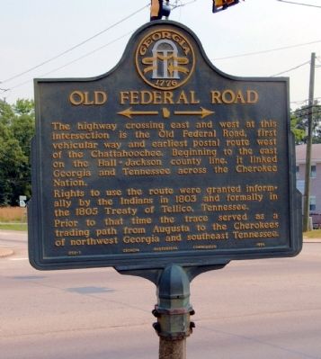
On Dahlonega Highway (Georgia Route 9) at Browns Bridge Road ( Route 369), on the left when traveling north on Dahlonega Highway.
The highway crossing east and west at this intersection is the Old Federal Road, first vehicular way and earliest postal route west of the Chattahoochee. Beginning to the east on the Hall-Jackson county line, it linked Georgia and Tennessee across . . . — — Map (db m21287) HM
Side A One of the Five Lower Towns established by the Chickamauga Cherokees in 1782 under the leadership of Dragging Canoe. Territorial Governor William Blount reported to the Secretary of War in 1792 that: “Crow Town lies on the north . . . — — Map (db m28473) HM
On Riverfront Parkway, on the left when traveling east.
In May 1838 soldiers, under the command of Gen. Winfield Scott, began rounding up Cherokee Indians in this area who had refused to move to Indian Territory (Oklahoma). About 15,000 Cherokees were placed in stockades in Tennessee and Alabama until . . . — — Map (db m81675) HM
On Greenland Drive at North University Street, on the right when traveling west on Greenland Drive.
The Confederate Circle at historic Evergreen Cemetery was established in 1890. The reburial of Confederate dead from across the county here took place the following year.
Among those buried here is Robert James Campbell Gailbreath . . . — — Map (db m69176) HM
On Ferbee Road east of Garners Creek Road, on the right when traveling east.
In 1864, just to your left, the Federal army established Camp Gillem to protect the locomotive yard here at Gillem Station. Both were named for Gen. Alvan C. Gillem, commander of the troops guarding and constructing the Nashville and Northwestern . . . — — Map (db m203665) HM
On Main Street (State Highway 56) at Hillcrest Drive, on the right when traveling south on Main Street.
Red Boiling Springs has long been a landmark in Macon County. It was a central crossroads for both Federal and Confederate forces during the Civil War.
The war came home for local residents on September 24, 1861, when Capts. Ridley R. West and . . . — — Map (db m39584) HM
On South Scott Street north of East Charlotte Avenue, on the left when traveling north.
Robert E. Jones, Jr.
In 1946, Robert E. Jones, Jr. was elected to serve in the U.S. House of Representatives to fill Alabama’s 5th Congressional District seat vacated by John J. Sparkman’s election to the U.S. Senate. Elected to 15 . . . — — Map (db m100042) HM
On Walnut Street (U.S. 90), on the right when traveling east.
William L. Menefee, born ca. 1796 in Knox County, Tennessee, served in the Tennessee Militia in the War of 1812. He studied law and was admitted to the bar sometime prior to 1824 when he moved to Alabama. In 1830 he and his wife Agnes (Sutherland) . . . — — Map (db m130391) HM
On Old Highway 431 north of Cherry Tree Rd (County Road 28), on the left when traveling south.
Approximately 150 yards north is the grave site of Williamson Robert Winfield Cobb, U.S. and Confederate Congressman. Cobb was born in 1807 in Rhea County, Tennessee. In 1809, his family moved to southeastern Madison County, Alabama, where he . . . — — Map (db m289641) HM
Butler's Landing Daniel Boone, on his trip to the Western Territory in 1773, followed the old game and Indian trail to where two creeks flowed into the Cumberland River. He referred to them as the Twin or Double Creeks in his journal. On this . . . — — Map (db m74336) HM WM
On East Main Street (Tennessee Route 151), on the left when traveling east.
Named by early pioneers traversing thru the region, this designated Indian trail led these settlers into this area during Western migration. This mainly Cherokee trail, (although used some by the Shawnee), originated at Rockwood in Roane County, . . . — — Map (db m180021) HM
On South Jackson Street (U.S. 41A) at West Volney Street, on the right when traveling south on South Jackson Street.
No sooner did the North begin its invasion than slaves fled to Union lines seeking freedom. This presented problems for military commanders and President Lincoln. The political aims of the war did not initially include emancipation. Before Lincoln’s . . . — — Map (db m75324) HM
On Atlanta Highway (Georgia Route 13) at Radford Road on Atlanta Highway.
The route leading west from this point is the Old Federal Road, an early thoroughfare which linked Georgia and Tennessee across the Cherokee Nation. Rights to open the passage were granted informally by the Indians in 1803 and confirmed by treaty in . . . — — Map (db m24718) HM
On West Main Street (Business U.S. 59), on the right when traveling east.
Home of the Karankawa Indians granted in part to Stephen F. Austin and to Martin de Leon. Settled 1824-1835 by colonists largely from Alabama, Louisiana, Kentucky, Tennessee and, west of the Lavaca, Mexico. Organized as a municipality December 5, . . . — — Map (db m120609) HM
On County Road 90 0.1 miles east of Alabama Route 73, on the right when traveling east.
Ebenezer Baptist Church is the oldest church on the northern end of Sand Mountain. Its origins date back to an 1850s log church and school called Gordon Chapel. Renamed Ebenezer, the church became a member of the Tennessee River Baptist Association . . . — — Map (db m156122) HM
On County Route 21 1 mile east of Alabama Route 79, on the right when traveling east.
This critical five-mile road connected Cumberland Mountain to the river valleys of the Paint Rock and the Tennessee. A feat of engineering and determination, its construction was part of a New Deal-era project to aid Jackson County residents left . . . — — Map (db m274334) HM
On South Logan Avenue south of East Main Street (Illinois Route 13), on the right when traveling north.
The first memorial service in Illinois, and one of the first in the nation, to honor those who had died in the Civil War, took place at Woodlawn Cemetery on April 29, 1866. On that day, a group of more than 200 veterans gathered at the old "Blue . . . — — Map (db m163493) HM
Near Missouri Route 5 at Katy Trail, on the right when traveling south.
Josiah Gregg was born in Overton County, Tennessee – the youngest son of Harmon and Susannah (Smelser) Greggs' seven children. In 1812 his family settled at Cooper's Fort in Howard County, and later moved to Jackson County. Sickly, shy and studious, . . . — — Map (db m252443) HM
On W. Houston St. at N. Flores St., on the right when traveling west on W. Houston St..
(monument text) (1833-1903) Educator Attorney Public Servant Soldier Merchant Banker (plaque text): Thomas Claiborne Frost (1833 – 1903)
Born in Jackson County, Alabama in 1833, T. C. Frost graduated from Irving College . . . — — Map (db m63694) HM WM
Brief Background: After Abraham Lincoln, who was against slavery, became President in 1860, eleven southern states seceded and formed the Confederate States of America. In 1861, after a decade of simmering tension between the northern and . . . — — Map (db m268154) HM WM
Near 4th Avenue S. at Oak Street. Reported permanently removed.
1794-1835
Jackson County attorney;
aide-de-camp, General Carroll,
at New Orleans, 1815;
State Senator, 1827-29;
Bank Commissioner, 1829;
Secretary of State
for Tennessee, 1831-35.
His motto: Office has no
charms to . . . — — Map (db m214916) HM
On South Main Street (Farm to Market Road 2268) at College Hill Drive, on the right when traveling north on South Main Street.
Mary Elizabeth "Liz" Sutherland Carpenter was a nationally known White House official, writer, and speaker. Her choice of Salado College Hill, where her parents met, for the scattering of her ashes completed full circle her remarkable life journey. . . . — — Map (db m212454) HM
On Avenue Street west of Dillard Street, on the right when traveling west.
[South face] The Jackson Guards were organized at Jacksonport, Jackson County, Arkansas, by Capt. A. B. Pickett, a prominent lawyer of Jacksonport, Sunday morning, May 5, 1861. The company was marched to the Presbyterian Church and there . . . — — Map (db m221231) HM WM
On Iberville Drive east of Ames Avenue, on the left when traveling east.
Marble Springs Park History
Sawmill Operators, James Lynch and Reverend P.P. Bowen (Tidewater Baptist Church) first discovered the mineral springs on the south bank of Old Fort Bayou in 1852 after noticing a small stream which left some . . . — — Map (db m290182) HM
Near SW Front Street south of West Elm Street, on the right.
Carl Perkins delivered what many consider
the first big hit of rock 'n' roll music.
His "Blue Suede Shoes" in 1956 shot
to number one across a broad range of
music charts and became the first million-
selling single for Sun Records.
Perkins . . . — — Map (db m170395) HM
On North Grundy Highway north of Dodson Branch Highway, on the left when traveling north.
North of this marker lies the site of Old Columbus,
once an important landing on the Cumberland
River. In the winter of 1863–1864, the war
had disastrous consequences for this river village.
Late in December 1863, Gen. Ulysses . . . — — Map (db m68344) HM
Thin black lines indicate changes in relevance. Between each pair of lines entries are ordered geographically but all have the same relevance.
* Inflectional forms of words are their plurals, singulars, and possessives as well as gramatical tenses and similar variations.