On North Panna Maria Avenue (Business State Highway 123) at West Calvert Avenue (Business U.S. 181), on the right on North Panna Maria Avenue.
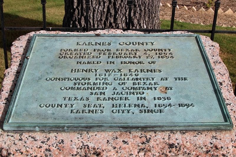
Formed from Bexar County
Created February 4, 1854
Organized February 27, 1854
Named in honor of
Henry Wax Karnes
1812-1840
Conspicuous for gallantry at
storming of Bexar
Commanded a company at
San Jacinto
Texas Ranger . . . — — Map (db m121656) HM
On Farm to Market Road 102 south of Farm to Market Road 263, on the right when traveling south.
Joseph (c. 1787-1831) and Rachel Rabb (1790-1872) Newman were married in 1806 in Ohio. Following Joseph's service in the War of 1812 in Illinois, they lived in Arkansas Territory on the Red River before moving into Texas in 1820. In 1823, they left . . . — — Map (db m96300) HM
Named by the Spaniards about 1800 because of its midway position between the San Antonio and Nueces Rivers. Rises in Karnes County; empties into Mission River. Crossed by explorers, padres, soldiers, settlers who traveled on three early ox-cart . . . — — Map (db m202009) HM
On County Road 262 at Farm to Market Road 627, on the right when traveling north on County Road 262.
According to oral tradition, the Harmony Baptist Church began in 1864. A church building was constructed by 1875, when Thomas Ragsdale donated land at this site to the church. The building was used also for school classes and Woodmen of the World . . . — — Map (db m235017) HM
Near Farm to Market Road 81 south of County Road 302.
Soon after Karnes County was created and organized in 1854, a frame and clapboard courthouse was erected at this site in the center of Jefferson Square.
This rock structure was built in 1873 to replace the first courthouse and adjacent county . . . — — Map (db m132370) HM
On Farm to Market Road 1681 at County Highway 438, on the right when traveling east on Highway 1681.
The community of Nockenut began in 1857, when a number of German and Polish immigrants settled in this area. Originally located in Guadalupe County, it became part of Wilson County after a boundary change in 1869. A post office opened in 1858, and . . . — — Map (db m207564) HM
On Farm to Market Road 887 0.2 miles south of Loop State Highway 190, on the right when traveling south.
250 yards west lie the remains of a pioneer dam built in 1869 by Carl Edward Riedel to supply the power for his sawmill, gristmill and cotton gin.
That year another German immigrant, Max Krueger, helped install Riedel's gin - first steam cotton . . . — — Map (db m235012) HM
On East Calvert (Business U.S. 181) at South Esplanade Street, on the right when traveling east on East Calvert.
Seat of Karnes County; was founded in Christmas season, 1890, when a partnership headed by Otto Buchel bought 1,000 acres of land from J. L. Calvert for $5 an acre. The tract was near the geographic center of the county and adjoined the . . . — — Map (db m131922) HM
On North Panna Maria Avenue (Business State Highway 123) at West Calvert Avenue (Business U.S. 181), on the right when traveling south on North Panna Maria Avenue.
In 1854 Karnes County erected its first courthouse in the county seat of Helena, an important stage stop between San Antonio and Goliad. The original courthouse was destroyed in a storm about 1865 and a new stone courthouse was built in Helena in . . . — — Map (db m292027) HM
On Church Street at Farm to Market Road 444, on the right when traveling east on Church Street.
A group of Polish immigrants from Upper Silesia (Prussian-occupied Poland) moved to this area in 1858, after a brief settlement in Karnes County. Here the prairies could be plowed and oaks could be felled for building shelter. They called their . . . — — Map (db m192538) HM
On Peach Street west of Goliad Road, on the right when traveling west.
In 1731, the Spanish government relocated Mission San José de Los Nazonis, founded in east Texas, to a new site on the east bank of the San Antonio River. They renamed the mission San Juan Capistrano. There, Franciscan missionaries from the . . . — — Map (db m305370) HM
On Farm to Market Road 81 south of County Road 302, on the right when traveling north.
Founding father of Karnes County, Ruckman was born in Northumberland County, Pennsylvania. He graduated in 1848 from the College of New Jersey (now Princeton University) and taught in South Carolina for a year. But the lure of Texas - then a . . . — — Map (db m132372) HM
On Helena Street (Farm to Market Road 81) at West Guadalupe Street, on the right when traveling south on Helena Street.
Early Texas town. Near site where old ox-cart road from San Antonio to Indianola crossed the Ojo de Agua (Spanish name meaning "Eye of Water" or Spring) Creek. Here pioneer travelers found essentials of water, wood, and grass. Numerous Indian . . . — — Map (db m174609) HM
On 3rd Street north of D Street, on the right when traveling north.
The Flores de Abrego family came to the New World from northern Spain before the time of the American Revolution. During the 18th century, members of this family brought their cattle northward and established ranches along the San Antonio River. . . . — — Map (db m118697) HM
Thin black lines indicate changes in relevance. Between each pair of lines entries are ordered geographically but all have the same relevance.
* Inflectional forms of words are their plurals, singulars, and possessives as well as gramatical tenses and similar variations.