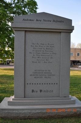
On Court Street (County Route 460) east of Market Street (Alabama Route 33), on the right when traveling east.
(front)
Dedicated to the men of Lawrence County, Alabama,
from all walks of life, who left kith and kin,
hearth and home, and lost their lives in military service
for the Confederate States of America during
the War for Southern . . . — — Map (db m84311) WM
On County Road 23 at County Road 26, on the right when traveling north on County Road 23.
In 1843, David Hubbard (1792-1874), residing on a 120 acre tract in this section, was overseeing the construction of his mills and factories. A War of 1812 veteran and cousin to Sam Houston, David was the son of Revolutionary War officer Thomas . . . — — Map (db m262633) HM
On Gordon Drive Southeast at 8th Avenue Southeast, on the right when traveling east on Gordon Drive Southeast.
Born in 1894 in Normandy, Tennessee, Carolyn Cortner was raised in the Courtland area of Lawrence County, Alabama. She attended Ward-Belmont College in Tennessee. She married Wilburn Smith in 1912. She did not attend formal architecture school . . . — — Map (db m27814) HM
On Main Street at 1st Street, on the left when traveling south on Main Street.
Frank R. King was born in Leighton on October 30, 1859, the son of Hartwell Richard and Mary Henderson (Smith) King. He grew up on a farm and attended common schools in Leighton and Trinity. King attended the University of Alabama from 1875 to 1876. . . . — — Map (db m236488) HM
On Cooperage Way (County Route 700) at Alabama Route 20, on the right when traveling south on Cooperage Way.
(side 1)
This small dwelling is the last reminder of "Boxwood" plantation, the home of the Elliot family, and later of the Nevilles. Built-in 1854 of slave-made brick and occupied by the household servants it is one of the few brick . . . — — Map (db m114719) HM
On Jessie Jackson Parkway 0.5 miles south of Alabama Highway 20, on the right when traveling south.
The African American community of Courtland, led by Principal Richard A. Hubbard, bought this land to establish a public school for its students in a segregated South. Prior to this, Black students gathered in various locations as part of the . . . — — Map (db m302013) HM
On Wheeler Dam Highway (Alabama Route 101) 0.5 miles south of County Route 584, on the left when traveling south.
Wheeler Dam
Wheeler Dam is located south of here on the Tennessee River, between Lauderdale County on the north and Lawrence County on the south. It is located 275 miles above the mouth of the Tennessee River at Paducah, Ky. on the Ohio River. . . . — — Map (db m105132) HM
Side A Federal lands in this area were first sold in 1818 and quickly purchased by settlers and speculators. A group of investors calling themselves the “Courtland Land Company” and consisting of William H. Whitaker, James M. . . . — — Map (db m28989) HM
On Market Street (Alabama Route 33) at Walnut Street when traveling south on Market Street.
Born on this site about 1820 to Phillip and Sarah Roddy, Phillip Dale Roddy grew up in poverty. His father a saddle maker and War of 1812 veteran, was one of the earliest murder victims in Moulton. Phillip Dale was raised by his mother and received . . . — — Map (db m69674) HM
On County Route 334 north of County Road 87, on the right when traveling north.
McDaniel Cemetery #1
This cemetery is one of the oldest in the county. In the 1980s, the cemetery had all but disappeared except for four headstones and cemetery rocks found stacked under a tree. In March 2021, Marisa McDaniel Keenum oversaw . . . — — Map (db m286618) HM
On Main Street at South Street, on the right when traveling south on Main Street.
Moulton Church of Christ is one of the oldest congregations of the Churches of Christ in Alabama. It was born of the Restoration Movement which sought to restore the Christian Church to its biblical roots. The movement began in both Europe and . . . — — Map (db m201353) HM
Born near this site 12 September 1913 to Henry Cleveland and Emma (Fitzgerald) Owens, who were sharecroppers and the offspring of freed slaves, Jesse was destined to attain immortality in the 1936 Olympic Games at Berlin, Germany. Although he moved . . . — — Map (db m80969) HM
On County Line Road (Alabama Route 99) 0.2 miles north of Bethel Cemetery Road, on the left when traveling north.
The church was organized as Bethel Missionary Baptist Church on June 26, 1819, with Elder Theophilous Skinner serving as pastor. The church predates the creation of the state of Alabama by nearly 6 months. Bethel’s original was across County Line . . . — — Map (db m213754) HM
Wyatt Cheatham (1769-1856) was one of the early settlers of Lawrence County and bought land near Wren in 1818. The Alabama Legislature on 14 Dec 1824 authorized him, "to open out and make a road leading from at or near the Gum Pond in said county . . . — — Map (db m84310) HM
On Old Highway 20 at County Line Rd, on the left when traveling south on Old Highway 20.
Crossroads, or Jeffers Crossroads, now known as Leighton, marked the end of the segment of the Byler Road that was finished by early 1820. Here, the Byler intersected with the Decatur to Tuscumbia/Courtland Stage Road. For a time, Byler Road passed . . . — — Map (db m314933) HM
On Jefferson Street at Van Buren Street, on the right when traveling west on Jefferson Street.
Built about 1830 for merchant Joseph Trotter, this house was purchased in 1838 by John J. McMahon, a Virginia-born cotton factor who divided his time between Courtland and New Orleans. The house remained the home of McMahon's descendants for nearly . . . — — Map (db m84307) HM
On Musket Lane, on the right when traveling south.
• Raised in frontier poverty without any education until he is a teenager, David is often hired out to others for additional income while still a child; once held against his will until he escapes under the cover of a winter storm. • To avoid . . . — — Map (db m58421) HM
On North 6th Street at Washington Ave, on the right when traveling north on North 6th Street.
Following the American Civil War and Emancipation of slaves in 1865, it was not until 1867 that African Americans in Texas were able to uniformly register to vote, following the ratification of the 15th Amendment to the U.S. Constitution. . . . — — Map (db m300108) HM
On U.S. 62/67 north of South Bettis Street, on the right when traveling north.
People have hunted and fished in the rich Black River Basin at least since the Paleo Indian Period (beginning around 10,000 B.C.). More recently, Native American built villages and mounds across the Mississippi River valley (3000 B.C.-A.D.1650). . . . — — Map (db m170367) HM
On North College Street at East Main Street (MLK Jr. Blvd), on the right when traveling north on North College Street.
Emory W. Rogers was born in Lawrence County, Alabama on July 2, 1813. Nancy Clinton was born on October 28, 1810. The Couple Married in 1833.
Mr. Rogers obtained a "Headright" certificate from the Republic of Texas in 1839, for 640 acres of . . . — — Map (db m212735) HM
On Alabama Route 69 0.1 miles west of County Road 747, on the left when traveling east.
The Cullman County Electric Membership Corporation
the first rural electric cooperative in Alabama to provide
electricity. The cooperative, was organized May 25. 1936,
under an executive order signed by President Franklin D.
Roosevelt. Near . . . — — Map (db m295689) HM
On County Road 23 at County Road 32, on the right when traveling south on County Road 23.
On April 27, 2011 the lives and the landscape of
the community of Mt. Hope was forever changed.
During its 132 mile path of destruction, an EF5
tornado that was approximately 1 mile wide and with
winds in excess of 200mph passed through our . . . — — Map (db m309430) HM
On Stadium Street near East College Street (U.S. 64).
Bell's Route of the Cherokee Trail of Tears in Tennessee, Arkansas, and Oklahoma, 1838-1839 Overview
The detachment headed by John Bell differed from the parties under Cherokee Chief John Ross's supervision. Bell's detachment was composed of . . . — — Map (db m29811) HM
“Be always sure you are right, then go ahead!”
• Raised in frontier poverty without any education until he is a teenager, David is often hired out to others for additional income while still a child; once held against his will until . . . — — Map (db m108201) HM
Thin black lines indicate changes in relevance. Between each pair of lines entries are ordered geographically but all have the same relevance.
* Inflectional forms of words are their plurals, singulars, and possessives as well as gramatical tenses and similar variations.