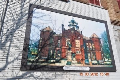
On Waterloo Street at Public Square, on the right when traveling west on Waterloo Street.
Cornerstone placed June 19, 1905 by Mimosa Lodge No. 542 F & A M. Lawrence County established 1817. First Courthouse on this site 1821. Commissioners appointed to select site of county seat; David Crockett, Enoch Tucker, Henry Phoenix, Josephus . . . — — Map (db m82215) HM
Near County Road 187, on the right when traveling east.
Five Historic Indian tribes lived in this area. By 1701, The Yuchi were living at the shoals on the Tennessee River. In early 1700s the Yuchi left, some moving to the Cherokee Nation on the Hiwassee River, TN and others to Chattahoochee River, GA. . . . — — Map (db m36040) HM
On Appleton Road at Blooming Grove Road, on the left when traveling east on Appleton Road.
(Preface): In September 1864, after Union Gen. William T. Sherman defeated Confederate Gen. John Bell Hood at Atlanta, Hood led the Army of Tennessee northwest against Sherman's supply lines. Rather than contest Sherman's "March to the Sea," . . . — — Map (db m82213) HM
On Gordon Drive Southeast at 8th Avenue Southeast, on the right when traveling east on Gordon Drive Southeast.
Born in 1894 in Normandy, Tennessee, Carolyn Cortner was raised in the Courtland area of Lawrence County, Alabama. She attended Ward-Belmont College in Tennessee. She married Wilburn Smith in 1912. She did not attend formal architecture school . . . — — Map (db m27814) HM
On Musket Lane, on the right when traveling south.
• Raised in frontier poverty without any education until he is a teenager, David is often hired out to others for additional income while still a child; once held against his will until he escapes under the cover of a winter storm. • To avoid . . . — — Map (db m58421) HM
On Main Street at 1st Street, on the left when traveling south on Main Street.
Frank R. King was born in Leighton on October 30, 1859, the son of Hartwell Richard and Mary Henderson (Smith) King. He grew up on a farm and attended common schools in Leighton and Trinity. King attended the University of Alabama from 1875 to 1876. . . . — — Map (db m236488) HM
On Wheeler Dam Highway (Alabama Route 101) 0.5 miles south of County Route 584, on the left when traveling south.
Wheeler Dam
Wheeler Dam is located south of here on the Tennessee River, between Lauderdale County on the north and Lawrence County on the south. It is located 275 miles above the mouth of the Tennessee River at Paducah, Ky. on the Ohio River. . . . — — Map (db m105132) HM
On Stadium Street near East College Street (U.S. 64).
Bell's Route of the Cherokee Trail of Tears in Tennessee, Arkansas, and Oklahoma, 1838-1839 Overview
The detachment headed by John Bell differed from the parties under Cherokee Chief John Ross's supervision. Bell's detachment was composed of . . . — — Map (db m29811) HM
“Be always sure you are right, then go ahead!”
• Raised in frontier poverty without any education until he is a teenager, David is often hired out to others for additional income while still a child; once held against his will until . . . — — Map (db m108201) HM
On Summertown Highway (Tennessee Route 20) at Summertown Springs Road on Summertown Highway.
(preface)
In September 1864, after Union Gen. William T. Sherman defeated Confederate Gen. John Bell Hood at Atlanta, Hood led the Army of Tennessee northwest against Sherman’s supply lines. Rather than contest Sherman’s “March to the . . . — — Map (db m75016) HM
On Alabama Route 207 at milepost 7 south of Hammond Street, on the right when traveling south.
Approximately one-half mile north of this location is the birthplace of Hugh Pate Harris. He was born there on June 15, 1909. At a young age, Hugh and his family moved to Lawrence County, Tennessee. After graduating from Columbia Military . . . — — Map (db m69499) HM
On Public Square at South Military Street, on the left when traveling north on Public Square.
(front)
Erected by gift of
the people and
the Legislature of Tennessee,
to the memory of
Col. David Crockett.
Born in East Tennessee
Aug. 17th, 1786.
And gave his life for
Texas liberty amid
the smoking walls
of the . . . — — Map (db m82214) HM
In the summer of 1817, just before his 31st birthday, David Crockett entered Lawrence County with his second wife Elizabeth (his first wife, Polly, died in 1815), her two children from her first husband (James Patton, died in the Creek Indian War in . . . — — Map (db m107420) HM
On Market Street (Alabama Route 33) at Walnut Street when traveling south on Market Street.
Born on this site about 1820 to Phillip and Sarah Roddy, Phillip Dale Roddy grew up in poverty. His father a saddle maker and War of 1812 veteran, was one of the earliest murder victims in Moulton. Phillip Dale was raised by his mother and received . . . — — Map (db m69674) HM
Near Natchez Trace Parkway (at milepost 375.8) at Laurel Hill Road (Old Trace Drive), on the right when traveling north.
over which pioneers traveled through Lawrence County, Tennessee, which was organized Oct. 21, 1817.
The county seat, Lawrenceburg, was created on Nov. 23, 1819, and named in honor of Capt. James Lawrence, naval hero of the War of 1812. . . . — — Map (db m36078) HM
On South Military Avenue at East Taylor Street, on the right when traveling north on South Military Avenue.
After returning from the “Battle of New Orleans”, in the War of 1812, General Andrew Jackson saw the need for a shorter, better military road, more suitable to defend the Gulf of Mexico. The September 1816 Treaty with the Chickasaw and . . . — — Map (db m152134) HM
On Sanderson Lane at WC Handy Avenue, in the median on Sanderson Lane.
(side 1)
Courtland Army Air Field (CAAF): Facilities
At its greatest strength, CAAF was home to 4600 officers, enlisted servicemen, and cadets. During the war years it was the largest population center within Lawrence County. Over . . . — — Map (db m74411) HM
On Cooperage Way (County Route 700) at Route 20, on the right when traveling south on Cooperage Way.
(side 1)
This small dwelling is the last reminder of "Boxwood" plantation, the home of the Elliot family, and later of the Nevilles. Built-in 1854 of slave-made brick and occupied by the household servants it is one of the few brick . . . — — Map (db m114719) HM
Lawrence County and it’s county seat honor U.S. Navy Captain
James Lawrence who, when mortally wounded in the War of
1812, issued the famous order “Tell the men not to give
up the ship.” David Crockett State Park interprets a grist mill,
the . . . — — Map (db m200226) HM
On Shoal Circle at Haynes Avenue, on the left when traveling west on Shoal Circle.
Front and Back
"In Tribute and Dedication to the men and women of Lawrence County, Tennessee who served honorably and as a special tribute to those who gave their lives in defense of our country."
Both Sides
War . . . — — Map (db m232605) WM
On Public Square at South Military Street, on the left when traveling north on Public Square.
"In tribute and dedication to the men and women of Lawrence County, Tennessee who served honorably and as a special tribute to those who gave their lives in defense of our country".
War Casualties
World War I
34
World War II
119 . . . — — Map (db m53602) WM
On 2nd Avenue South at Mill Creek Drive, on the right when traveling west on 2nd Avenue South.
Glen's Stand was a large log house, inn, and tavern. Built pre-1812 by the Glen family in the Mississippi Territory, it was located on a trail beaten out by buffalos, which became part of (Cherokee Chief) Doublehead Trace. It stood at present-day . . . — — Map (db m146819) HM WM
On Musket Lane, on the right when traveling south.
In his nearly half century of life, David Crockett literally migrated from east to west Tennessee. From his birthplace near Limestone, to his last home in Rutherford (Gibson County), the Crockett story weaves its way across the Volunteer state for . . . — — Map (db m58461) HM
On Mallard Creek Road (County Route 400) north of County Road 419, on the right when traveling north.
John Melton and his Cherokee wife were living near here
about 1780. By the time of his death (1815), he owned a
fine house, tavern, cotton gin, and many slaves. The gin
was pisiced here under the terms of the Cotton Gin Treaty
of 1806 which was . . . — — Map (db m297262) HM
On County Route 334 north of County Road 87, on the right when traveling north.
McDaniel Cemetery #1
This cemetery is one of the oldest in the county. In the 1980s, the cemetery had all but disappeared except for four headstones and cemetery rocks found stacked under a tree. In March 2021, Marisa McDaniel Keenum oversaw . . . — — Map (db m286618) HM
Thin black lines indicate changes in relevance. Between each pair of lines entries are ordered geographically but all have the same relevance.
* Inflectional forms of words are their plurals, singulars, and possessives as well as gramatical tenses and similar variations.