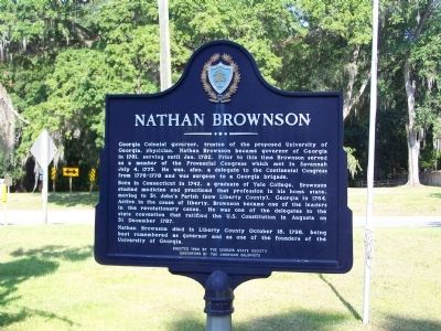
On Ocean Highway (U.S. 17) at Martin Street, on the right when traveling north on Ocean Highway.
Georgia Colonial governor, trustee of the proposed University of Georgia, physician, Nathan Brownson became governor of Georgia in 1781, serving until Jan. 1782. Prior to this time Brownson served as a member of the Provencial Congress which met in . . . — — Map (db m8942) HM
Near East Oglethorpe Highway (U.S. 84) near Lewis Frasier Road.
The Errosion of the Franchise
With the passage of the 14th and 15th amendments to the U.S. Constitution in 1868 and 1869, African Americans were granted full citizenship and the right to vote. In less than a decade, nearly 100,000 black . . . — — Map (db m9065) HM
On Georgia Route 129 at Thrift Lane (County Route 58), on the right when traveling south on Georgia Route 129.
The route intersecting here is the Old Sunbury Road, one of the longest vehicular thoroughfares of the post-Revolutionary Georgia. It was laid out in the early 1790’s from Greensboro via today’s Sparta, Swainsboro and Taylor’s Creek to the town of . . . — — Map (db m54091) HM
On Ocean Highway (State Highway 17) near Adams Street (State Highway 99).
This county, created Dec. 19, 1793 from Liberty County, was named for the McIntosh family, early settlers, whose name was associated with most events in Georgia history for many years. John McIntosh, with 170 Highlanders, came to Georgia in January . . . — — Map (db m10455) HM
On Mulberry Street at New Street, on the right when traveling west on Mulberry Street.
The first Masonic meeting in Georgia was held in 1734 at the town of Sunbury in what is now Liberty County, with General James Edward Oglethorpe serving as Worshipful Master. This was just seventeen years after the formation of the Grand Lodge of . . . — — Map (db m49663) HM
On Ocean Highway (U.S. 17), on the right when traveling south.
Home-site of Dr. Lyman Hall, signer of the Declaration of Independence, member of the First Continental Congress, Governor of Georgia, member of Midway Congregational church near here. Graduate of Yale University, (1747). Born in Wallingford, Conn., . . . — — Map (db m8786) HM
On Ocean Highway (U.S. 17) at Martin Street, on the right when traveling north on Ocean Highway.
Established by South Carolina Calvinists of English and Scottish extraction in 1752, the small settlement of Midway became 'the cradle of the Revolutionary spirit in Georgia'. Two of Georgia's three signers of the Declaration of Independence, . . . — — Map (db m8941) HM
On Ocean Highway (U.S. 17) at Oglethorpe Highway (U.S. 84), on the right when traveling north on Ocean Highway.
he old town of Sunbury, 11 miles East on this road, was a leading port, said to rival Savannah in commercial importance. It was the first Seat of Justice of Liberty County. Sunbury Academy, established in 1788, was in its time the most famous School . . . — — Map (db m8961) HM
On Madison Street near Franklin Street, on the left.
In 1889 the Darien Shortline Railroad was organized to transport yellow pine timber to the Darien sawmills from Georgia`s interior. Originating in Tattnall County and continuing through Liberty County, the Darien & Western line was completed in 1895 . . . — — Map (db m11256) HM
On Georgia Route 23/121 at Canoochee Road, on the left when traveling south on Georgia Route 23/121.
The route crossing at this point is the Sunbury Road, one of the longest vehicular thoroughfares of post-Revolutionary Georgia. It was laid out in the early 1790's from Greensboro via today's Sparta and Swainsboro to the town of Sunbury, a port on . . . — — Map (db m13361) HM
In this, Saint John's Parish, (now Liberty County), lived Button Gwinnett, signer of the Declaration of Independence, member of the Continental Congress, Speaker of the Assembly, and President of the Executive Council. He also was a member of the . . . — — Map (db m8784) HM
On U.S. 17 0.1 miles south of Medway Drive, on the right when traveling north.
Educator, nurse, and author Susannah "Susie" Baker King Taylor was born into an enslaved Geechee family on the Grest Plantation in Liberty County, Georgia. Educated as a child in secret schools in Savannah, she escaped slavery in 1862 during the . . . — — Map (db m132900) HM
This County, created by Act of the Legislature August 14, 1920, is named for Dr. Crawford W. Long who first used ether as an anaesthetic in a surgical operation, at Jefferson, Ga., March 30, 1842. Born in Danielsville Nov. 1, 1815, Dr. Long was a . . . — — Map (db m15085) HM
Through this square ran the southern line of defenses of the British who held Savannah from December 29, 1778 to July 11, 1782. After a siege of 22 days, at dawn of October 9, 1779, the strong western defenses on the line of the present West Broad . . . — — Map (db m71986) HM
On U.S. 1 at Route 57, on the right when traveling south on U.S. 1.
The highway bearing southeastward is the Old Sunbury Road, one of the longest vehicular routes of post-Revolutionary Georgia. It was opened in the early 1790’s from Greensboro via Sparta and Swainsboro to the Town of Sunbury, a port on the Midway . . . — — Map (db m58153) HM
On U.S. 221 0.1 miles south of Coleman Chapel Road (County Route 334), on the right when traveling south.
The highway crosses at this point the former course of the Sunbury road, one of the longest vehicular thoroughfares of post-revolutionary Georgia. It was laid out in the early 1790’s from Greensboro via today’s Sparta and Swainsboro to Sunbury, a . . . — — Map (db m24668) HM
Near Cedar Street 0.2 miles east of Richard Davis Drive.
Ways Station (now Richmond Hill), Station No. 1-1/2 on the Savannah, Albany and Gulf Railroad, was built on land belonging to William J. Way. He was the first station master and co-owner of Silk Hope rice plantation. Construction of the rail line . . . — — Map (db m127220) HM
Near 8787 East Oglethorpe Highway (U.S. 84) near Lewis Frasier Road.
In November 1870, William A. Golding, an African American member
of the Georgia Legislature, wrote the American Missionary Association (AMA) on behalf of the people of Liberty County requesting a teacher. "They want a teacher," he wrote, . . . — — Map (db m9033) HM
On Oglethorpe Highway (U.S. 84) near Lewis Frasier Road, on the right when traveling east.
This Georgian Revival building, built in 1934 to replace an earlier structure destroyed by fire, was once part of an extensive school campus begun in 1871 by the American Missionary Association. The school, founded to serve the educational needs of . . . — — Map (db m89833) HM
On Coastal Highway (U.S. 17) at Martin Road, on the right when traveling north on Coastal Highway.
B. 1744, s/o Bartholomew Ball & Elizabeth Henlen, Craven County, SC, g/s of William Ball (1644 England-1727 SC) & Margaret Sampson, immigrants.
December, 1768: Moved to Liberty County
January 21, 1772: Married Rebecca (Baker) Jones, d/o . . . — — Map (db m205293) HM
On Fort McAllister Road (State Highway 144 Spur) at Bryan Neck Road (State Highway 144), on the left when traveling east on Fort McAllister Road.
The 3rd Cavalry Division (US), Brigadier General H.J. Kilpatrick (US), covered the right rear of General Sherman's army as it closed in on Savannah. On December 12, 1864, Kilpatrick's army crossed the Ogeechee River near Fort Argyle and the . . . — — Map (db m279186) HM
On Abercorn Street, on the right when traveling north.
James S. McIntosh achieved an immortal record of gallantry in the War of 1812 and in the War with Mexico. In 1814 he saw considerable action on the Canadian border, he was severely wounded at Buffalo. In the Mexican War, Col. McIntosh was . . . — — Map (db m81621) HM
On Goulding Place 0.1 miles west of Canton Street, on the left when traveling west.
Francis Robert Goulding, author, clergyman, inventor, lived in this house at the time of his death, August 22, 1881, and is buried in the Roswell Presbyterian Cemetery. The son of Rev. Thomas Goulding, founder and first president of the Presbyterian . . . — — Map (db m10860) HM
On Oglethorpe Highway (U.S. 84) near 101st Coast Artillery Dr, on the left when traveling west.
Returning from the Revolution, the soldiers of Liberty County re-organized themselves into a troop of cavalry, known as the Liberty Dragoons, later the Liberty Independent Troop, the oldest cavalry company in Georgia. In continuous existence since . . . — — Map (db m8998) HM
Near Ocean Highway (U.S. 17) near Martin Street, on the right when traveling north.
On Dec. 13, 1864, Murray's brigade of Kilpatrick's cavalry division (USA), scouting in the right rear of Gen. Sherman's army, which was then closing in on Savannah, moved south into Liberty County. After driving back the 29th Georgia Cavalry . . . — — Map (db m41685) HM
Born in Franklin County, Georgia
January 25, 1803 Died at Liberty, Texas, April 20 1878 An officer at the Siege of Bexar and at San Jacinto 1837 appointed by Congress Surveyor of Liberty County 1841, Colonel of the 2nd Regiment of the 2nd . . . — — Map (db m195844) HM
On Fort McAllister Road (State Highway 144 Spur) at Bryan Neck Road (State Highway 144), on the right when traveling east on Fort McAllister Road. Reported permanently removed.
On Dec. 12, 1864, the 3rd Cavalry Division [US], Brig. Gen. J. L. Kilpatrick, USA, covering the right rear of Gen. Sherman's army which was then closing in on Savannah, crossed the Great Ogeechee River near Fort Argyle and the Canoochee River . . . — — Map (db m279185) HM
On South Main Street (Loop Georgia Route 138) south of Bagley Avenue, on the right when traveling north.
While this building was not Liberty County's first jail, it served longer than any previous jail. When in was built in 1892 the jail had "all the modern improvements and conveniences of a first class prison." Eighty years later it was condemned by . . . — — Map (db m41682) HM
On North Coastal Hwy (U.S. 17) near Martin Street, on the right when traveling north.
Organized in 1754 by the descendants
of an English Colony which came first
to Massachusetts 1630
to Connecticut 1635
to South Carolina 1695
and to Georgia 1752
Built on the same spot as the church
which was burned by the British in . . . — — Map (db m8999) HM
On East Oglethorpe Highway (U.S. 84) near Lewis Frasier Road.
J. Roosevelt Jenkins, who was Dorchester
Academy's assistant principal, science
teacher and athletic director, replaced
Elizabeth Moore as principal after her death
in 1932. He continued to strengthen the
school's curriculum and the . . . — — Map (db m9058) HM
On Tibet Road at Sandy Run Road, on the right when traveling south on Tibet Road.
This church was the first colony to go out from old Midway Congregational Church. The first building was erected in 1820 on land donated by Andrew Walthour. The present one, constructed near the original site in 1884, replaced buildings destroyed by . . . — — Map (db m58139) HM
On U.S. 280 at Sunbury Road, on the right when traveling east on U.S. 280.
The highway leading south is a remnant of
the Old Sunbury Road, one of the leading
vehicular thoroughfares of post-Revolutionary
Georgia. It was laid out in the early 1790's
from Greensboro via Sparta and Swainsboro to
the Town of Sunbury, . . . — — Map (db m18621) HM
On Lewis Frasier Road near East Oglethorpe Highway (U.S. 84), on the right when traveling west.
In an effort to involve Liberty County African Americans in politics, the Dorchester Cooperative Center (DCC) began to help organize
African American Voters. The DCC taught local African Americans the United States and Georgia constitutions, . . . — — Map (db m8968) HM
Near Capitol Avenue Southwest south of M.L.K. Junior Drive Southeast, on the left when traveling north.
Expelled Because of Color” is dedicated to the memory of the 33 Black state legislators who were elected, yet expelled from the Georgia House because of their color in 1868.
The cinder block forms at the base of the sculpture symbolize the . . . — — Map (db m130191) HM
Near East Oglethorpe Highway (U.S. 84) near Lewis Frasier Road.
The Old Midway Congregational Church, two
miles east on U.S. Highway 17, was formed
by whites (Puritans & Congregationalists )
when they settled in Liberty County. They
were driven to church by their black slaves
who were allowed to sit in . . . — — Map (db m9070) HM
Thin black lines indicate changes in relevance. Between each pair of lines entries are ordered geographically but all have the same relevance.
* Inflectional forms of words are their plurals, singulars, and possessives as well as gramatical tenses and similar variations.