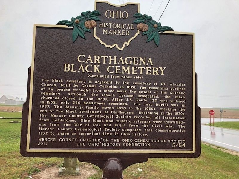
On Ohio Route 274 at U.S. 127, on the right when traveling east on Ohio Route 274.
The Carthagena Black Cemetery (Union Cemetery) is a remnant of approximately 70 documented rural black and mulatto rural settlements established throughout Ohio before the Civil War. After the Cincinnati riots against blacks in 1829, Quaker . . . — — Map (db m110110) HM
On East Market Street, on the right when traveling east.
The museum of the Mercer County Historical Society, the Riley Home, represents six generations of the Riley family in the county. The first Riley to arrive here was Captain James Riley, who surveyed the area in 1819, after it was opened to . . . — — Map (db m12294) HM
In 1885, 800 feet north of this marker, Benjamin Faurot struck oil after drilling into the Trenton Rock Limestone formation at a depth of 1,251 feet. This event marked the beginning of the great Oil Boom of northwest Ohio. The ensuing rush brought . . . — — Map (db m22931) HM
Near Emmy Place (U.S. 65) just north of Design Place (Empire Loop), on the right when traveling north.
[side 1] Here in Missouri's north central glacial plains, Mercer County was organized, 1845. Named for Rev. War Gen. Hugh Mercer, the county is in territory ceded by Iowa, Sac, and Fox tribes in 1824. Indians hunted in the . . . — — Map (db m179701) HM
On East Main Street (Ohio Route 119), on the right when traveling east.
In July, 1837, Henry Romer platted the village of St. Henry, Ohio. The Romer (Roemer), Bruns, Beckman, Wimmers, Borgelt, Athmer, Wendell, Grievenkamp, Huelsmann, Brockmann, and Hemmelgarnn families were among those early settlers of the 1830’s . . . — — Map (db m116854) HM
On Reynolds Industrial Park Road (Pennsylvania Route SR 4012) at West Kidd's Mill Road, on the right when traveling east on Reynolds Industrial Park Road.
Built in 1868, spanning the Shenango River. The only remaining bridge in Pennsylvania with an all-wooden truss design patented by Robert Smith of Tippecanoe City, Ohio. The last historic covered bridge in Mercer County, extending 120 feet in length . . . — — Map (db m22619) HM
On S. Main Street, on the left when traveling south.
Named for General Hugh Mercer, a distinguished officer of the Revolution, Mercer County was established in 1820 by a
legislative act creating counties from the land within Ohio ceded by the Indians. The configuration of the County
then included . . . — — Map (db m193092) HM
On East End Avenue, on the right when traveling north.
Patriotism has aiways been a Beaver County trait, and it was no different when the Civil War exploded on the scene. Eleven of the
270 regiments that the State of Pennsylvania raised contained one or more companies composed of Beaver County men, and . . . — — Map (db m176994) HM
Near Kings Chapel Road at Pulaski Road, on the right when traveling south.
European Contact: 17th and 18th Centuries
17th Century
French and English fur traders and explorers began to traverse the Allegheny Mountains in the late 17th century. The American Indians traded primarily beaver, mink, and other . . . — — Map (db m235182) HM
On South Main Street (U.S. 127) 0.1 miles south of Lake Shore Drive, on the right when traveling north.
1. Eden Haden Park
This 55 acre Mercer County park was established in 1972. It is located on Haden Road
4 miles north of SR 29. It has a dense wood lot along with a 2 acre pond and
playfield. It and farmland to support its maintenance were . . . — — Map (db m166630) HM
On Zimmerlin Road at McFarland Road, on the right when traveling east on Zimmerlin Road.
Side A: Randolph Settlement
In 1833, John Randolph from Roanoke, Virginia, died leaving three wills that requested that all of his slaves be set free and that land be purchased for them. Although contested for thirteen years by his family, . . . — — Map (db m111980) HM
On East Main Street (County Route 151) just east of North Kanawha Street, on the right when traveling west.
Explorations of West Blue Ridge
It is impossible to say when and where the first European settlers set foot on the soil of what is now West Virginia. In all probability no record was ever made of the first visit. It is well known that . . . — — Map (db m179016) HM
On 7th Street east of Lafayette Avenue (West Virginia Route 2), on the left when traveling east.
Moundsville. Named for Grave Creek Mound. This mound, 900 feet around, 70 feet high, is the largest conical mound in America. The inscribed stone found in it has never been deciphered. Near by was the Indian fort built by Joseph Tomlinson.
. . . — — Map (db m20373) HM
On Gwendolyn Street south of Washington Street, on the right when traveling south.
Pioneer Cemetery is the oldest cemetery in Mercer County, with burials from 1812 to 1873. Those buried here were some of the first Euro-Americans who settled the area. Many of these families helped lay out the town of Fort Recovery, established . . . — — Map (db m137521) HM
On South Diamond Street (Pennsylvania Route 258) east of Erie Street (U.S. 19), on the right when traveling east.
This house
was the boyhood home of
John A. Bingham
Born in Mercer in 1815
⛛
Judge Advocate at the trial of the Conspirators
in the assassination of Abraham Lincoln
Representative in Congress from Ohio . . . — — Map (db m265574) HM
On Main Street (County Route 120) at Simmons Avenue, on the left when traveling east on Main Street.
While the description of Bramwell as a town of millionaires can be
viewed as an exaggeration, it did have a significant number of wealthy
families. Their wealth was built largely upon the rapid growth of the
Pocahontas coalfield and Bramwell’s . . . — — Map (db m179168) HM
Thin black lines indicate changes in relevance. Between each pair of lines entries are ordered geographically but all have the same relevance.
* Inflectional forms of words are their plurals, singulars, and possessives as well as gramatical tenses and similar variations.