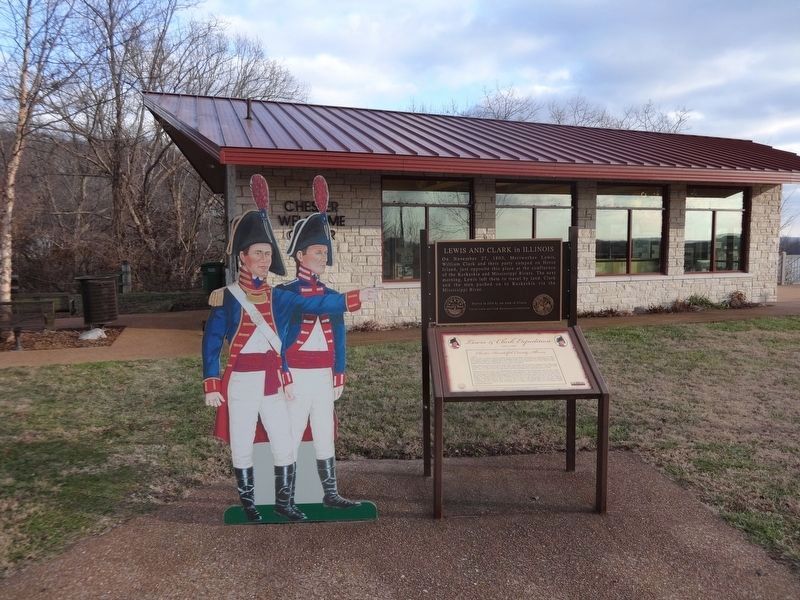
On Bridge Bypass Road (Illinois Route 150) at Kaskaskia Street, on the right when traveling north on Bridge Bypass Road.
The town of Chester, Illinois, sprawls on the eastern bluffs overlooking the November 27, 1803, Horse Island campsite of Captain Lewis and William Clark on the west bank of the Mississippi River near its confluence with the Kaskaskia River. The . . . — — Map (db m144872) HM
On West Taylor Street (Illinois Route 150) east of Chestnut Street, on the right when traveling east.
The Village of Kaskaskia was established in April 1703 by the French in Illinois Country of New France. Kaskaskia is recognized as the oldest seat of organized government west of the Allegheny Mountains.
On April 18, 1818, the United States . . . — — Map (db m163829) HM
On St. Leo's Road (County Route 23) north of Bluff Road.
George Fisher, early Illinois physician, served as sheriff of Randolph County, member of the first House of Representatives of Indiana Territory, Speaker of the House in the first and third Illinois Territorial Assemblies, (1812-1814, 1816-1818), . . . — — Map (db m161312) HM
On Schuline Road (County Route 4) east of Orchard Road, on the right when traveling east.
Charter Oak School is said to be the only octagonal one-story brick schoolhouse in Illinois. It was built in 1873, in accordance with a design suggested by Daniel Ling, a teacher of the Charter Oak School district. It served as a school until . . . — — Map (db m161316) HM
On Levee Road 3.3 miles south of Roots Road, on the left when traveling south.
Mississippi River Flooding and the Demise of Old Kaskaskia
Kaskaskia Village was the Randolph County seat of government from 1795 until 1844 when a massive flood extensively damaged the village, and the county seat was moved to Chester. . . . — — Map (db m257360) HM
On Levee Rd. 1 mile south of Roots Rd., in the median.
1703 - The Illini tribes establish a village on the Kaskaskia River seven miles north of its confluence with the Mississippi. The Jesuits and other French people in the area settle in with the natives. The historic French colonial village of . . . — — Map (db m192533) HM
On Market Street 0.1 miles north of Court Street, on the right when traveling north.
The formation of Randolph County in 1795 proceeded Illinois' statehood by 25 years. By act of the state legislature in 1821, the settlement of Prairie du Rocher became an official village within the state of Illinois. Trustees were appointed for . . . — — Map (db m206162) HM
Near South Feazel Street just north of Bauman Lane, on the right when traveling north.
This cabin was also known as the Wilson Cabin, the mystery cabin and the Dodd Gibson property. The cabin was built about 1790 on a cliff's edge overlooking the Ohio River at Elizabethtown, Illinois. The site afforded a view of the river more than 10 . . . — — Map (db m146878) HM
On Main Street (Illinois Route 3) at Route 155, on the right when traveling south on Main Street.
Dr. George Fisher, Kaskaskia physician, lived on a farm eight miles west of here from 1806 until his death in 1820. 1801 First Sheriff of Randolph County, 1805-1808 Member of the first and second General Assemblies of Indiana Territory, 1812-1816 . . . — — Map (db m161315) HM
On Kaskaskia Street (County Road 6) at Shaweeneetown Trail (County Road 3), on the right when traveling west on Kaskaskia Street.
This region lowered the French Bourbon flag in October 1765 when the territory fell under British control. A British military report commissioned a few years later states that the French redoubt here called Fort Kaskaskia had been burned and . . . — — Map (db m302431) HM
On South 3rd Street (County Route 7) south of East Seldon Street, on the left when traveling south.
In the third year of the American War for Independence, Lt. Col. George Rogers Clark and his army of 170 Virginia volunteers camped 5 miles southeast of here. On July 2, 1778, Clark made the fourth of five camps on his march from Fort Massac to . . . — — Map (db m161442) HM
On Airport Road at Glenn Road, on the right when traveling west on Airport Road.
Lt. Col. Clark and his troop of 170 Virginians camped near here on July 2, 1778. It was their third campsite during a march from Fort Massac to Kaskaskia to capture that post from the British. Earlier that day, the troop was lost for a time on . . . — — Map (db m161008) HM
On U.S. 45 (U.S. 45) south of Westview Road, on the right when traveling south.
Lt. Col. George Rogers Clark and his troop of 170 volunteers, principally Virginians, camped near this site, called Indian Point, on June 30, 1778. They were marching from Fort Massac to attack the British post at Kaskaskia. This was the first of . . . — — Map (db m146332) HM
Near Illinois Route 150 0.2 miles south of Briarhill Road.
Shadrach Bond, first Governor of Illinois (1818-1822), is buried in Evergreen Cemetery in Chester. The first recorded settler in the area was John McFerron who purchased land in 1817 but Samuel Smith, who settled here in 1830, is considered the . . . — — Map (db m316215) HM
Near West Holmes Street (Illinois Route 3) south of Bridge Bypass Road.
Elias Kent Kane, architect of the state's first constitution was born in New York in 1794. Kane studied law and began his practice in Tennessee. In 1814 he moved to Kaskaskia, where he was appointed a judge of the Illinois Territory. Active in . . . — — Map (db m161382) HM
On East Kaskaskia Street (County Road 6) south of Kane Hill Road, on the left when traveling south.
Reily Lake, once a thriving community the
Kaskaskia-Cahokia Trail in Randolph County
played an important role in the development of
the Illinois Country
Frenchman Prix Paget (Pagi) erected one of the first water
mills in Illinois in . . . — — Map (db m292383) HM
William Hix operated the first ferry in Arkansas sometime around 1803 over the Current River, which separates northeastern Randolph County from Missouri. It was on the Natchitoches Trace, also known as the Old Southwest Trail. This important road . . . — — Map (db m170295) HM
On Park Road 0.5 miles Shawneetown Trail (County Route 3), on the right when traveling east.
For more than 80 years, this shelter stood sentinel over the confluence of the Kaskaskia and Mississippi Rivers…one of the most beautiful views in North America. Over the decades, thousands of visitors, families and friends enjoyed the shelter for . . . — — Map (db m163785) HM
John B. E. Canal
A representative from
Madison County in the
General Assembly of Illinois
Born at Baltimore
June 24, 1809
Died at Vandalia
December 31, 1830
Benjamin A. Clark
Representative of the
General Assembly . . . — — Map (db m42627) HM
On West Hood Avenue at North St. Louis Street, on the right when traveling west on West Hood Avenue.
In memory of Revolutionary War soldiers
buried in Randolph County, Illinois
Joseph Anderson ·
Bazelle Allere ·
Joseph Allere ·
Michael Antere ·
Antoine Bienvenue ·
Daniel Blouin ·
Jean Baptiste Baroau ·
Robert Bratney · . . . — — Map (db m287089) HM WM
Thin black lines indicate changes in relevance. Between each pair of lines entries are ordered geographically but all have the same relevance.
* Inflectional forms of words are their plurals, singulars, and possessives as well as gramatical tenses and similar variations.