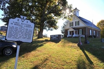
On Virginia Route 71 at Lower Copper Creek Road (County Route 678), on the left when traveling west on Virginia Route 71.
In 1787, Isaiah Salyer (1752-1818), son of
Zachariah Salyer (1730-1789) of North Carolina
settled on Copper Creek, two miles southeast
of here. Isaiah's brothers John, Benjamin, and
Zachariah, and sisters Sarah, wife of Solomon
Saylor, and . . . — — Map (db m89849) HM
On Dickenson Highway (Route 83) at Greenbrier Road, on the right when traveling east on Dickenson Highway.
Buchanan County Formed in 1858 from Tazewell and Russell, and named for James Buchanan, President of the United States, 1857-1861.
Dickenson County Formed in 1880 from Russell, Wise and Buchanan, and named for W. J. Dickenson, prominent . . . — — Map (db m228613) HM
On Porterfield Highway (U.S. 19) 0.5 miles south of Clinch Mountain Road, on the right when traveling south.
Russell County
Russell County was formed from Washington County in 1786. The county is named for William Russell, a Clinch Valley pioneer and member of the Virginia House of Delegates who introduced the legislation forming the county. The Clinch . . . — — Map (db m234572) HM
On Plumb Alley east of Brewers Alley, on the left when traveling east.
Walnut Grove, a recreation of an early Appalachian homestead, is an authentic representation of what was common to pioneer life in this region from the late 1700's until the early 1900's.
Beginning with a simple log cabin, pioneer settlers, over . . . — — Map (db m210000) HM
On Old Wilderness Road (Virginia Route 58) 0.2 miles north of Route 872, on the right when traveling west.
Lee County. Lee County, the western-most county in Virginia, was formed from Russell County in 1792; a part of Scott County was added later. The county is named for Henry "Light Horse Harry" Lee, governor of Virginia from 1791 to 1794 and . . . — — Map (db m80237) HM
Near Jerry West Highway (West Virginia Route 44) 0.5 miles south of Philips Street, on the right when traveling south.
Descended from English settlers, the Hatfield clan made its way to western Virginia by the 1770s. The first Hatfield to arrive at Tug Fork Valley was Ephraim, nicknamed "Eph-of-All", from Russell County, Virginia. He and his second wife, Anna . . . — — Map (db m306427) HM
On U.S. 460 south of Shortt Gap Road, on the right when traveling north.
Buchanan County Buchanan County is situated in the heart of
Southwest Virginia's coalfields in the Appalachian
Plateau and was formed from Tazewell and
Russell counties in 1858. The county is named
for James Buchanan who served as . . . — — Map (db m228601) HM
On U.S. 23 0.8 miles south of Jasper Road, on the right when traveling south.
Lee County. Lee County, the western-most county in Virginia, was formed from Russell County in 1792; a part of Scott County was added later. The county is named for Henry “Light-Horse Harry” Lee, governor of Virginia from 1791 to 1794 and . . . — — Map (db m228717) HM
On Green Spring Road at Gibson Street SE, on the right when traveling north on Green Spring Road.
Black's Fort History
from History of Southwest Virginia, 1746-1786
Washington County 1777-1870
by
Lewis Preston Summers
In 1760, what was to become Abingdon received its first name, Wolf Hills, from Daniel Boone after his hunting party was . . . — — Map (db m210058) HM
On Orby Cantrell Highway (U.S. 23) 0.4 miles south of Baxley Lane, on the right when traveling south.
Lee County, the western-most county in
Virginia, was formed from Russell County in
1792; a part of Scott County was added
later. The county is named for Henry “Light-
Horse Harry” Lee, governor of Virginia
from 1791 to 1794 and former . . . — — Map (db m228710) HM
On Orby Cantrell Highway (U.S. 23), on the right when traveling south on Orby Cantrell Highway.
Wise County. Wise County was formed in 1856 from Lee, Scott,
and Russell Counties. It was named for Henry
Alexander Wise who was governor of Virginia
from 1856 to 1860. The county seat is the town
of Wise. After the Civil War the town of . . . — — Map (db m90800) HM
On Virginia Route 80 just west of County Route 620, on the left when traveling west.
Helen Timmons Henderson, born in Missouri and
raised in Tennessee, was one of the first two
women elected to Virginia’s General Assembly.
She and her husband moved to Council in 1911
when the Baptist State Mission Board of Virginia
recruited . . . — — Map (db m104934) HM
On Clintwood Highway (Virginia Route 83) at the county line, on the right when traveling east on Clintwood Highway.
Wise County. Wise County was formed in 1856 from Lee, Scott,
and Russell Counties. It was named for Henry
Alexander Wise who was governor of Virginia
from 1856 to 1860. The county seat is the town
of Wise. After the Civil War the town of . . . — — Map (db m90775) HM
On East Main Street (Business U.S. 19) east of Memorial Drive (County Road 1045), on the left when traveling east.
Charlie Fields was a well loved man in his community. He was born in a small four room house, located on Big Cedar Creek, just on the outskirts of Lebanon in Russell County, Virginia. Charlie was the son of William "Bill" Fields and Sara "Dealie" . . . — — Map (db m305194) HM
On Trail of the Lonesome Pine (Alternate U.S. 58) east of Upper Copper Creek Road (County Route 671), on the left when traveling east.
This building, erected in 1792, served as the
second courthouse of Russell County and is one
of the earliest public buildings still standing
in Southwest Virginia.
Russell County was
formed in 1786 from Washington County and
originally . . . — — Map (db m91034) HM
On Virginia Route 71 at Lakeview Circle (County Route 785), on the right when traveling south on Virginia Route 71.
William Dorton Sr.
and his family, settled
here by 1773 and built a fort, one of
several defensive structures built by settlers
of European descent on the Virginia frontier.
Dorton's sons William Jr. Moses
fought in the Revolutionary War
and . . . — — Map (db m89847) HM
Thin black lines indicate changes in relevance. Between each pair of lines entries are ordered geographically but all have the same relevance.
* Inflectional forms of words are their plurals, singulars, and possessives as well as gramatical tenses and similar variations.