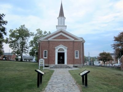
Near South College Street (U.S. 127) at West Lexington Street, on the right when traveling south.
The marriage of Thomas Lincoln and Nancy Hanks took place on the Beechland property of Nancy’s uncle, Richard Berry Sr., in Washington County, about twenty-five miles southwest of here, on June 12, 1806. The ceremony was presided over by the . . . — — Map (db m46317) HM
First governor of Kentucky
1792-1796
Fifth governor of Kentucky
1812-1816
One of Shelby’s first acts as Governor was to call for and help design the Great Seal of the Commonwealth of Kentucky. The figures of a pioneer and statesman in this . . . — — Map (db m121734) HM
On Lincoln Park Road (Kentucky Route 528) north of Mudd & Kelly Lane, on the right when traveling north.
Built in 1797, the Mordecai Lincoln House is one of two structures in Kentucky, of those formerly owned by members of President Lincoln's family, which still stands largely intact on its original site. Mordecai Lincoln purchased 400 acres for 100 . . . — — Map (db m250702) HM
Near Old Kentucky Route 53 0.1 miles north of Gregory Lane, on the left when traveling north.
Sarah Mitchell Thompson, first cousin and best friend of Nancy Hanks Lincoln, mother of President Lincoln, is buried here at Pleasant Grove Cemetery. Abducted by Native Americans near Crab Orchard, Kentucky, she was released from captivity in . . . — — Map (db m250708) HM
On Beechland Road (Kentucky Route 438) 0.2 miles north of Lincoln Park Road ( Route 528), on the right when traveling north.
Captain Abraham Lincoln, Sr,, grandfather of the 16th president, was
killed near his home by Lincoln's Run in Washington County April
1788 by a Native American. Latitude: 37.77081 Longitude: -85.21509.
He was buried in The Pioneer Cemetery . . . — — Map (db m250705) HM
On Beechland Road (Kentucky Route 438) 0.2 miles north of Berry Mill Road, on the right when traveling north.
Thomas Lincoln and Nancy Hanks took up housekeeping here on September 21, 1805. Built about 1780 by Richard Berry, Sr., the cabin provided temporary lodging when Berry acquired 600 acres at Beechland.
Thomas and Nancy's first child, Nancy, died . . . — — Map (db m250706) HM
Near Beechland Road (Kentucky Route 438) at Lincoln Park Road ( Route 528), on the left when traveling east.
Thomas Lincoln
Thomas Lincoln was born on January 7, 1778, in Rockingham County, Virginia, to Captain Abraham and Bathsheba Lincoln. He was the youngest of three sons and the fourth of five children. The Lincoln family migrated from . . . — — Map (db m46311) HM
Near East Lincoln Highway Road west of County Road 1300E.
Thomas Lincoln, like most adult white men in the United States, was obliged to serve in his state's militia. In 1795, at the age of seventeen, he served a few months "for the defense of the frontiers of Washington County" Kentucky against Indian . . . — — Map (db m188286) HM
On Beechland Road (Kentucky Route 438) at Lincoln Park Road ( Route 528), on the left when traveling east on Beechland Road.
Pioneer Spirit
The westward movement was an enticement felt by many nineteenth century families, and the Lincolns were in the heart of it. A friend of the family was the infamous frontiersman Daniel Boone, and it has been reasoned that . . . — — Map (db m46249) HM
On Mackville Hill Road (Kentucky Route 152) at Mackville Elementary School Drive, on the right when traveling east on Mackville Hill Road. Reported unreadable.
John Hunt Morgan and his men arrived in Mackville on Saturday evening, July 12, 1862, following raids on Lebanon and Springfield. Shortly after their arrival a skirmish ensued between Morgan’s men and the Home Guard. The Home Guard took two . . . — — Map (db m152653) HM
Near Beechland Road (Kentucky Route 438) at Lincoln Park Road ( Route 528), on the left when traveling east.
The Lincoln Cabin is a replica of the cabin in which President Abraham Lincoln’s grandmother Bersheba Lincoln, lived and raised her children after the death of her husband, Abraham.
In the spring of 1786, Abraham and Bersheba Lincoln were . . . — — Map (db m46305) HM
Near Beechland Road (Kentucky Route 438) at Lincoln Park Road ( Route 528), on the left when traveling east.
President Abraham Lincoln’s great, great, great, great grandfather, Samuel Lincoln, left England in 1637, settling in Hingham, Massachusetts. The next four generations of Lincolns continued to move south and west — to New Jersey, then . . . — — Map (db m46301) HM
On West Main Street (Business U.S. 150) at Cross Main Street, on the right when traveling east on West Main Street.
The Lincoln Legacy
Ca. 1782 The Lincoln, Hanks, Berry and Shipley families begin migrating to the Beech Fork in Kentucky.
1806, June 12 Nancy Hanks and Thomas Lincoln are married by Reverend Jesse Head at the home of Francis Berry in . . . — — Map (db m283424) HM
On W Dixie Avenue at N. Mulberry Street (U.S. 62), on the left when traveling east on W Dixie Avenue.
Shortly after Thomas and Nancy Lincoln's wedding in Washington County on June 12, 1806, the couple set up housekeeping in Hardin County where Thomas owned a farm near Elizabethtown on Mill Creek. Nancy gave birth to Lincoln's first child, a daughter . . . — — Map (db m249363) HM
The following three patriots are interred in Section OP. Lots 26. 106, and 214.
ELIJAH SMITH
Born on August 12, 1755, near Trenton, Hunterdon County. New Jersey. Died March 11, 1836 at age 80 in Illinois. Enlisted the first time in 1776 . . . — — Map (db m287414) HM WM
On South College Street (U.S. 127) at West Lexington Street (U.S. 68) when traveling south on South College Street.
Revolutionary Soldier
Kentucky Pioneer
Christian Patriot
Born in Ireland, 1750 Died in Kentucky, 1848. First to be buried in Memorial Acre, 1930
When a lad he emigrated to America and fought in the battles of Paoli, Boundbrook, . . . — — Map (db m269106) HM
Near Beechland Road (Kentucky Route 438) near Lincoln Park Road ( Route 528), on the left when traveling east.
On June 12, 1806, Thomas Lincoln traveled to Springfield, Kentucky, to obtain a marriage license to wed Nancy Hanks. Richard Berry, Nancy's uncle, signed the document as guardian of the bride-to-be. Two days later, Thomas Lincoln and Nancy were . . . — — Map (db m46314) HM
On Fort Chiswell Road (U.S. 520) just south of Austinville Road (County Route 619), on the left when traveling south.
Fincastle County, established in 1772, was formed from Botetourt County. The Fincastle County seat was located opposite the lead mines on the north side of the New River in the western end of present day Austinville. In 1775, the Fincastle County . . . — — Map (db m43358) HM
Near Beechland Road (Kentucky Route 438) at Lincoln Park Road ( Route 528), on the left when traveling east.
Thomas Lincoln proposed to Nancy Hanks in this house, originally located on Beech Creek about one mile from here. At the time, Nancy was living with her cousin, Francis Berry, and his family.
Lucy Shipley Hanks and her daughter, Nancy, . . . — — Map (db m46270) HM
On Farm to Market Road 1603 at Rice Road on Route 1603.
Chatfield, a prosperous farming community, was the site of the organization of the Baptist General Association of Texas on July 17, 1868. Originating in the mid-1840s as a trading post established near a spring by Indian trader Norman Chatfield, it . . . — — Map (db m217188) HM
On Martin Luther King Avenue at Kobert Avenue, on the left when traveling east on Martin Luther King Avenue.
The home was known for years as the old Kobert place, for it was the home of the late Charles Kobert for about 50 years. Mr. Kobert was deeded the property on December 6, 1883 from L. A. Spalding. The first known history on the property is that in . . . — — Map (db m99405) HM
On East Main Street west of East Ballard Street, on the right when traveling east.
Word of Morgan's raid on Lebanon on July 12 quickly reached Springfield, a tiny village of 500 residents. After hearing news of the raid, F.L. Davison, prominent local planter and businessman, sent Springfield resident John Meeks to the neighboring . . . — — Map (db m99458) HM
Near MP Daniel Esplanade at South 5th Street, on the right when traveling north.
World's largest Baptist University. Founded under charter issued by Congress of Republic of Texas on Feb. 1, 1845, and in continuous operation ever since.
Named for Judge R. E. B. Baylor (1791-1873), a native of Kentucky, an 1820s United . . . — — Map (db m180289) HM
On Lincoln Park Road, on the left when traveling north.
When building lots were first surveyed for Springfield’s downtown, this location was much sought after because of its proximity to the courthouse. William Pile had a storehouse here in 1797, and John Lancaster owned the lot in 1813. Prior to 1876, . . . — — Map (db m121745) HM
In Late March 1836, the Texian Army was in retreat ahead of Santa Anna's advancing Mexican forces. The retreat spurred the "Runaway Scrape" - a wave of settlers fleeing for their lives. To prevent the enemy from benefitting from San Felipe's . . . — — Map (db m206186) HM
With his Empresario contract in hand, Stephen F. Austin searched out a suitable location for the "capital" of his colony. Together with surveyors and guides, Austin selected a site where a ferry crossed the Brazos River. By late October . . . — — Map (db m206331) HM
Near North Street (Business U.S. 59) north of Griffith Boulevard, on the right when traveling north.
Republics often point to one person whose vision and leadership led to their creation. For the Republic of Texas (1836-1845) that person is Stephen Fuller Austin.
Austin, the son of Moses and Maria Brown Austin, was born on the Virginia . . . — — Map (db m313281) HM
Near South College Street (U.S. 127) at West Lexington Street, on the right when traveling south.
The Lincoln family first came to America in the seventeenth century, originally settling in the Massachusetts Bay colony. The Lincolns continued to move throughout the colonies, settling in present-day New Jersey, Pennsylvania, and Virginia. Thomas . . . — — Map (db m46319) HM
Near Beechland Road (Kentucky Route 438) at Lincoln Park Road ( Route 528), on the left when traveling east.
The Nancy Hanks Memorial was constructed to honor the mother of President Abraham Lincoln. The native limestone memorial was dedicated on June 12, 1935, the 129th anniversary of the marriage between Thomas Lincoln and Nancy Hanks.
Three young . . . — — Map (db m46263) HM
Near Old Stage Coach Road 0.1 miles east of Long Run Road, on the right when traveling east.
This spot was frequented by the ancestors of two presidents of the United States of America, namely Abraham Lincoln (1809-1865) and Harry S. Truman (1884-19 ).
The old church ruins occupy a site selected by Captain Abraham Lincoln . . . — — Map (db m203147) HM
On East Main Street (Kentucky Route 152) east of Walnut Street ( Route 1584), on the left when traveling east.
On Tuesday morning, December 30, thirty-nine hundred Confederate cavalrymen led by John Hunt Morgan left Bardstown, making every effort to beat the Union forces to the Cumberland River crossing at Burkesville. Their progress was hampered by a cold . . . — — Map (db m99437) HM
Pathway to a Political Future
Born near Greenville, South Carolina, January 26, 1790, Daniel Dunklin moved first to Kentucky and then to Missouri, settling with his widowed mother at Mine-a-Breton, near Potosi, in 1810. Dunklin studied law . . . — — Map (db m248681) HM
Born in Washington County, Tennessee, Henry Melville Doak was an adventurous young man who tried twice, at age 4 and at 7, to run away from home and join the militia headed off to fight in the Mexican War. Several years older, he gave up the study . . . — — Map (db m166491) HM
On Federal Lane 0.2 miles east of Tennessee Route 22, on the right when traveling east.
Cyrus Livingston Dunham left a promising political career to serve his country in the Civil War. He resigned his military commission November 18, 1863, his health broken
A Rural Upbringing
Cyrus Dunham was born and raised on a farm . . . — — Map (db m174108) HM
On Old Saint Stephens Road 1.2 miles east of Cement Plant Road, on the right when traveling west.
The St. Stephens Historical Commission was chartered by the State of Alabama in 1988: The board is charged with "acquiring, maintaining, protecting, promoting, and preserving" Alabama's first capital, St. Stephens.
Washington . . . — — Map (db m294044) HM
On Tebbs Bend Road 0.3 miles west of New Columbia Road ( Route 55), on the left when traveling west.
Major Edward P. Byrne
Commander of the Confederate Artillery
A native Kentuckian, Byrne was living in Greenville, Washington County, Mississippi, when the war broke out. His first battery of six brass field pieces, their carriages, and . . . — — Map (db m133838) HM
On Pine Street West at Third Street South (County Highway 23), on the left when traveling west on Pine Street West.
Dedicated to the
Soldiers and Sailors of the
United States
Enlisting or Residing in
Washington County
———
Erected by the Citizens of
Washington County
1916
center panel
Minnesota
Alcorn James 2nd Cav. •
Barrisford . . . — — Map (db m72153) WM
Thin black lines indicate changes in relevance. Between each pair of lines entries are ordered geographically but all have the same relevance.
* Inflectional forms of words are their plurals, singulars, and possessives as well as gramatical tenses and similar variations.