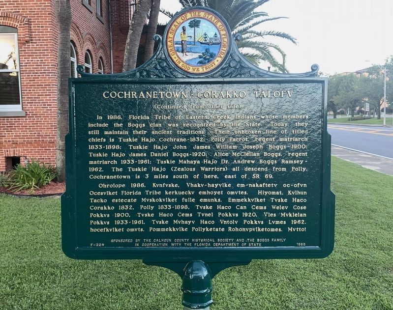
On East Central Avenue (State Road 20) at Main Street (State Road 71), on the right when traveling west on East Central Avenue.
(This is Florida's first bi-lingual marker. The second language is Apalachicola Muskogee/Creek.) Apalachicola Creek Indians permanently settled Calhoun County in 1815; wars forced them out of Alabama. A new Tribal Town was built by Chief Tuskie . . . — — Map (db m48489) HM
On Central Avenue (State Road 20) at Main Street (State Road 71), on the right when traveling west on Central Avenue.
This is the western boundary of a reservation set aside by the treaty of Fort Moultrie and given to John Blunt (Blount) one of the six principal chiefs of the Florida Indians. The Apalachicola River was the eastern boundary. The treaty was ratified . . . — — Map (db m78029) HM
On Chipola Street (County Route 274) 1.3 miles west of North Main Street (Florida Route 71), on the right when traveling west. Reported missing.
On this site are the remains of early area settlers, the Richards family. As a prominent Virginia Colonial family, George Richards (1727-1818) was with Washington at Braddocks Defeat (1755), and with his sons in the Revolutionary War (1776). The . . . — — Map (db m186749) HM
On Central Avenue (Florida Route 20) at Southeast River Street, on the right when traveling east on Central Avenue.
In recognition of
Apalachicola Tribal Town
Mekko John Blount
and the Muskogee (Creek) Nation
Reservation that existed on these lands,
where this marker stands.
The Muskogee (Creek) Nation was forcefully
removed from Florida . . . — — Map (db m246849) HM
On Court Square (State Highway 28) south of Washington Street (State Highway 203), on the right when traveling north.
Abbeville's 6th courthouse - designed in beaux arts classical style by Edwards & Walter of Atlanta - dedicated in 1908 with City Hall/Opera House. (Two buildings indirectly financed by profits from Abbeville Dispensary, only one still operating . . . — — Map (db m14870) HM
On Railroad Avenue at North Pear Street, on the right when traveling west on Railroad Avenue.
For 63 years (1909-1972) the Marianna and Blountstown Railroad was Calhoun County's link to the railroads and commerce of the nation. Sometimes known as "Many Bumps" or "Meat and Bread," the M&B had a significant impact on the lives of Calhoun . . . — — Map (db m167160) HM
Near John B Gordon Drive 0.1 miles east of Jefferson Davis Drive, on the right when traveling east.
Around 1850, Charles Milton Davis moved with his extended family from Aiken, South Carolina to create the new town of Dickey in the southwest part of Georgia near the present city of Albany.
Family lore states that the lavish manor home was . . . — — Map (db m208654) HM
On North Ocean Drive 1 mile north of State Highway 316, on the left when traveling north.
Henry Joseph Huck was born on August 3, 1822, in Ottenhöfen, Baden, in southern Germany. He graduated from Heidelberg University and, with the inheritance from his mother's death, Henry ventured to London and established a merchant business at the . . . — — Map (db m182236) HM
On County Route 275 at Abe Springs Road, on the right when traveling south on County Route 275.
Abe Springs Bluff was Calhoun County's second county seat -- from 1849 to 1880. About 4/10 mile west of here, at a remote location overlooking the Chipola River, stood the one-story wood frame courthouse that housed county courts and offices for . . . — — Map (db m167139) HM
On River Street 0.1 miles south of Hay Street, on the left when traveling south.
Side 1
Following the Civil War, a growing number of steamboats plied the waters of the Apalachicola River, busily transporting passengers, agricultural products and manufactured goods between the Gulf of Mexico and upstream locations in Florida, . . . — — Map (db m167156) HM
Near Garrison Avenue 0.2 miles Madison Avenue (County Route 384).
The following persons are believed to be buried here:
Dr. Thomas H. Thompson, native of Charlestown
Editor of the Apalachicola Advertiser~1840
George Clark, of Boston~1841
Henry Langley, of Georgetown, Washington, D.C.~1844
Captain George . . . — — Map (db m167115) HM
On South Bronough Street 0.1 miles south of West Pensacola Avenue, on the right when traveling south.
Calhoun County
Even though Calhoun County ranks number 58 in state
population, this county has contributed greatly to
the State of Florida and to our great nation.
Calhoun County has produced many statesmen including
a . . . — — Map (db m210692) HM WM
Thin black lines indicate changes in relevance. Between each pair of lines entries are ordered geographically but all have the same relevance.
* Inflectional forms of words are their plurals, singulars, and possessives as well as gramatical tenses and similar variations.