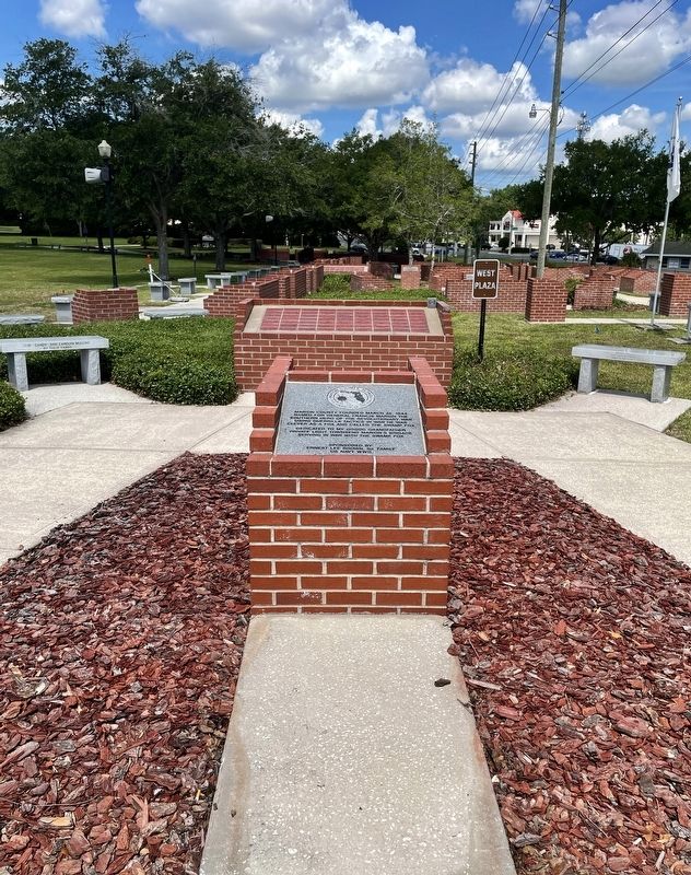
Near East Fort King Street 0.1 miles south of East Silver Springs Boulevard.
Marion County founded March 25, 1844. Named for General Francis Marion the southern hero of the Revolutionary War. Using guerrilla tactics in war he was clever as a fox and called the Swamp Fox.
Sponsored by: Ernest Lee Brown Sr. . . . — — Map (db m198430) HM WM
On County Road 314 3 miles south of State Route 40, on the left when traveling south. Reported missing.
A short distance north of here stood the sugar plantation of Jehu Foster Marshall, established in 1855. At the start of the Civil War in 1861, Marshall was named a colonel in the Confederate Army and soon commanded one of General Wade Hampton's . . . — — Map (db m167953) HM
Near Interstate 75 at milepost 346, 3.7 miles south of Southwest College Road (Florida Route 200), on the right when traveling south.
Nestled in Marion County, Silver Springs is America’s oldest commercial tourist attraction, first drawing steamboat tourists in the 1870s. Famous for inventing glass-bottom boats in 1878, it became Florida’s “first tourist attraction,” and a . . . — — Map (db m313203) HM
On Southeast 26th Terrace at Southeast Third Street, on the left when traveling south on Southeast 26th Terrace.
The Florida Industrial School for Girls (FISG) was the state’s first reform school for white girls aged 9-18. The legislature authorized the school, and it opened in a temporary facility in Ocala in 1915. Two years later, FISG moved to its . . . — — Map (db m263511) HM
On East Fort King Street at Southeast 39th Terrace, on the right when traveling west on East Fort King Street.
On a nearby knoll stood Fort King, important military outpost during the removal of the Florida Indians. Adjacent to a Seminole agency established in 1825, it was named for Col. William King and first occupied in 1827. Outside the stockade, on . . . — — Map (db m150855) HM
On East Silver Springs Boulevard (State Road 40) at Southeast 25th Avenue, on the right when traveling west on East Silver Springs Boulevard.
On May 1, 1908, the John J. Dickison Chapter of the United Daughters of the Confederacy (UDC) dedicated this monument to honor the Confederate dead. To erect the monument, the UDC collected $1,500 from its members, schoolchildren (donating pennies), . . . — — Map (db m90555) HM WM
On East Silver Springs Boulevard (State Road 40) at Southeast Magnolia Avenue, on the right when traveling east on East Silver Springs Boulevard.
Designated as a Public Square in the original Ocala plat of 1846, this location was the site of Marion County’s first permanent courthouse built in 1851. It was a two-story frame building of Colonial design. The second courthouse was erected on this . . . — — Map (db m90553) HM
Head, Heart, Hands, and Health
Florida 4-H began as a program to teach farming methods to rural youth and became a community-based program that taught millions of young Floridians how to Learn By Doing. In 1909, UF Dean of Agriculture J.J. . . . — — Map (db m135971) HM
On Desoto Park Drive at East Lafayette Street, on the right when traveling south on Desoto Park Drive.
John Martin was born in Plainfield, Marion County, Florida on June 21, 1884. He was admitted to the Florida Bar in 1914. He joined the Democratic Party and toured the state making speeches in support of President Woodrow Wilson before and during . . . — — Map (db m79523) HM
On County Road 225, on the right when traveling north.
Evinston Community Store and Post Office
The Evinston community store, originally a warehouse, was built of heart pine in 1884 by W.P. Shettleworth. it was bought by Joseph Wolfenden, who first operated it as a store. The post office, . . . — — Map (db m54240) HM
On Hastings Boulevard at Leonard Road, on the left when traveling south on Hastings Boulevard.
The Wetumpka Fruit Company, founded and headquartered in Boston, Massachusetts, became one of the largest agricultural businesses to plant citrus groves in St. Johns County. In 1881, George Waterman Leonard and his wife, Emma Jeanette Billings . . . — — Map (db m264432) HM
On North Church Street at Trinity Street, on the left when traveling north on North Church Street.
Trinity Episcopal Church is the oldest standing church in Abbeville. With its classic Gothic architecture and 125-foot steeple, it dominates the Abbeville skyline. Built by a congregation made prosperous by the economy of cotton in the antebellum . . . — — Map (db m11921) HM
Near Southeast 80th Street (County Road 328) at South Pine Avenue (U.S. 441), on the right when traveling east.
Explorer Ponce de Leon called the panhandle between the Atlantic and the Gulf of Mexico "La Florida" which means "the flowery place." What he saw was untamed wilderness. "Untamed" is a good indicator of the way green things grow here. What . . . — — Map (db m166912) HM
Dickison and His Men
John Jackson Dickison (1816-1902), Florida's famous Civil War guerrilla leader, bivouacked at Camp Baker, south of here, during the closing weeks of the conflict. Dickison and his men became legendary figures. As Company . . . — — Map (db m40315) HM
On County Road 40 1.1 miles west of U.S. 41, on the left when traveling west.
One block to the south is the site of the discovery of hard rock phosphate in Florida by Albertus Vogt in 1889. It made Dunnellon a boom town and first center of the industry. The Tiger Rag, Early Bird and Eagle mines were among the most valuable. . . . — — Map (db m67058) HM
Near East Fort King Street 0.1 miles south of East Silver Springs Boulevard.
Built near Silver Springs 1827 to protect the United States frontier in Florida and named after COL. William King, Civil Military Governor of west Florida. December 1835, General Wiley Thompson was killed near Fort King, diseases killed many . . . — — Map (db m198857) HM WM
Near East Fort King Street at SE 39th Avenue, on the left when traveling east.
Fort King was a typical U.S. Army frontier fort and a noteworthy symbol of the longest and costliest war America had with its native people - the Seminole War. Fort King is a narrative that speaks of a complicated history as relates to the . . . — — Map (db m201351) HM
On East Silver Springs Boulevard (State Road 40) at Southeast Osceola Avenue, on the right when traveling east on East Silver Springs Boulevard.
In 1539 Spanish explorers under Hernando de Soto discovered in this vicinity a populous native country called Ocali. From this Timucuan name is derived Ocala, a designation distinctive among the oldest place-names of Florida. Marion County, named . . . — — Map (db m90554) HM
Near Florida's Turnpike (Florida Route 91 at milepost 299), 5 miles south of U.S. 301.
Sumter County is home to one of the fastest-growing metro areas in the nation. Anchored by The Villages, a bustling master-planned retirement community, the area continues to attract the young and young at heart to North Central Florida. Known for . . . — — Map (db m313212) HM
Old Fort King Trail is near the original Fort King Road. During the Second Seminole War, Fort King Road served as the main transportation and communication route between Fort Brooke (Tampa) and the Seminole Agency at Fort King (Ocala). Following an . . . — — Map (db m126033) HM
Near Northeast 3rd Street just west of Northeast Sanchez Avenue, on the right when traveling west.
Marti City, the center of Ocala’s tobacco industry, was a Cuban community of cigar makers, located 2 miles S.S.W. of this park. The Cubans worked with tobacco leaves that came from Cuba to Ocala through Jacksonville. Twenty cigar factories were . . . — — Map (db m212100) HM
Near Southeast 80th Street (County Road 328) at South Pine Avenue (U.S. 441), on the right when traveling east.
History of Santos Founders and Families In 1882, John A. Cole and his family (black Americans) established Santos, naming it after a village in Brazil (South America) where they had gone to start a new life following the American Civil War. . . . — — Map (db m166911) HM
On County Road 468 2 miles east of U.S. 301, on the right when traveling east.
Sumter County was created by an act of the Florida Legislature on January 8, 1853. The new county was created from the southern part of Marion County and contained a large segment on what is now Lake County. The community of Adamsville was selected . . . — — Map (db m66858) HM
On U.S. 301 at County Road 522, on the right when traveling north on U.S. 301.
Sumter County was created by an act of the Florida Legislature on January 8, 1853. The new county was created from the southern part of Marion County and included a large segment of what is now Lake County. The community of Adamsville was selected . . . — — Map (db m66969) HM
On East Fort King Street 0.1 miles south of East Silver Springs Boulevard.
In Memory of Marion Counties Fallen
January 2001 - Present
Chad W Lake, Staff Sergeant, US Army, 02/2005 • Robert Blair, Specialist, US Army, 05/2006 • Daniel A Suplee, Staff Sergeant, US Army NG, 08/2006 • William Crow Jr, . . . — — Map (db m199081) WM
Near East Fort King Street 0.1 miles south of East Silver Springs Boulevard.
Captain John J. Dickison moved to Orange Lake (Marion County) and was a plantation owner. Served as 1st LT. in Marion Light Artillery. Later formed 2nd Florida Cavalry Co. H. commanding mostly less than 300 soldiers. Relied on guerrilla actions to . . . — — Map (db m199030) WM
Near East Fort King Street at SE 39th Terrace, on the left when traveling east.
The Second Fort
Amidst growing hostilities with the Seminole, the U.S. Army reconstructed Fort King in 1837 and continued its use until the termination of the war. Unlike the first fort, the second fort appears to have been constructed in . . . — — Map (db m201408) HM
The First Alabama Cavalry U.S. Army
Organized July 12, 1862 - Deactivated October 20, 1865
Huntsville, Alabama
Colonel George E. Spenser, Commander
Organized by special order No. 100 by Major General Don Carlos Buell of U.S. Army. Over . . . — — Map (db m80884) HM WM
On State Highway JJ 0.6 miles south of State Highway Z, on the right when traveling north.
The July 28, 1862, Battle of Moore's Mill opened about one-eighth mile south along the Moore's Mill-Galbreath Mill road, near today's State Road JJ. This area then was heavily timbered.
Lying in ambush east of the road were about 260 . . . — — Map (db m207957) HM
On Main Street (U.S. 41/64) at Mabee Avenue, on the right when traveling east on Main Street.
RyeMabee, 1930, Marion County, Tennessee, was placed on the National Register of Historic Places by the United States Department of the Interior in December, 1997. — — Map (db m194414) HM
Thin black lines indicate changes in relevance. Between each pair of lines entries are ordered geographically but all have the same relevance.
* Inflectional forms of words are their plurals, singulars, and possessives as well as gramatical tenses and similar variations.