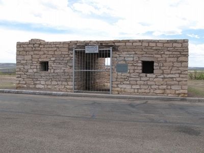
On Interstate 10 2 miles east of Farm to Market Road 2023, on the right when traveling east.
Replica of San Antonio and San Diego overland stage coach stop. This building was constructed of the stone from the original site which is ½ mile south-east of this location near Tunis Springs. The remains of a large Comanche Indian camp still . . . — — Map (db m73308) HM
On West James Street, on the left when traveling south.
(Front):
After Federal evacuation at start of Civil War, occupied by 2nd Regiment Texas Mounted Rifles. On far western frontier defense line. Supply post for troops going to and from Arizona-New Mexico campaign 1861-1862, designed to make . . . — — Map (db m63592) HM WM
On East Dickinson Boulevard (Business Interstate 10) 0.5 miles west of Interstate 10, on the right when traveling west.
Formed from Presidio County
Created May 3, 1871
Organized March 9, 1875
On March 9, 1875, the following
county officers were elected:
George M. Frazer, Chief Justice
Cesario Torres, Commissioner
Francis Rooney, Commissioner . . . — — Map (db m136354) HM
On South Main Street at West Callaghan Street, on the right when traveling south on South Main Street.
In 1875 Pecos County was officially organized and St. Gall, later named Fort Stockton, was designated as its seat of government. The current Pecos County Courthouse is the fourth since the county's founding. The first (1875) was officially . . . — — Map (db m186249) HM
Once, one of the largest artesian spring systems in Texas, called Comanche by early Mexican settlers, it provided 60 million gallons of water per day. Water that all relied upon; the Comanche, Apache, Kiowa, Kickapoo, mail coaches to El Paso and San . . . — — Map (db m201374) HM
Pecos County is the only county in Texas that is a top ten producer of renewable energy, oil, and natural gas. The first large utility grade wind farms in Texas were constructed in the Fort Stockton, Pecos County area in 2000/2001. The farms are . . . — — Map (db m201393) HM
On North Main Street at West 2nd Street, on the right when traveling south on North Main Street.
Built in 1912, this structure originally housed the First National Bank of Fort Stockton. Established two years earlier, the bank failed during the years of the great depression. In 1935 the building was purchased by the Pecos County State Bank. . . . — — Map (db m201446) HM
On North Rooney Street at East 1st Street, on the right when traveling north on North Rooney Street.
Kentucky native Oscar Waldo Williams (1853-1946) graduated from Harvard with a law degree in 1876 and moved to Texas in search of a drier climate. He worked as a land surveyor as the South Plains opened for settlement and in 1884 accepted a job as . . . — — Map (db m138961) HM
On South Main Street at West James Street, on the right when traveling south on South Main Street.
Zero Stone Park, located south of the Pecos County Courthouse, is the home of the "Zero Stone", which is the center of the plaza of St. Gall. All lots in St. Gall are referenced to this position. The date on the stone is 1847; however the stone was . . . — — Map (db m201471) HM
On Pecan Street 0.3 miles south of East Garfield Street (U.S. 277), on the right when traveling north.
Organized in 1885 from sections of Crockett, Kinney, and Pecos Counties, Val Verde County was named for a Civil War battle in New Mexico which involved Texas Confederate Forces. The growing railroad town of Del Rio was chosen as the seat of . . . — — Map (db m52678) HM
On North Main Street (Farm to Market Road 1053), on the right when traveling north.
Located in the petroleum-rich Permian Basin, Pecos is one of the most prolific oil-and gas-producing counties in Texas. The petroleum business here began about 1900 with the drilling of the Turney well near an ancient "seep", a traditional local . . . — — Map (db m138962) HM
On South Spring Street at South Rooney Street, on the left when traveling north on South Spring Street.
Built in 1878, Koehler's Store was a one-story masonry building. By 1884, the store had expanded to include a store, bank and saloon. The second floor was added in the 1930s as a WPA project. Today Pecos County owns the building and it serves as the . . . — — Map (db m201510) HM
On West Oak Street (U.S. 90) 0.2 miles east of U.S. 285, on the right when traveling east.
Formed from Pecos County
Created Organized
April 8,1905 September 19, 1905
Named in honor of
Alexander Watkins Terrell
1827-1912
A distinguished officer in the
Confederate Army
Member of the Texas Legislature . . . — — Map (db m138870) HM
Thin black lines indicate changes in relevance. Between each pair of lines entries are ordered geographically but all have the same relevance.
* Inflectional forms of words are their plurals, singulars, and possessives as well as gramatical tenses and similar variations.