41 entries match your criteria.
Former U.S. Presidents: #43 George W. Bush Historical Markers
By Mark Hilton, May 6, 2017
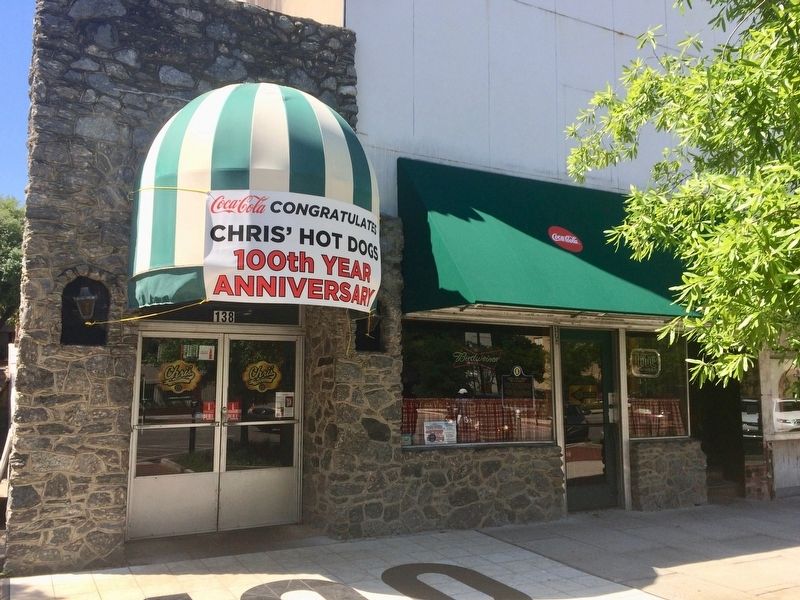
Chris’ Hot Dogs restaurant
| 1 ► Alabama, Montgomery County, Montgomery — Chris’ Hot Dogs — Established In 1917 — |
| On Dexter Avenue east of South Perry Street, on the right when traveling east. | |||
| 2 ► Alabama, Montgomery County, Montgomery — Rosa Parks Returns to St. Paul AME / Rosa Parks's Faith Guided Her Life — |
| On East Patton Avenue at Wesley Drive, on the right when traveling east on East Patton Avenue. | |||
| 3 ► Arkansas, Benton County, Bella Vista — Operation Iraqi Freedom — |
| 4 ► Arkansas, Benton County, Bella Vista — United States Commanders in Chief — |
| 5 ► Colorado, Broomfield County, Broomfield — 911 Memorial — |
| Near Spader Way at Community Park Road, on the left when traveling north. | |||
| 6 ► Delaware, Kent County, Dover, Dover Air Force Base — VC-9C — S/N 73-1682 — |
| Near Heritage Road, 0.7 miles west of Bayside Drive (Delaware Route 9), on the left when traveling west. | |||
| 7 ► District of Columbia, Washington, Northwest Washington, Burleith — Famous Burleith Residents — |
| On T Street Northwest at 37th Street Northwest, on the right when traveling west on T Street Northwest. | |||
| 8 ► District of Columbia, Washington, Southwest Washington, Southwest Waterfront — Dr. Dorothy Height — |
| On 7th Street Southwest south of G Street Southwest, on the left when traveling south. | |||
| 9 ► Florida, Brevard County, Mims — Thurgood Marshall — Harry T. & Harriette V. Moore Memorial Park — |
| Near Freedom Avenue, 0.3 miles south of Parker Street, on the left when traveling south. | |||
| 10 ► Florida, Hillsborough County, Tampa — Gen. Norman Schwarzkopf — 8/22/1934 - 12/27/2012 — |
| Near U.S. 301, 0.2 miles south of East Dr. Martin Luther King Jr. Boulevard, on the right when traveling south. | |||
| 11 ► Georgia, Bryan County, Richmond Hill — Richmond Hill Veterans Monument — In God We Trust — |
| Near Cedar Street, 0.1 miles north of Richard Davis Drive, on the right when traveling north. | |||
| 12 ► Indiana, Allen County, New Haven — Veterans Memorial — |
| On Park Avenue east of Broadway Street, on the right when traveling east. | |||
| 13 ► Indiana, Marion County, Indianapolis, Mile Square — 9/11 Memorial — |
| On Senate Avenue north of West Washington Street, on the right when traveling north. | |||
| 14 ► Indiana, Steuben County, Angola — Tri-State College 9-11 Memorial — |
| Near South Darling Street at West South Street, on the left when traveling north. | |||
| 15 ► Kansas, Leavenworth County, Fort Leavenworth — General Colin L. Powell — American Statesman • American Son • American Soldier — |
| On Grant Avenue near Smith Lake, on the right when traveling north. | |||
| 16 ► Kentucky, Fayette County, Lexington — William S. Farish — 1939 - — |
| Near East Main Street (U.S. 60) at Midland Avenue (U.S. 60), on the right when traveling west. | |||
| 17 ► Louisiana, Ascension Parish, Gonzales — The Persian Gulf War — August 2, 1990-February 28, 1991 — |
| Near South Irma Boulevard, 0.3 miles north of East Worthey Street, on the right when traveling north. | |||
| 18 ► Louisiana, Ascension Parish, Gonzales — The War on Terror: The Afghanistan War And The Iraq War — |
| Near South Irma Boulevard, 0.3 miles north of East Worthey Street, on the right when traveling north. | |||
| 19 ► Louisiana, Ascension Parish, Gonzales — War on Terror: The Iraq War — (Operation Iraqi Freedom) — |
| Near South Irma Boulevard, 0.3 miles north of East Worthey Street, on the right when traveling north. | |||
| 20 ► Louisiana, Caddo Parish, Shreveport, Downtown Riverfront — W — Released 2008 — Film Location — |
| On Common Street (Louisiana Route 3036) at Cotton Street, on the right when traveling north on Common Street. | |||
| 21 ► Louisiana, Pointe Coupee Parish, Lettsworth — Birthplace of Buddy Guy — Lettsworth, Louisiana 70752 — |
| On State Highway 1, 0.7 miles north of 971, on the left when traveling north. | |||
| 22 ► Maryland, Anne Arundel County, Annapolis, Naval Academy — Evoking Our Naval Heritage Past — Sailing Confidently Into The Future — |
| Near Taylor Avenue (Maryland Route 435) north of Melrose Street, on the right when traveling south. | |||
| 23 ► Massachusetts, Bristol County, Fall River — Battleship Cove 9-11 Memorial — |
| On Water Street, on the right when traveling west. | |||
| 24 ► Minnesota, Hennepin County, Mound — 9/11 Memorial — |
| On Commerce Boulevard (County Road 110) 0.4 miles south of Lynwood Boulevard (County Road 15), on the right when traveling south. | |||
| 25 ► Mississippi, Simpson County, Mendenhall — Mendenhall — Simpson County Heritage Trail — |
| On Court Avenue at Main Street North, on the right when traveling east on Court Avenue. | |||
| 26 ► Missouri, Cass County, Pleasant Hill — Defenders of Freedom Veterans Memorial — "Some Gave All, All Gave Some" — |
| On Veterans Parkway (AKA Lake Street) at Locust Street, in the median on Veterans Parkway (AKA Lake Street). | |||
| 27 ► Missouri, Pettis County, Sedalia — Coliseum — 1906 — Architect: Thomas Bast • Contractor: T. H. Johnson — |
| 28 ► Missouri, St. Louis, Downtown — Presidential First Pitch — April 5, 2004 — Greatest Moments — |
| On South Broadway south of Spruce Street, on the right when traveling south. | |||
| 29 ► Ohio, Franklin County, Columbus, Franklinton — 41-25 — Green Lawn Cemetery — |
| On Greenlawn Avenue, in the median. | |||
| 30 ► Ohio, Shelby County, Sidney — George W. Bush — A Visit to the SPOT Restaurant — |
| On Court Street (Ohio Route 29) at Ohio Avenue (Ohio Route 47), on the left when traveling west on Court Street. | |||
| 31 ► Pennsylvania, Delaware County, Glen Mills, Concord Township — Limited Military Involvement / War on Terror — Concord Township American Hero Memorial — Honor • Remembrance • Courage • Fortitude — |
| On Smithbridge Road east of Bob Mench Drive, on the left when traveling east. | |||
| 32 ► Pennsylvania, Lackawanna County, Scranton — The Honorable George W. Bush — |
| 33 ► Pennsylvania, Lawrence County, Wampum — On August 4, 2000 — |
| Near Wampum-New Castle Road at Clyde Street. | |||
| 34 ► Pennsylvania, Somerset County, Indian Lake, Stonycreek Township — Flight 93 Temporary Memorial — |
| On Skyline Road, 0.9 miles east of Lambertsville Road, on the right when traveling east. | |||
| 35 ► Texas, Andrews County, Andrews — Fight Against Terrorism — Andrews County Veterans Memorial — |
| On West Broadway Street at NW 6th Street, on the right when traveling west on West Broadway Street. | |||
| 36 ► Texas, Lamar County, Paris — Global War on Terror — Sept. 11, 2001 — |
| Near South Collegiate Drive north of Jefferson Road (County Road 1507), on the right when traveling north. | |||
| 37 ► Texas, McLennan County, Crawford — 13191 — Crawford — |
| On North Lone Star Parkway (State Highway 317) at 5th Street (County Route 185), on the right when traveling north on North Lone Star Parkway. | |||
| 38 ► Texas, Midland County, Midland — 13058 — George Bush Family Home — |
| On North H Street north of West Ohio Avenue, on the right when traveling north. | |||
| 39 ► Texas, Midland County, Midland — 15411 — George W. Bush Childhood Home — |
| On West Ohio Street at North H Street, on the right when traveling west on West Ohio Street. | |||
| 40 ► Virginia, Arlington County, Arlington, The Pentagon — Pentagon Memorial — |
| 41 ► Virginia, Fairfax County, Idylwood — We will never forget. — |
| On West Street (Virginia Route 705) at U.S. 29, on the right when traveling south on West Street. | |||