On Ingraham Hill Road south of Foland Road, on the right when traveling south.
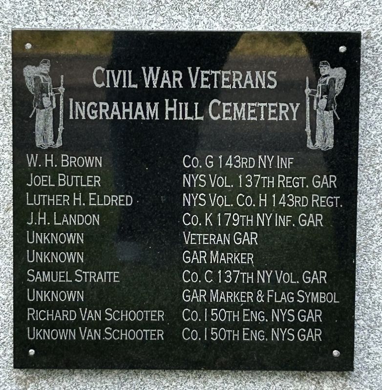
Civil War Veterans Ingraham Hill Cemetery
W.H. Brown Co. G 143rd NY Inf. • Joel Butler NYS Vol. 137th Regt. GAR • Luther H. Eldred NYS Vol. Co. H 143rd Regt. • J. H. Landon Co. K 179th Inf. GAR • Unknown Veteran GAR • Unknown GAR Marker . . . — — Map (db m255368) WM
The lone survivor of a lynching, Cameron dedicated
his life to promoting civil rights, racial unity
and equality. He was an author and founded several
chapters of the NAACP and also
America's Black Holocaust Museum in Milwaukee.
"I . . . — — Map (db m197940) HM
Was part of the Southern Christian Leadership
Conference, founded by Martin Luther King, Jr.
whose purpose was to harness moral authority in the
service of the civil rights movement.
"If my mind can conceive it, and my heart can . . . — — Map (db m197877) HM
The 35th President of the U.S., Kennedy supported
desegregation and civil rights. He proposed
what became the Civil Rights Act of 1964.
"One person can make a difference and
every person should try." — — Map (db m197905) HM
Became a Freedom Rider associated with the
Student Nonviolent Coordinating Committee.
Later, as the chairman of SNCC, he helped plan
and took part in the Selma, Alabama desegreation
march that became known as Bloody Sunday.
"We can . . . — — Map (db m197888) HM
On Collier Street 0.1 miles south of Court Street (U.S. 11), on the left when traveling south.
Dedicated to all veterans who served our country during the Korean Conflict, "The Forgotten War", July 25, 1950 - July 27, 1953 [south side] Korean (conflict) War. June 25, 1950 - July 27, 1953. Killed in action, Broome County, NY. Patrick . . . — — Map (db m198173) WM
On Lewis Street 0.1 miles east of Chenango Street, on the left when traveling east.
Erected November 1913 by Guglielmo Marconi to test the possibility of transmitting telegraphic signals to moving trains along the Lackawanna RR. — — Map (db m198200) HM
On Riverside Drive at Water Street, on the right when traveling west on Riverside Drive.
Men of Broome who served for us, in your name this bridge we give, that your laurels may grow green, that your memory may live. Flowing stream and wooded hills spanned by arch of classic grace, here we speak our gratitude, here we hold your . . . — — Map (db m198130) WM
Devoted his life to the pursuit of social justice
through non-violent civil disobedience,
beginning in South Africa, then as a leader of the
independence movement in his native India.
He was assassinated as he tried to address the . . . — — Map (db m197899) HM
Near This Point 18 August 1779
Camped the army of James Clinton en
route to join the forces of General John
Sullivan in the expedition against the Iroquois and their British allies in the war of
the American Revolution
Originally erected by . . . — — Map (db m92920) HM
Imprisoned for resisting South African apartheid.
Four years after his 1990 release, South Africans
of all races were allowed to vote for the first time
in a national election where he was elected the
first black president of South . . . — — Map (db m197904) HM
On Century Drive north of Kriska Lane, on the left when traveling north.
First hospital on the United States dedicated to the treatmemt of alcoholism.
Placed by the New York State Society of the National Society of the Dames of the Court of Honor
Mrs. James V. Fiori
State President
1997 — — Map (db m149561) HM
On Court Street, on the right when traveling west.
Phelps Mansion Museum
has been placed on the
National Register of
Historic Places 1973
by the United States
Department of the Interior — — Map (db m92921) HM
Indians and other Americans
removed from former burial
ground on the west bank
of the Chenango River
5 miles north of its
confluence with the
Susquehanna River
1972 — — Map (db m256783) HM
A museum exhibit interprets the Sullivan-Clinton Campaign of 1779. The campaign destroyed Native American villages and crops throughout the Iroquois homeland. — — Map (db m94628) HM
Routes of the Armies of General John Sullivan and General James Clinton 1779
An expedition against the hostile Indian nations which checked the aggressions of the English and Indians on the frontiers of New York and Pennsylvania, extending . . . — — Map (db m93324) HM
On Exchange Street at Court Street (U.S. 11), on the right when traveling north on Exchange Street.
Security Mutual
Building — 1904
T. I. Lacey & Son - Architect
Designated an historic landmark
by the Binghamton Commission on
Architecture & Urban Design — — Map (db m248287) HM
Broome Co. specialty as early as 1938, skewered chunks of marinated meat, charbroiled & served on bread. Celebrated at “Spiedie Fest” starting 1983. — — Map (db m298041) HM
Near True Street east of Glenwood Avenue, on the left when traveling east.
St Michael’s
Greek Catholic Church Cemetery
Historical Plaque
1907 - 1936
Our forefathers buried their dead by horse and buggy on the negotiated 1907 right of way with Glenwood Cemetery Association. We have two right of ways through Glenwood . . . — — Map (db m253483) HM
On Chestnut Street at College Street, on the right when traveling south on Chestnut Street.
Former site of St. Mary's Home operated by the sisters of St. Joseph of Carondelet founded by the Rev. James F. Horrigan 1881 - 1961. Erected by the kids, benefactors of St. Mary's Home Aug. 1998. — — Map (db m198202) HM
St. Michael’s
World War II Memorial
In Memory of Veterans
of World War II. Stalwart
Defenders of Lasting
Peace for Freedom and
our American way of
life.
Въ памѧть . . . — — Map (db m253474) HM
A woman's right activist whose protests
ultimately led to the passage of the Nineteenth
Amendment to the Constitution which gave
women the right to vote.
"Failure is impossible" — — Map (db m197893) HM
Built by Cornelius & Barbara Bevier circa 1850. Purchased 1889 by Otsego County native & Civil War veteran William Wright for 3,000.00. W. E. Wright was a carpenter, general contractor & proprietor of two stove & tinware stores in Binghamton. . . . — — Map (db m94390) HM
On Wall Street at Dwight Street, on the right when traveling south on Wall Street.
The Binghamton Clothing Company stood directly across the street from this marker. The fire, which began on July 22, 1913 at approximately 2:25pm, remains the worst loss of life by fire in city history. The fire claimed 31 lives. Nellie Connor, . . . — — Map (db m198174) HM
First Farm Bureau in the United States
In 1911 began the largest organization of farmers founded for the purpose of extending the science of agriculture.The growth of their idea resulted in the unparalleled productivity of American agriculture . . . — — Map (db m93291) HM
On Main Street (New York State Route 17C) at Oak Street, on the left when traveling east on Main Street.
Trinity Memorial Episcopal Church has been placed on the National Register of Historic Places in 1998 by the United States Department of the Interior. — — Map (db m198201) HM
Became a civil rights activist and participated in
the Selma Alabama march after Bloody Sunday,
and was murdered later that day by the
Ku Klux Klan.
"Everybody's struggle" — — Map (db m197883) HM
A white mail carrier who staged lone protests
against racial inequality by hand-delivering letters
he had written denouncing racial segregation.
He was gunned down on his final walk to
the state capital in Mississippi.
"Equal rights . . . — — Map (db m197891) HM
On Henry Street at Chenango Street, on the right when traveling west on Henry Street.
William L. Moore was a man of action. This Binghamton native faced many challenges while helping to preserve the freedom and rights of others. After he served our country honorably as a U.S. Marine and graduated from Harpur College (SUNY), he . . . — — Map (db m198184) HM
On Hawley Street at Centenary Street, on the left when traveling west on Hawley Street.
In the streets nearby before the Civil War and after arose a vibrant African American community of property owners, pastors and educators who helped formerly enslaved runaways seek freedom in the city or gave them support for their travels. Black . . . — — Map (db m258018) HM
On Carroll Street at Lisle Avenue, on the right when traveling north on Carroll Street.
The A.M.E. Zion Church, now known as Trinity A.M.E. Zion at 203 Oak St., served as a place of worship and a safehouse for runaway slaves. The church was founded by Rev. Henry Johnson and others in 1838. Rev. Jermain Wesley Loguen, director of the . . . — — Map (db m258019) HM
On Court Street (U.S. 11) at Collier Street, on the right when traveling east on Court Street.
Binghamton was an important hub of anti-slavery and women's rights conventions and debates. Brigham Hall hosted in September 1857 one of several conventions organized by the Anti-Slavery Society in Western and Central New York. Activists like A. . . . — — Map (db m303526) HM
On Henry Street at Fayette Street, on the right when traveling west on Henry Street.
Bud Fowler played for the Binghamton Bingos in 1887 amid rampant segregation. Fowler was one of the first players to integrate a professional baseball team before Jackie Robinson integrated the Brooklyn Dodgers in 1947 and helped usher in the civil . . . — — Map (db m252208) HM
On Henry Street at Washington Street, on the left when traveling west on Henry Street.
Christ Church
(Episcopal)
Organized 1810
Built 1853
has been placed on
National Register of
Historic Places
by the United States Department of the Interior — — Map (db m257848) HM
On Collier Street at Court Street, on the right when traveling north on Collier Street.
Christopher Columbus
"Vir ligur atque italicus"
Explorer and navigator
Discoverer of America
Herald
of the journey to our land
of millions of people
of
all races, creed and nationality
Broome County
Quincentennial Committee . . . — — Map (db m256031) HM
On Main Street at Front Street (U.S. 11), on the right when traveling west on Main Street.
Church Building Dedicated
Aug. 17, 1869
[Bell inscription reads]
"To show forth thy loving-kindness in the morning
and thy faithfulness, every night." — — Map (db m283037) HM
On Court Street (U.S. 11) west of Fayette Street, on the right when traveling west.
Former Black Civil War veteran, Andrew Jackson, worked for the Phelps family and helped to preserve and maintain this stately property until it was sold in 1888. He came to Binghamton from Georgia after the war during which he was a "body . . . — — Map (db m256033) HM
On Jay Street just north of Hawley Street, on the right when traveling north.
Before the enslaved population gained their freedom in the American south, the City of Binghamton had a school for Black children established in 1861. In this way Binghamton was an early pioneer in the education of Black youth. The school was . . . — — Map (db m258020) HM
On Henry Street at Washington Street, on the right when traveling east on Henry Street.
Major Olmsted reported to the Binghamton Press in 1910 how his father and mother were active agents of the Underground Railroad and how their house was used to provide refuge for those who were passing through Binghamton. Olmsted described one . . . — — Map (db m257849) HM
On Court Street west of Water Street, on the right when traveling west.
Welcome to Binghamton
A lovely place to visit, a great place to live!
Nestled within the wooded hills of the Susquehanna River Valley Binghamton has one of the most affordable housing markets in the country as the city offers a wealth . . . — — Map (db m249020) HM
On Conklin Avenue at High Street, on the right when traveling west on Conklin Avenue.
At 6:30 PM on Steptember 28, 1975, a Crowley Foods worker saw two youths launching a rubber raft from the shore of the Susquehanna River. He hurried to the nearest telephone to call the Binghamton Fire Department, but before his call went through, . . . — — Map (db m263202) HM
On New York State Route 79 just north of Old Route 79, on the right when traveling west.
Ancient river crossing and settlement. Native peoples traveled here to trade, to hunt, and to live near the Chenango and Tioughnioga. — — Map (db m296070) HM
The stone walls visible here are parts of Lock 107 on the Chenango Canal, which opened in 1837. Constructed as a composite lock of stone lined with wooden planks, Lock 107 was repaired and rebuilt several times over the years. The last rebuild of . . . — — Map (db m94370) HM
The Chenango Canal was part of a vast network of canals that connected New York State's cities with the Great Lakes, the Hudson River and the Atlantic Ocean. Opened for navigation on May 6, 1837, the Chenango Canal carried people between the Erie . . . — — Map (db m296124) HM
On Welton Street at Maple Street, on the right when traveling north on Welton Street.
Last vacant school in town. Became community center 1940. Moved from Doraville in 2 parts 3 1/2 miles in 1993. Restored to mid-1800's. — — Map (db m252007) HM
On Maple Street, on the right when traveling south.
Women's Episcopal Seminary
Female enrollment of twenty
Gothic Revival built 1857
with tower and bell Sold in 1890 Burned in 1977 — — Map (db m252008) HM
On New York State Route 7 at Nineveh Bridge, on the left when traveling north on New York State Route 7.
Oldest library in Broome Co
Est 1901 with support from
the Hobbs Bros. New bldg
funded 1971 - Emma Brown in
memory of Elma Blackmore. — — Map (db m251466) HM
On Tunnel Road at Villecco Road, on the right when traveling south on Tunnel Road.
Train tunnel built 1853-1868.
1869 battle between Erie RR
& Albany Susquehanna RR
Engines collided. No deaths.
A&S won and later became D&H RR — — Map (db m252489) HM
The valleys of the Upper Susquehanna River were natural routes for Indians, traders and settlers. Oquaga, near Windsor, was an Indian fur-trading post, and became an objective of the Sullivan-Clinton Campaign of 1779. From a dam at the outlet of . . . — — Map (db m35164) HM
On Second Street, on the right when traveling west.
Set apart from Ulster and
Otsego Cos., 1797; Named
for Delaware River, which
was named for Lord Delaware,
Governor of Virginia, 1609 — — Map (db m92745) HM
On Second Street, on the right when traveling west.
This Boulder Marks The
Fort Stanwix Treaty Line
The deed from the Indians to the whites
was signed November,5 1768
The line was run in 1769
from the Delaware River almost due north
to the mouth of the Unadilla River
It afterward became the . . . — — Map (db m92769) HM
On Main Street, on the right when traveling south.
Historical Marker
Village of Deposit Incorporated 1811
Originally Cookhouse Site of John Hulce's home
First permanent settler 1789 — — Map (db m93293) HM
On East Main Street (New York State Route 17C) at Jefferson Avenue, on the right when traveling east on East Main Street.
His heart and hands built a great industry - A monument to his faith in the working man and all humanity.
The hope of the world lies in the evolution, progress and constant improvement and we look with confidence into that future rapidly . . . — — Map (db m281328) HM
On East Edwards Street at Mersereau Avenue, on the right when traveling east on East Edwards Street.
Mercereau Park
Part of the Old Village of
Union
Donated by
Mrs. Edward K. Mercereau
In the Year 1930
To Perpetuate
The Memory of
Union’s First Settlers — — Map (db m255373) HM
On Washington Avenue, on the left when traveling east.
This marker commemorates the men and women who achieved American independence. These Patriots, believing in the
noble cause of liberty, fought valiantly to found of new nation.
1775 - 1783 — — Map (db m281270) WM
On Vestal Street at South Street, on the right when traveling south on Vestal Street.
Est. 1792
Burial place of early settlers
and Joshua & John Mersereau,
heroes of the Revolutionary War
NYS & National Register of Historic Places — — Map (db m141694) HM
On West Main Street (Route 17C) at Badger Avenue, on the right when traveling west on West Main Street.
An expedition against the hostile Indian nations which checked the aggressions of English and Indians on the frontiers of New York and Pennsylvania, extending westward the dominion of the United States.
Union near this point the . . . — — Map (db m297935) HM
On West Main Street (New York State Route 17C), on the right when traveling west.
Built 1829-30 by C.E. and W.H. Keeler. Second store in Union Corners. Now oldest. Slated for demolition, but saved and restored 1987. — — Map (db m141708) HM
On River Road just west of Annabelle Street, on the right when traveling west.
Patterson-Hooper Cemetery. Burials as early ca. 1800. Amos Patterson 1749-1817, Revolutionary War Veteran. Served in MA militia — — Map (db m255347) HM
On County Road 49, on the left when traveling south.
War loves to prey upon the young.
Sophocles 450 B.C.
Students of Maine-Endwell Schools Killed
In The Vietnam War
Tom Gregory • Howard Snitchler • Jerry Zimmer • Pat O’Brien • Craig Swagler
Older men declare war. But it is the . . . — — Map (db m297149) WM
On River Road north of Annabelle Street, on the left when traveling north.
Erected in 1799 by Amos and Ann Patterson. It became a haven for river travelers, stage stop, and in 1842 was used as a temperance inn. — — Map (db m255306) HM
On River Road south of Annabelle Street, on the left when traveling north.
Patterson-Hooper Family Cemetery has been placed on the National Historic Register of historic places in 2008 by the United States Department of the Interior. — — Map (db m255313) HM
First President of the Endwell Rotary Club
whose vision and dedication were in large measure
responsible for the creation of Highland Park — — Map (db m283013) HM
A Friend to Everyone
A Best Friend to Highland Park
With his mind he planned it,
with his hands he built it,
and with his heart he touched it. — — Map (db m283014) HM
[Honored Dead]
Raymond E. Abbey • Robert L. Agan • Walter T. Alestek • Forrest K. Ames • Forrest M. Baldwin • Gerald C. Beach • William H. Broadley • George R. Bryan • Clarke F. Clemons • Harold P. Corey • Robert J. Cotanche • Arthur B. . . . — — Map (db m283030) WM
This memorial was originally located on the grounds of the former IBM Country Club site at 4301 Watson Blvd, Johnson City, NY. On January 9, 2004, IBM Corporation sold that property. Due to the significance of this Memorial, which is a symbol to . . . — — Map (db m283025) HM WM
On August 16, 1947, the employees of IBM Plant #1 paused
to pay tribute to their 57 fellow employees who made the supreme
sacrifice in the service of their country during the years of 1941-1946.
Originally unveiled by Mr. Thomas J. Watson, . . . — — Map (db m283027) HM
Honoring those who served
and in memoriam W.W.2
Douglas E. Baker - Merwin H. Cook
Ivan R. Lee - Paul H. McQueen
George Pado - Joseph Salata
Howard R. Thomas — — Map (db m283015) WM
1823 entries matched your criteria. Entries 101 through 200 are listed above. ⊲ Previous 100 — Next 100 ⊳