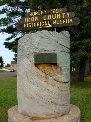
This 5 ½ foot diameter drill core came from the Cary Mine shaft from a depth of 2400 feet below the surface. The shaft was drilled during the period 1942-44 from surface to the 31st level and was later enlarged to its full size of 13X21 feet. . . . — — Map (db m36838) HM
Children are the innocent victims of adult hatred, ignorance, and bigotry.
During the Holocaust, 1939-1945, 1.5 million Jewish children were murdered.
No child should ever be a victim again.
"How can a person not be moved . . . — — Map (db m258452) WM
On Manitowish Road at U.S. 51, on the right when traveling north on Manitowish Road.
Main streets developed at the cross roads of resources, transportation, and people. The town of Manitowish grew up on timber and the railroad.
By the turn of the century, the “inexhaustible” stands of white pine had been cut from . . . — — Map (db m45527) HM
On U.S. 51 at Moose Lake Road, on the right when traveling south on U.S. 51.
You are now standing on the “Continental Divide”, a geological demarcation line which splits Northern Wisconsin.
North of “The Divide”, rivers flow to Lake Superior and finally to the Atlantic Ocean. These waterways are . . . — — Map (db m46685) HM
On Railroad Street at Lakeview Avenue, on the right when traveling north on Railroad Street.
The arrival of the Milwaukee, Lake Shore and Western Railroad in 1889 was a major factor in the economic development of Mercer’s isolated logging settlement. Timber and other natural resources could now be shipped year ‘round to markets. Much needed . . . — — Map (db m45098) HM
Near Turtle Flambeau Dam Road 0.5 miles east of County Route FF, on the right when traveling north.
The Turtle Flambeau Flowage was born in 1926, when the Chippewa and Flambeau Improvement Company built a dam on the Flambeau River, downstream from its confluence with the Turtle River improving its usefulness for power-generating and papermaking . . . — — Map (db m59475) HM
On County Highway J at County Highway H, on the right when traveling east on County Highway J.
For centuries Native Americans and voyagers using the Flambeau Trail carried their birch bark canoes and cargo across the wide “plain” where you are standing, between Echo Lake (called Big Turtle Lake) and Grand Portage Lake (Little . . . — — Map (db m45097) HM
In days of yesteryear, traveling south on the Flambeau Trail, you arrived at Big Turtle Lake (now Echo Lake) and Little Turtle Lake (now called either Grand Portage Lake or Tank Lake) to what is now Mercer. At Echo Lake you had a choice depending on . . . — — Map (db m46687) HM
On County Route FF 0.5 miles north of Turtle Flambeau Dam Road, on the right when traveling north.
America saw the vast forests of the Great lakes as an endless supply of the timber needed to settle the west. Farmers, factories and mills needed wood for fuel and building materials.
Men came to the northern forests to make their fortunes . . . — — Map (db m59479) HM
The felling of Iron County’s great stands of timber began in the late 1870’s. The white pine was the first to be cut. Down the Turtle River and over Lake of the Falls, buoyant pine logs were floated to sawmills further south.
Spring, when the . . . — — Map (db m46688) HM
On County Route FF 0.5 miles north of Turtle Flambeau Dam Road, on the right when traveling north.
The railroad pushed into northern Wisconsin in the 1870s, opening the deep forests for harvest. Now hardwoods such as maple, oak, spruce, cedar, balsam, birch and aspen could be cut.
More logs could be shipped by rail than by water so more men . . . — — Map (db m59480) HM
On County Route FF 0.5 miles north of Turtle Flambeau Dam Road, on the right when traveling north.
This camp was Carl Nelson’s headquarters camp. From this camp, he directed the woods operations and sent rail cars of timber south to the main line at Camp 8.
While all of the buildings are gone, artifacts found at the site tell a story of what . . . — — Map (db m59481) HM
On County Route FF 0.5 miles north of Turtle Flambeau Dam Road, on the right when traveling north.
Large, heavy cable remains from the pulley system (called a jammer), used to load the logs from the landing into the rail cars. Stove parts, railroad ties, a wash tub and glass bottles suggest a long term camp with railroad connections. . . . — — Map (db m59482) HM
On County Route FF 0.5 miles north of Turtle Flambeau Dam Road, on the right when traveling north.
William Henry Roddis realized that a fortune could be made in the woods.
In 1903, he purchased a parcel of land to build a mill in Park Falls. Roddis bought 35,000 acres of timber land in Iron and Ashland counties from Wisconsin Central . . . — — Map (db m59477) HM
On County Route FF 0.5 miles north of Turtle Flambeau Dam Poad, on the right when traveling north.
In 1925, the Roddis company contracted with Carl Nelson, a jobber, to run the camps. Between 1925 and 1930, he chose the camp sites, bought supplies and delivered timber to the log landings.
From 1930 until the company abandoned logging in . . . — — Map (db m59478) HM
On Turtle Flambeau Dam Road 0.5 miles east of County Route FF, on the left when traveling east.
In 1925, the Chippewa and Flambeau Improvement Company began construction on a dam to create a water reservoir for hydroelectric power, where the Turtle, Manitowish, and Flambeau rivers join.
The Roddis company owned land in the area, which . . . — — Map (db m59476) HM
On Wisconsin Avenue (State Highway 77) at Elm Street, on the right when traveling west on Wisconsin Avenue.
You are standing on the ancient Flambeau Trail, an important route for commerce for Native Americans, voyagers, and explorers travelling between settlements at LaPointe on Madeline Island and Lac du Flambeau 90 miles to the south.
Until railroads . . . — — Map (db m45096) HM
On Wisconsin Avenue (State Highway 77) at Plant Street, on the right when traveling west on Wisconsin Avenue.
The son of Irish immigrant parents was born in New York July 5, 1882. After graduating from the U. of New York he ventured to Montreal in 1906 when the town and iron ore mining were in their infancies. He served as a teacher and Principal at the OLD . . . — — Map (db m40933) HM
On Wisconsin Route 77, on the right when traveling east. Reported missing.
1884 … The rush was on to discover “red gold” on the Penokee Range! Speculators, miners and immigrants flocked to this area seeking their fortune in iron ore. Established as a small open pit mine in 1885 by the Oglebay-Norton Mining . . . — — Map (db m45158) HM
On Montreal Street at Wisconsin Avenue ( Highway 77), on the left when traveling south on Montreal Street.
Neat white frame houses, gently curving streets, and gracious landscaping mark the City of Montreal – the only planned mining company town in Wisconsin.
In 1921 the Oglebay-Norton Mining Company designed a community that would provide an . . . — — Map (db m45408) HM
On Kokogan Street at Mellen Street, on the right when traveling south on Kokogan Street.
Mining Upside Down
The large tailing piles across the river from Gile Falls are waste rock left from its mining at the Montreal Mine #5 Shaft.
The Montreal Mine’s vertical shaft extended to the depth of nearly one mile underground. Like . . . — — Map (db m46689) HM
On Montreal Street at Wisconsin Ave ( Highway 77) when traveling south on Montreal Street.
You are standing in the architectural complex that supported iron mining at the Montreal Mine #5 Shaft – the heart of the mining community known as “Montreal Location.”
The huge native field stone building served as the . . . — — Map (db m45411) HM
On Wisconsin Avenue (State Highway 77) at Plant Street, on the right when traveling west on Wisconsin Avenue.
The City of Montreal, incorporated in 1924, known for a short time as the Village of Hamilton, is a combination of the communities of Montreal and Gile.
Gile, on the river, was the center of the area’s timber industries. The largest, the . . . — — Map (db m40932) HM
Along this trail are the “ruins” of the buildings that made up the Plummer Mine Location. Each structure had a special function.
Steam power, created at the boiler House, turned the Hoisting Engine. In the early 1920’s, electricity . . . — — Map (db m45417) HM
Plummer Mine Headframe Interpretive Park
Dedicated to the iron miners and their families who helped build the Penokee Iron Range — — Map (db m45418) HM
Between 1 to 1 1/2 million years ago sediments of slate and cherty iron carbonates were laid down on top of the granite and greenstone bedrock covering this area. Molten lava flowed over the land, seeping into the great cracks on the surface . . . — — Map (db m45414) HM
On U.S. 2 at Cemetery Road, on the left when traveling east on U.S. 2.
Apostle Islands Scenic View
You are looking out over the Chequamegon Bay region and Apostle Islands which comprises 22 Islands that form an archipelago about 30 miles long and 18 miles wide.
All except one of the Islands (Long Island) are . . . — — Map (db m125029) HM
Near County Road A 2 miles north of State Route 122. Reported missing.
The most popular gateway to the Flambeau Trail started here, on the shore of Oronto Bay. Also known as the “Montreal River Trail”, it was the only route inland into the dense virgin forest until the late 1880’s.
The Trail was an . . . — — Map (db m45095) HM
On State Highway 182 7 miles west of State Highway 47-182, on the right when traveling east.
"An old Indian legend says that Bearskull Lake is sacred. Any white man who had anything to do with the lake or its vicinity will have everlasting ill fortune."
In 1904, a tornado ripped through this area, toppling the last great stands . . . — — Map (db m59484) HM
129 entries matched your criteria. Entries 101 through 129 are listed above. ⊲ Previous 100