132 entries match your criteria. Entries 101 through 132 are listed.⊲ Previous 100
New Hampshire Historical Highway Markers
Marker series sponsored by the NH Division of Historical Resources and NH Department of Transportation (green background, white lettering, with the multi-colored state seal on top).
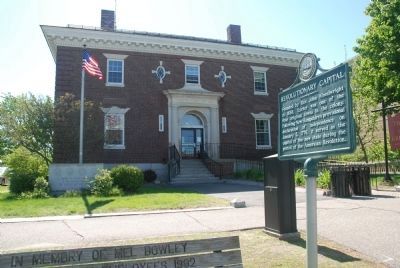
Founded by Rev. John Wheelwright in 1638, Exeter was one of the four original towns in the colony. Following New Hampshire’s provisional declaration of independence on January 5, 1776, it served as the capital of the new state during the period of . . . — — Map (db m75244) HM
On his way to Portsmouth after
entering New Hampshire on Saturday,
October 31, 1789, President Washington
accompanied by a splendid procession
of the military and state dignitaries,
halted for a short time here in
Hampton Falls. He greeted and . . . — — Map (db m260676) HM
Distinguished participant in the founding of the Republic as signer of the Declaration of Independence and Articles of Confederation, and prominent in this State as Chief Justice of two courts and first holder of the title of Governor. An innovator . . . — — Map (db m75245) HM
After establishing a fishing settlement in what
is now called Dover Point, Edward Hilton, Sr.
(1596-1671) settled in the “New fields” section
of Exeter in the 1630s. Hilton's first known
residence was located near the Hilton Burying
Ground, . . . — — Map (db m260729) HM
Boundary disputes among the early river
settlements caused this area to be called
Bloody Point. By 1640 Trickey's Ferry
operated between Bloody Point and Hilton's
Point in Dover. In 1712 the meeting house was erected and the parish set off, . . . — — Map (db m224489) HM
N.H.'s most successful jockey of the 20th century,
Wajda, a Newmarket native, won over 2,200 races
and achieved leading jockey honors at all major
New England tracks. In 1958, he set a world record
at Rockingham Park riding Mark Antony. . . . — — Map (db m260730) HM
Extending 36 miles from Piscataqua Bridge in Durham to the Merrimack River in East Concord, this highway was originally a toll road. The first of more than 80 New Hampshire turnpikes built by private corporations in the nineteenth century, this was . . . — — Map (db m77814) HM
Upon invitation of President Monroe, issued at the request of the Congress, Marquis de LaFayette, Revolutionary War hero, revisited the United States for a goodwill tour which included an extensive visit to New Hampshire towns. He passed this spot . . . — — Map (db m291482) HM
The Town of Nottingham was created by a Royal Charter in 1722. A plan of the town was completed in 1724; at that time the design of the Nottingham Square was laid out with house lots and the intersecting streets Bow, Fish, King and North. The . . . — — Map (db m235102) HM
The town of Portmouth purchased this land in 1753 for 150 pounds from Col. John Hart, Commander of the N.H. Regiment at Louisburg. General William Whipple, signer of the Declaration of Independence, Gov. John Langdon, signer of the Constitution, . . . — — Map (db m74579) HM
The Bypass was part of a major New Deal project to move U.S. Route 1 traffic away from the congested streets of downtown Portsmouth. The Bypass created a second Piscataqua River crossing into Maine via the Interstate (Sarah M. Long) Bridge. The . . . — — Map (db m235619) HM
The receiving station for the first Atlantic cable, laid in 1874, is located on Old Beach Road opposite this location. The remains of the Sunken Forest (remnants of the Ice Age) may be seen at low tide. Intermingled with these gnarled stumps is the . . . — — Map (db m74580) HM
About six miles offshore, these nine rocky islands served Europeans as a fishing station before the first mainland settlements were made in 1623. Capt. John Smith (1580-1631) named the group "Smiths Isles" in 1614. The codfish that "shoaled" or . . . — — Map (db m165413) HM
This rock, originally in the middle of Hampton River, indicated the start of the boundary line surveyed by Capt. Nicholas Shapley and marked by him AD 1657-HB and SH to determine the line between Hampton and Salisbury. HB meaning. Hampton Bound and . . . — — Map (db m223644) HM
The reinterred graves of two members of the Balch Household are in Pine Grove Cemetery. Rev. Benjamin Balch (1743-1815) was the first chaplain of the Continental Navy and earned the title of “Fighting Parson,” then served as the pastor of the local . . . — — Map (db m235105) HM
Noted preacher, educator, naturalist and historian. Born Boston, Mass. Harvard College 1762. School teacher at Portsmouth and Greenland. Pastor of First Congregational Church at nearby Dover, 1766-1786. Published first History of New Hampshire. . . . — — Map (db m224729) HM
A Revolutionary patriot, soldier, and adopted son of Durham, N.H., Alexander Scammell served with distinction through six years of the war from Bunker Hill to Yorktown, where he was wounded, captured, and died six days later, Oct. 6, 1781. Born . . . — — Map (db m74582) HM WM
Packer's Falls
These scenic falls, 1.6 miles west of here on the
Lamprey River, once provided waterpower and industry for the early settlers. A deed dated April II, 1694, shows that Capt. Packer, Jonathan Woodman, James Davis, Joseph Meder, and . . . — — Map (db m224730) HM
Strafford Union Academy
Strafford Union Academy, founded in 1833, served
as a private secondary school in a building that is
today known as Austin Hall. In 1848, the Academy
became Strafford Seminary, which both educated
local students and . . . — — Map (db m260839) HM
Carlton attended Charlestown schools, starring in basketball, soccer and baseball at Charlestown High School. He played professional baseball for the Boston Red Sox and the Chicago White Sox from 1969 to 1993, where he set several records including . . . — — Map (db m74583) HM
In 1744 the settlers at No. 4 (now Charlestown) built a great log fort enclosing many of the town's dwelling. The fort, northernmost in the Connecticut Valley, was besieged in 1747 by a large force of French and Indians, who were beaten off by . . . — — Map (db m298330) HM WM
To impede a British invasion from Canada into eastern New York, the New Hampshire legislature on July 19, 1777, commissioned John Stark of Derryfield to recruit and lead a force of 1500 New Hampshire militiamen. At Charlestown’s Fort No. 4, forces . . . — — Map (db m74585) HM
Southerly on Old Church Road is located the first Roman Catholic edifice in New Hampshire. It was erected in 1823 under the direction of the Reverend Virgil Horace Barber, S.J. The building serves St. Mary's parish and contained the first Roman . . . — — Map (db m109414) HM
On June 11, 1995, President William Jefferson Clinton and Speaker of the U.S. House of Representatives Newt Gingrich met at the invitation of the Congress of Claremont Senior Citizens, Inc. to debate issues affecting senior citizens. During the . . . — — Map (db m109337) HM
Located easterly on Old Church Road, this wood-frame structure, built 1771–1773, is the oldest standing Episcopal church in the State, serving the second oldest parish. The parish began in 1768 as a mission of the Society for the Propagation . . . — — Map (db m109370) HM
Built in 1866 at a cost of $9,000, this is the longest wooden bridge in the United States and the longest two-span covered bridge in the world. The fourth bridge at this site, the 460-foot structure was built by Bela J. Fletcher (1811-1877) of . . . — — Map (db m74586) HM
In this house was born Salmon P. Chase, U.S. Senator from Ohio (1849-55), Governor of Ohio (1855-59), a founder of the Republican Party and leader in the anti-slavery movement. After serving as Secretary of the Treasury in Lincoln’s Cabinet, he . . . — — Map (db m74587) HM
The Cornish Colony (1885–1935) was a group of artists, sculptors, writers, journalists, poets, and musicians who joined the sculptor Augustus Saint-Gaudens in Cornish and found the area a delightful place to live and work. Some prominent . . . — — Map (db m109373) HM
American author of best-selling novels, such as "Coniston", written between 1898-1941 and partly based upon actual experience in New Hampshire politics. His nearby residence, "Harlakenden House", was built in 1898 and burned in 1923. It also . . . — — Map (db m109401) HM
On nearby Allen Road on December 4, 1939, the New Hampshire Electric Cooperative set its first utility pole, an important event in bringing electric service to the farms, mills, and homes of the New Hampshire countryside. A group of citizens . . . — — Map (db m230344) HM
This school, known first as Union Academy, was chartered June 16, 1813 "to train young men for leadership in the ministry." The original building, located about 1,000 feet west of here and dedicated to January 9, 1815, was destroyed by fire in . . . — — Map (db m109402) HM
In April 1842, a group of citizens in this town banded together to form "the first Christian Society." In the Adventist movement of 1842-43, they espoused the Advent hope. In January 1842, these Washington Sabbathkeepers, after meeting for many . . . — — Map (db m73224) HM
132 entries matched your criteria. Entries 101 through 132 are listed above. ⊲ Previous 100