240 entries match your criteria. Entries 201 through 240 are listed.⊲ Previous 100
Norwegian-Americans Historical Markers
Organized emigration from Norway to America started in 1825, when the sloop Restauration sailed from Stavanger to New York with 52 emigrants on board. Norwegian immigrants settled all across the U.S.A., especially in Wisconsin, Minnesota, Illinois, Iowa, North and South Dakota, New York, Washington, and Texas, establishing cultural organizations. They fought in many wars. These signs and monuments mark their American history.
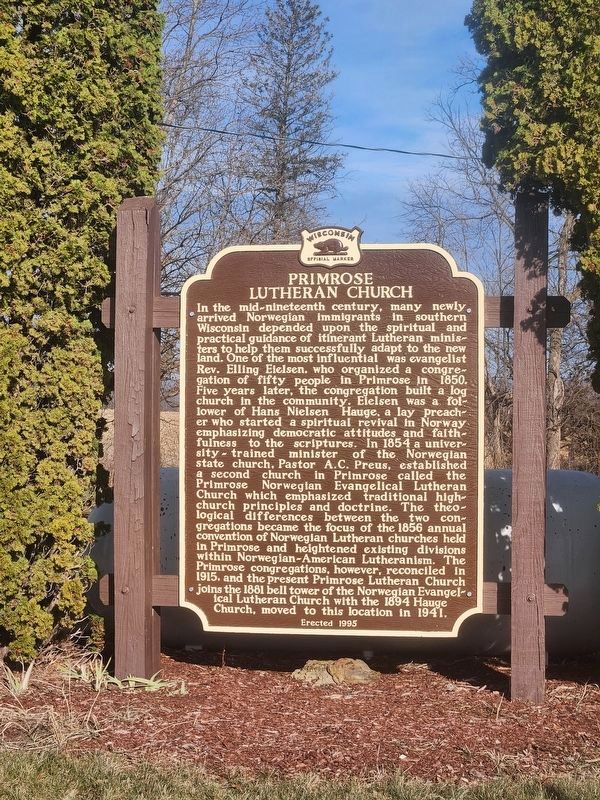
On Ridge Drive at Primrose Center Road, on the right when traveling west on Ridge Drive.
In the mid-nineteenth century, many newly arrived Norwegian immigrants in southern Wisconsin depended upon the spiritual and practical guidance of itinerant Lutheran ministers to help successfully adapt to the new land. One of the most influential . . . — — Map (db m55047) HM
On East Church Road 0.4 miles west of Hillside Road, on the right when traveling west.
Koshkonong Prairie with its twin churches at both East and West Koshkonong is one of the focal points from which Norwegian Lutheranism spread to many parts of the American continent.
In 1844 at the request of pioneer Norwegian immigrants . . . — — Map (db m36145) HM
On County Route Z 0.5 miles west of Wisconsin Highway 78, on the left when traveling north.
Early Norse pioneers who realized a need for a house of worship built the first Norwegian Lutheran Church in western Dane County from logs in the winter of 1851-52. First services held May 27, 1852 by the Rev. A.C. Preus. Previous itinerant pastors . . . — — Map (db m36718) HM
On South Main Street (County Highway CV) near Holum Street, on the right when traveling south.
Andreas Dahl came to DeForest from Valdres, Norway in 1869. For more than a decade as an itinerant photographer in southern Wisconsin, he took pictures that captured the essence of life at that time. His studio stood to the north of this site and . . . — — Map (db m37005) HM
On East Main Street at South Pinckney Street, on the left when traveling east on East Main Street.
Colonel 15th Wis. Vols. Born in Norway Dec. 21, 1829 Fell at Chickamauga Sept. 19, 1863 Norwegian Americans gave this memorial to the State of Wisconsin — — Map (db m33780) HM
On Hudson Avenue at Center Avenue, on the left when traveling north on Hudson Avenue.
Herman Loftsgordon and his family lived in this house from 1918 until 1946. Loftsgordon was one of five brothers who came to Madison from Mt. Horeb in the early 1900's and settled within blocks of each other in the Elmside plat. The family was . . . — — Map (db m41523) HM
Near Observatory Drive, on the right when traveling west.
Born of Norwegian parents in town of Albion, January 12, 1846 Member of the University faculty 1869-1883 United States Minister to Denmark 1885-1889 Died in Madison, Wisconsin, March 2, 1936 First Wisconsin-born professor on the University faculty . . . — — Map (db m32739) HM
Near Thorstrand Road 0.2 miles north of University Avenue, on the right when traveling north.
These two Mediterranean Revival mansions were designed for Magnus and Annie Swenson and their daughter Mary North by Madison architects Law and Law. Swenson was a Norwegian immigrant who became an internationally famous inventor and humanitarian. . . . — — Map (db m46031) HM
On Dickinson Street at Wilson Street, on the left when traveling south on Dickinson Street.
John A. Johnson made a bold move when he co-founded an agricultural implement company in Madison in 1880. Many civic leaders opposed manufacturing, fearing the workers would lower the city's moral and intellectual tone.
But Johnson proved his . . . — — Map (db m32919) HM
On South Franklin Street at East Main Street, on the right when traveling north on South Franklin Street.
Emily Torstensenseim immigrated to the United States from Norway with her parents at the age of four. When she grew up she married a fellow Norwegian immigrant, Ole Thompson, who became a successful hotelier and grocer. Shortly after his death, his . . . — — Map (db m73067) HM
On Main Street (County Road MN) at Bashford Street, on the left when traveling south on Main Street.
Prehistoric woodland Indians built effigy mounds on the many glacial drumlins in this area, including those in Indian Mound Park. Later Winnebagoes lived along the shores of Lake Waubesa and the Yahara River. They ceded the land to the government in . . . — — Map (db m33761) HM
On State Highway 78 0.1 miles north of County Road ID, on the right when traveling north.
Pioneer Mt. Horeb, complete with houses, churches, stores, harness shop, undertaker, hotel, and tavern stood on this spot. Known as “The Corners” by early settlers, it was the intersection of the Old Military Road with a major wagon . . . — — Map (db m33881) HM
On Town Hall Road at U.S. 18-151, on the right when traveling north on Town Hall Road.
Norwegians came to this peaceful area of rolling hills and valleys in 1846 and organized a Lutheran congregation in 1852, holding services outdoors and in homes. These God-fearing people purchased 2 acres of land for a church and cemetery in . . . — — Map (db m272537) HM
On County Highway B at Spring Road, on the right when traveling east on County Highway B.
"Now may the Lord bless this step which we have taken not out of a desire for discord and dissuasion but compelled by the voice of our conscience." With this prayer on their lips, six families met at Lars Bovre's farm on June 22, 1860 to organize . . . — — Map (db m37293) HM
On South Page Street at West Jefferson Street, on the right when traveling south on South Page Street.
Stoughton was founded by Luke Stoughton in 1847. The first settlers were Yankees from New England.
Waves of Norwegians immigrated to the community during the late 19th century to make Stoughton America's Norwegian capital, home of lutefisk and . . . — — Map (db m36256) HM
On Koshkonong Road at Church Street, on the left when traveling east on Koshkonong Road.
Founded on October 19, 1844 A part of the second oldest Norwegian Lutheran Parish in America Present structure built in 1892 Additions 1960 and 1967 — — Map (db m41586) HM
Near County Route NP 4.2 miles east of Wisconsin Route 42.
"There is a certain irony to the fact that Wisconsin's only formally designated Wilderness Park was once a bustling village."
—Robert J.W Erwin
Wisconsin Natural Resources Magazine
On State Highway 42 0.1 miles south of Humbug Road.
Scandinavian immigrants often told their children stories of giant, mischievous beings connected to nature - mountains, forests and caves.
Do not climb on them because they sometimes ate naughty children in tales from Norway, Sweden and . . . — — Map (db m254227) HM
Near State Highway 42 at Anderson Lane, on the right when traveling south.
Aslag Anderson, Norwegian born mill-wright, built this store and dock in 1858.
The dock served as the transportation center for this area from the sailing days through the steamship era in the 1920's.
On Anderson's death in 1892, two of . . . — — Map (db m57690) HM
On Shore Road 4.5 miles north of Main Street (Wisconsin Highway 42), on the left when traveling north.
Northern white cedar trees cling to the rocky rim of 38-acre Horseshoe Island. A tangle of birch and balsam fir, with pale blossoms of climbing fumitory, grow on the island, too. Long ago, people lived on Horseshoe Island.
Indian people, . . . — — Map (db m74416) HM
Howard loved the water, sailing and knew all about ships. He was a sailor, shipbuilder, boat launcher, and a long-time DCMM docent. He couldn't wait to sail each spring.
Lou was a great supporter of Howard. She cared for their home, children, . . . — — Map (db m89897) HM
On Lobdell Point Road 0.1 miles north of Green Boulevard, on the right when traveling south.
The Coffee Pot is a symbol of Washington Island hospitality and ingenuity.
The concept was developed by Martha Stelter and Mary Richter for the
Washington Island Girl Scout Troop. The Scouts used the Coffee Pot
to raise money to pay for the . . . — — Map (db m232541) HM
On Main Road 0.5 miles north of Michigan Road, on the right when traveling north.
Little Norwegian Village
Brought over from Telemark, Norway in 1989, these log buildings were built and assembled like lincoln logs in one month with the help of three Norwegians, establishing a building complex that represented the heritage of . . . — — Map (db m232609) HM
Near First Avenue at Hudson Street, on the left when traveling south.
"Immigrants are pouring in...land I would never have thought of choosing is being taken up." Writing from Chippewa County's Clear Water post office in 1855, Thomas Barland could scarcely have imagined the tide of immigrants yet to land in Eau . . . — — Map (db m43563) HM
Near Whipple Street north of Fulton Street, on the left when traveling north.
Its doors are open to every sufferer, with no shadow of restriction as to the color of their skin or of their money, or the shade of their religious belief."
Dr. Hans Christian Midelfart
. . . — — Map (db m75336) HM
On State Highway 85 0.5 miles west of State Highway 37, on the right when traveling west.
Dominating the vicinity, the Silver Mine Ski Jump is 351 feet above the Chippewa River and is considered one of the largest ski jumps in the country. Built by the Eau Claire Ski Club in 1969, this jump replaces another built in 1887, at the nearby . . . — — Map (db m21231) HM
On 15th Street South at Winnebago Street, on the right when traveling north on 15th Street South.
The Colton Mission Chapel at 1502 Winnebago Street, built by the First Baptist Church in 1893, was used by the Norwegian Evangelical Free Church from 1918 until the 1940's. The Norwegian Methodist Evangelical Church, built at 1503 Winnebago Street . . . — — Map (db m185929) HM
Near State Highway 78 1 mile south of County Route N.
Norwegian immigrants formed this congregation in 1844 and began constructing their church in 1847. This is the oldest Norwegian Lutheran church still in use in America. — — Map (db m55050) HM
On North Liberty Street near North Calumet Road (U.S. 151), on the left when traveling north.
Thorstein Bunde Veblen, an internationally recognized economist, was born one mile north of Valders on July 30, 1857. The sixth of twelve children of Norwegian immigrants Thomas Anderson Veblen and Kari Bunde Veblen, Veblen spent his first . . . — — Map (db m257907) HM
On County Road T south of Trout Creek Road, on the left when traveling north.
Early Norwegian immigrants settled Central Wisconsin in the mid-1800s and brought with them the traditional church architecture still found in the hills and fjords of their native land. South New Hope Church was chartered in 1888 when synod debates . . . — — Map (db m156507) HM
On Washington Avenue (State Highway 32) at 6th Street, on the right when traveling west on Washington Avenue.
The Building
In 1929, the Racine Common Council began the process of creating a new City Hall. The council received two design proposals: one from local architect J. Mandor Matson and another from a Chicago firm. The mayor and aldermen . . . — — Map (db m69164) HM
On Heg Park Road at Norway Hill Road, on the right when traveling north on Heg Park Road.
Under the leadership of John Luraas, forty pioneers came to Muskego Lake from Norway in 1839, to found one of the most important settlements in Norwegian-American history. After temporary set-backs, the settlement flourished here through the . . . — — Map (db m34221) HM
Near South Bergen Road north of East State Line Road.
On this spot and in a small frame church known as the Norwegian Lutheran Church of Clinton, Rock County, Wisconsin, gathered on the Fifth Day of June, 1860, the following named ministers of the gospel:
L. P. Esbuörn · T. N. Hasselquist
P. . . . — — Map (db m26317) HM
On State Highway 140 at East State Line Road, on the right when traveling south on State Highway 140.
Ole Knutson Nattestad, first Norwegian settler in Wisconsin, came to Clinton Township, July 1, 1838. In his native Numedal, Nattestad had been a farmer, peddler, and blacksmith. In 1836 he and his brother Ansten visited Stavanger and . . . — — Map (db m22794) HM
On West Grand Avenue (County Highway Q) 0.1 miles west of South Webb Street, on the right when traveling west. Reported missing.
The Norwegian Lutheran Synod dedicated an Indian mission and boarding school on this site in 1887, the same year Congress passed the Dawes Severaty and General Allotment Act. The school boarded as many as 159 children at a time from the Indian . . . — — Map (db m29131) HM
Indian trails crossed heavily forested land when the first speculator, John Rockwell, came to what is now called Stone Bank in 1839. He purchased land from the government for $1.25 per acre. John Johnson arrived in 1840. John Weigand, J. Weichert, . . . — — Map (db m44345) HM
On East State Street (State Highway 49) at South Washington Street, on the right when traveling west on East State Street.
Iola is located in the area previously known as the “Indian Land” – the land west of the Wolf River and north of the Waupaca (Tomorrow) River. It was opened for settlement after an 1848 treaty, initially disputed by members of the Menomonee tribe . . . — — Map (db m67232) HM
On County Highway G 0.8 miles north of County Highway B, on the left when traveling north.
Norwegian Evangelical Lutheran
Church of Our Redeemer,
first Lutheran church in Waupaca
county, was built in 1856
directly across the road. It was
enlarged in the form of a Cross
in 1867, and demolished in 1928.
Pastor Nils Brandt . . . — — Map (db m21919) HM
On Day Road at Mill Creek Drive, on the left when traveling south on Day Road.
On January 13, 1906, forefathers from Norway established the church. The first pastor to serve was Reverend J.C. Hougum.
The church building was constructed in 1907 by Jorger Erickson, Knute Evenson, Ole Gunderson, Knute Jonsrud, Ole Jorstad, . . . — — Map (db m5045) HM
On Kongens gate at Rådhusgata, on the left when traveling south on Kongens gate.
24. juni 1944 ble
konsul Sigurd Emil Roll
bortført av Gestapo fra sitt
kontor i Sjøfartsbygningen. Han
ble henrettet samme dag ved
Holmenkollen kapell, som en del
av «Operasjon Blumenplücken».
Gestapo anså han som en . . . — — Map (db m276497) HM
240 entries matched your criteria. Entries 201 through 240 are listed above. ⊲ Previous 100