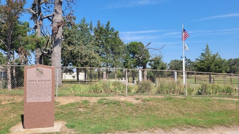
The Osage Chief. Grave here, 1908. When the Osages came to live in Indian Ter. after the Civil War, Bigheart became chief and led in organizing the Osage Nation under a written constitution. He had a trading post at Bigheart, now Barnsdall, and led . . . — — Map (db m284488) HM
The manufacture of chemicals from petroleum had its beginning in the southwest at the Tallant Gas Processing Plant located 3 miles north of here at the bend of State Highway 11 and Bird Creek.
Built in 1926 by a Cities Service Company . . . — — Map (db m284496) HM
This bell hung in the First Methodist Church in Conway, Iowa.
This was the church that Frank Phillips and his family attended in the late 1800's.
The old church burned in 1919 and the bell moved to the L.E. Phillips Ranch (Philson Farms) in . . . — — Map (db m284523) HM
In memory of and tribute to all veterans.
Dedicated to those who have served
George Dillon • Peter C Bigheart • L B Calvin • Strother N Shaw • James W Sapp • William Todd • Chester W Owen • James P Middlebrook • Ed Batschelett • Orville V . . . — — Map (db m206317) WM
"New Territory" is local artist, Cha' Tullis' depiction of years past as a party of Indians top a hill to find a valley with fresh running water; a perfect place to camp and rest. Made of 1/4" sheet steel, pipe and sucker rods, the sculptured . . . — — Map (db m81147) HM
Donated by William and Joffa Kerr
November 2009
Upon the 20th Anniversary of the
Tallgrass Prairie Preserve
In honor of the
Founding Board of Directors
Oklahoma Chapter of
The Nature Conservancy
For their visionary conservation . . . — — Map (db m81265) HM
The Osage Tribe of Indians held the first public auction sale for oil leases on Osage Reservation tracts November 11, 1912. Early sales were held under this elm tree. Bidders sat on bleachers around the tree and the auctioneer, Colonel E. Walters, . . . — — Map (db m81172) HM
Stephen Easley, a native of Pawhuska, and his wife Debra noticed the unique architectural design of the Whiting apartment buildings and said a simple prayer. The Whiting Apartments had much character and lots of potential, but were in a . . . — — Map (db m81161) HM
Built in 1871, this 5-room house with native timbers and 18" thick sandstone walls was the first to be built in Pawhuska. When the Osages were moved from Kansas, Sid Delarue, a Swiss blacksmith, was promised the house if he would come to care for . . . — — Map (db m55655) HM
By 1760 the Osage of Missouri had increased their range to include present day Osage County. In 1835 the area was included in the "perpetual outlet west" guaranteed to the Cherokee Nation under the Treaty of New Echota. In 1870, under the Cherokee . . . — — Map (db m284711) HM
Organized by Rev. John Mitchell May 1909
Rev. Mitchell • W. B. Johnson • J. L. Johnson • J. C. Ferguson • J. Hutchings • D. F. Millard • L. Copeland • R. A. McGuire • J. S. McGuire • R. E. McGuire • R. D. Foote • R. W. Blanc • N. A. Tinker • J. . . . — — Map (db m81173) HM
This is a transitional boundary between the Plains Indians and the eastern tribes; these lands are called the Cross Timbers. Hailed a "Forest of Irons" by its first explorers, it is one of the oldest and least disturbed forest ecosystems.
The . . . — — Map (db m284738) HM
In November 1829, three Osages arrived in Montauban, the Occitan Region of France. Little Chief, Big Soldier and Hawk Woman crossed the Old Bridge, received help from Bishop Dubourg, and with the generosity of the people of Montauban they were . . . — — Map (db m83108) HM
Symbolic of the impact oil had on the people of the Osage Indian Nation is the so-called "Million Dollar Elm." It was given this name because in its shade millions of dollars worth of Osage oil leases were auctioned. It was planted at this site . . . — — Map (db m83107) HM
The buffalo supplied essential food for the Osage, and buffalo tongues and robes were valuable trade items. The buffalo country between the upper Red River and the Arkansas along the Washita, Canadian, and Cimarron Rivers was extremely important to . . . — — Map (db m284712) HM
Osage County was once a part of the vast homelands of the roaming Osage tribe, but in the early 1800's the land was given to the Cherokee tribe by the American government. In the late 1800's when the Osage tribe relocated from Kansas to Oklahoma, . . . — — Map (db m284734) HM
Because of its wealth and location, the Osage Hills became an unwilling host to many outlaw gangs in the 1800's.
This land was an easy refuge for villains and outlaws because of its isolation and rugged terrain. It was far from Fort Smith, . . . — — Map (db m284736) HM
Pawhuska, Oklahoma county seat of Osage County
was named for well known Osage Chief
Pa-Hus-Ka whose name means White Hair
The Post Office was established May 4, 1876
A community who embraces with pride the
reflections of our past and . . . — — Map (db m55651) HM
The legacy of oil and the Osages is one of the most intriguing facts of the oil industry in America.
On March 16, 1896, the first oil and gas lease was obtained covering all the Osage Reservation, and on October 28, 1897 the first producing . . . — — Map (db m55652) HM
In memory and dedication to those whose foresight, frustrations and sacrifices have helped the Osage Tribe to preserve its identity [sp], development and culture.
1865 - The Osages agreed to the sale of their Kansas lands.
1871 — . . . — — Map (db m55653) HM
The Easleys have taken much pleasure in restoring the Whiting Apartments. Most all of the restoration has been done by the Easleys themselves, although they do not wish to ignore the many handy men who have helped. Stephen and his wife Debra, who . . . — — Map (db m81171) HM
One-half mi SW. Est. 1887 by St. Katharine Drexel and Bureau of Catholic Indian Missions, Washington, D.C. Original frame structure located near Main and Palmer burned in 1889, replaced here 1890 by a four-story stone building. Operated by . . . — — Map (db m55657) HM
Near this site on August 8, 1903, U.S. Deputy Marshal Wiley G. Haines, Chief of Osage Indian Police Warren Bennett, and Constable Henry Majors ended the career of the notorious outlaw gang known as the Martin brothers. The outlaws were wanted for . . . — — Map (db m52632) HM
Pawhuska's venerable landmark that's thrilled and terrified every creek crosser since the early days of Pawhuska. In its original use, the swinging bridge was the only way people could get across the creek into Pawhuska.
Kids love it! Those . . . — — Map (db m284505) HM
You are standing on the south edge of the largest unplowed, protected tract that remains of the 142 million acres of tallgrass prairie grassland that stretched from Canada to the Gulf of Mexico. Today, less than ten percent still exists, found . . . — — Map (db m76602) HM
Vernon Whiting, builder of the "Historical Whiting Apartments" in the 1920's, was born in 1870 in Ogdensburg, New York. His family later moved to Seward, Nebraska. Vernon graduated high school there in Seward, then took a business course at . . . — — Map (db m81152) HM
This site, 3.5 miles N.W. is where Col. Jas. McIntosh, 2nd Ark. Mtd. Rifles, routed Loyal Union Indian forces, Dec. 26, 1861. The battle started with fire from the Indian line on Patriot's Hill, 2 Mi. S.W. The Loyal Indians finally fled into Kansas. — — Map (db m216344) HM
Established by Rev. John Murdock, under auspices of Friends Society, 1882. This noted school was attended by both Indian and white children. In this vicinity, was home of Wm. C. Rogers, last elected principle chief of Cherokee Nation, 1903 to 1917. . . . — — Map (db m7356) HM