On Adelaide Street East just east of George Street, on the left when traveling east.
[English] Chartered in 1821, the Bank of Upper Canada, was until its demise in 1866, one of British North America's leading banks. It played a significant role in the development of Upper Canada — supplying currency, protecting . . . — — Map (db m199444) HM
On Church Street just north of King Street East, on the right when traveling north.
In 1796 the first Anglican priest arrived from England to minister to the citizens of York. The following year the province set aside this piece of land for the building of a church. The present cathedral, the fourth church erected on this site, . . . — — Map (db m217444) HM
On Jarvis Street just north of King Street East, on the right when traveling north.
This building was first constructed in 1833 for owner Daniel Brooke, a prominent merchant in the Town of York. It was substantially rebuilt between 1848-1849 prior to the Great Fire of April 1849 which started in a nearby stable. While much of the . . . — — Map (db m217196) HM
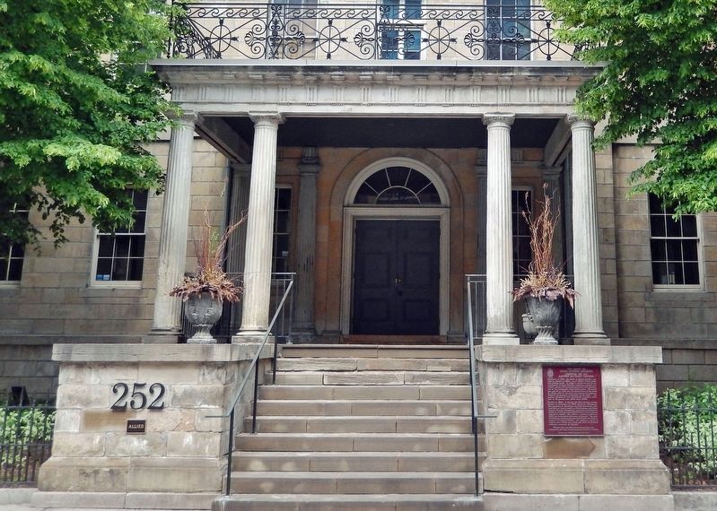
On King Street East just west of Jarvis Street, on the right when traveling west.
The township of York held council meetings above this branch of the Canadian Imperial Bank of Commerce from 1907 to 1950. This plaque commemorates the 180th anniversary of the founding of the township. This plaque was installed December . . . — — Map (db m217195) HM
On Church Street at Adelaide Street East, on the right when traveling north on Church Street.
[English] The Mechanics' Institute movement began in Britain and soon spread to North America. Its aim was to teach workers the applied technology behind new methods of manufacture and craftsmanship introduced during the Industrial . . . — — Map (db m199995) HM
On Adelaide Street East just east of George Street, on the left when traveling east.
[English] Originally all post offices in Upper Canada were owned by the postmasters in charge, who were imperial appointments. This building was constructed for postmaster James Scott Howard during 1833-1835 and functioned as the . . . — — Map (db m208172) HM
"Sunlight Park" was constructed in 1886 as the Toronto Baseball Grounds. The smell of baked potatoes and cigars greeted fans filing in to the park through an avenue of workers' cottages called "Baseball Place". The stands, four storeys high and . . . — — Map (db m64502) HM
On King Street East just east of Church Street, on the right when traveling east.
Mary Ann Shadd Cary was an anti-slavery activist, an advocate for the rights of women, and a pioneering woman newspaper editor and publisher. The daughter of a free African American shoemaker and abolitionist, Shadd began a life of teaching at age . . . — — Map (db m57756) HM
On Queens Park close to Bloor Street West, on the right when traveling south.
Born in Exeter, Huron County, this renowned archaeologist, teacher and administrator was educated locally and in Toronto. Completing his studies at Victoria College, he received his B.A. from the University of Toronto in 1898 and his M.A. in 1901. . . . — — Map (db m83666) HM
{in English:}
A scholar of diverse interests and talents, Daniel Wilson was noted in Britain as the author and illustrator of studies of old Edinburgh and of Scottish prehistory. In 1853 he was appointed to the chair of history and . . . — — Map (db m37010) HM
On Saint George Street just south of Wilcocks Street.
Sir John A. Macdonald, Canada's first prime minister, purchased this house in 1876 and lived here 1876-78. It was built in 1872 in the French Second Empire style by Nathaniel Dickey, a Toronto iron founder. Macdonald owned the property until 1886 . . . — — Map (db m36978) HM
On Queens Park close to Bloor Street West, on the right when traveling south.
The first Director of the Royal Ontario Museum of Palaeontology, Parks was born in Hamilton and educated at the University of Toronto, from which he received a Doctorate in 1900. Initially known as an expert on "stromatoporoids", a unique group of . . . — — Map (db m83663) HM
The province's first sailing association, the Toronto Boat Club, was formed in 1852 and two years later became the Royal Canadian Yacht Club. Dedicated to the promotion of yachting and naval interests, it initiated competitions which stimulated . . . — — Map (db m37067) HM
On Simcoe Street at King Street West, on the right when traveling south on Simcoe Street.
From 1829 to 1891 the block bounded by King, Simcoe, Adelaide and John Streets, then known as Russell Square, was occupied by the buildings and grounds of Upper Canada College. This tablet was placed here on September 13th, 1929, at the time of . . . — — Map (db m217334) HM
Near University Avenue, 0.2 kilometers north of Queen Street West, on the right when traveling north.
[English] The fountains at 361 University Avenue were originally designed in 1964 by Landscape Architect Michael Hough to anchor the west end of the pedestrian mall that links University Avenue to Nathan Phillips Square. Symbolic of . . . — — Map (db m243783) HM
Near Queen Street West just east of University Avenue, on the left when traveling east.
In 1829-32 the Law Society of Upper Canada erected the east wing of this imposing building. Named after William Osgoode, the province's first chief justice, the Regency structure housed law courts and judicial offices, and provided accommodation for . . . — — Map (db m196169) HM
Near University Avenue, 0.2 kilometers north of Queen Street West, on the right when traveling north.
[English]The McMurtry Gardens of JusticeThe McMurtry Gardens of Justice encourage visitors to reflect upon the proud history of our legal process, the challenges yet to be addressed, the rights that Canadians too often take for . . . — — Map (db m243790) HM
On University Avenue, 0.2 kilometers north of Queen Street West, on the right when traveling north.
ON THIS SITE STOOD the UNIVERSITY AVENUE ARMOURIES, the home of famous Toronto Regiments of the Canadian Army and the centre of Militia activities in Toronto from 1891 until it was demolished in 1963. A spacious riding school and gun park, erected . . . — — Map (db m217194) HM
On University Avenue just north of Queen Street West, on the left when traveling north.
A renowned Canadian sculptor, Allward was born in Toronto and attended Central Technical School. He studied under William Cruikshank and Emmanuel Hahn, prominent Canadian sculptors, and later in London and Paris. His first important commission, the . . . — — Map (db m208089) HM
Near Queen Street West just west of York Street, on the right when traveling west.
[English] Founded in 1919, the Women’s Law Association of Ontario (WLAO) was the first organization to work actively to create a place for women at Osgoode Hall. With membership open to law students, lawyers and judges, the . . . — — Map (db m199999) HM
120 entries matched your criteria. Entries 101 through 120 are listed above. ⊲ Previous 100